
California and National Drought Summary for December 22, 2015
Summary
Strong troughs moving in a fast westerly flow dominated the weather across the CONUS this U.S. Drought Monitor (USDM) week. The troughs brought Pacific cold fronts and low pressure systems which pounded the Pacific Northwest coast. Some of the troughs formed closed lows over the West which blanketed the coastal ranges to Rocky Mountains with welcomed snow. As they moved east, the low pressure systems drew in Gulf of Mexico moisture to dump heavy rain and snow over parts of the Great Plains to East Coast. The precipitation largely missed Arizona and New Mexico in the Southwest, much of the Southern Plains to Kansas, and parts of the Northern Plains in western North Dakota, eastern Montana, and north central Wyoming. At least 2 inches of precipitation fell in parts of the West and Southeast – from San Francisco Bay to the Canadian border and from the Cascade Mountains to the west coast; and from southern Mississippi and Alabama to central North Carolina. Heavier amounts fell in favored upslope areas – more than ten inches fell along the Oregon and northern California coast, with 13.27 inches of precipitation reported for the last 7 days at the CoCoRaHS station at Brookings, Oregon and 10.10 inches at Crescent City, California; five inches or more of precipitation was widespread across California’s Sierra Nevada range. Half an inch to two inches fell across parts of the Great Basin to much of the interior Pacific Northwest and Northern Rockies; across parts of the Northern Plains; and across much of the country east of the Mississippi River. A thick blanket of new snow was laid down from Nebraska to Minnesota, with up to 13 inches of snow measured in parts of North Dakota. The precipitation was enough to contract drought and abnormal dryness in the Pacific Northwest and western Montana, Northern Plains, and Southeast. But drought or abnormal dryness was added in areas where precipitation has been deficient over the last 30 to 90 days, including the Big Horns in Wyoming, northeast Ohio, western New York, and coastal Texas.Alaska, Hawaii, and Puerto Rico
High pressure kept most stations in Hawaii drier than normal this USDM week, and it was a dry week across Alaska and Puerto Rico. D1 was expanded westward across the southern coast of Puerto Rico to reflect dry soils. Otherwise, no change was made to the depiction in Alaska, Hawaii, or Puerto Rico.Great Plains to Mississippi Valley
The fronts that moved across the central part of the country dropped locally heavy precipitation across parts of Nebraska and the Dakotas, but were mostly dry from southeastern Nebraska to most of Texas. Parts of the Mississippi Valley received half an inch to an inch of precipitation, with the Lower Mississippi, from eastern Texas to Louisiana, getting locally 2 to 3 inches. D0 was pulled back in northwest Nebraska, the Dakotas, and western Minnesota, and D1 trimmed in North Dakota. The precipitation in northern Minnesota helped recharge the topsoil moisture, but subsoil moisture was still short, so the D0 was contracted but not eliminated there. D0 was added to coastal Texas to reflect dry conditions for the last 30 days to 6 months.Southeast
Much of the Southeast received 0.5 to 2.0 inches of rain, with up to 6 inches in parts of southern Alabama and central Georgia. The CoCoRaHS station Ramer in Montgomery County, Alabama, reported a 7-day total of 6.03 inches. But amounts were less than half an inch in the southern half of Florida and much of coastal Georgia and the coastal Carolinas. With soils saturated and streamflow normal, the D0 in southeast Alabama was eliminated. The western edge of the D0 in southeast Georgia was trimmed, but it expanded up the coast.Southwest
Half an inch to 2 inches of precipitation fell across the mountains of Utah and Colorado, but Arizona and New Mexico were mostly dry this week. Local authorities received reports of poor range conditions in the D-Nothing area of La Paz County in southwest Arizona, and precipitation deficits were evident in AHPS and SPI indicators, so this area was filled in with D0. In New Mexico, many of the indicators show normal to wet conditions, except the reservoirs which continue to be below normal. D0 was kept in place in western New Mexico to reflect the poor reservoir conditions.The Ohio Valley, Great Lakes, and Northeast
A frontal system moved across the Ohio Valley to Northeast at the beginning of the week, with another near the end of the week. These systems dropped a weekly total of half an inch to an inch of precipitation across much of the area, with locally up to 1.5-2.0 inches. But some areas had considerably less, and three of these areas have had deficient precipitation for much of the last 90-120 days. The dryness was also reflected in dry modeled soil moisture and low streamflow. D0 was expanded to fill in a D-Nothing area from Allen County, Ohio to Huntington County, Indiana; D1 was added to northeast Ohio; and, in western New York, D0 expanded along the shore of Lake Ontario and D1 was added in and around Niagara County. Even though half an inch to an inch of precipitation fell over eastern Massachusetts, this was still below normal for the week. D1 was expanded into the Attleboro area to reflect low streamflows, below-normal precipitation for the last 6 months, and local water use restrictions which were recently put into effect.The Pacific Northwest, California, Great Basin, and Northern Rockies
A series of Pacific weather systems slammed into the Pacific Northwest this USDM week, bringing heavy rain along the coast and windward side of the coastal mountain ranges, with beneficial snow to the higher elevations. SNOTEL station reports of precipitation for the month to date totaled more than 200% of the monthly normal across much of Washington, Oregon, and Idaho, and were above normal for most stations for the water year to date (October 1-December 22, 2015) (WYTD). Some stations in the Washington Cascades had 150-200% of normal precipitation for the WYTD and were among the wettest 5% in the historical record. But this is still early in the wet season, with the precipitation totals so far at most stations not even halfway to the normal total for the entire seasonal. Most Pacific Northwest SNOTEL stations gained several inches of snow this week, with some Washington and northern Idaho stations gaining 2 to 3 feet of new snow. The snow water content of many Pacific Northwest stations was above normal, with some in the wettest 5% of the historical record. But, it should be pointed out again that this is early in the snow season and virtually all of the stations are below the seasonal peak value, with most not even halfway there.Reservoirs responded slowly, but did see some improvement. In the Yakima River Basin in Washington, reservoir levels improved a few percentage points, with December 21 Bureau of Reclamation reports indicating Cle Elum was 48% full, Kachess 45% full, Keechelus 60%, and Rimrock 56%. These are near to above average for the date. Reservoir levels improved slightly but were still well below average in Oregon – only 10-20% full in the Umatilla River Basin and 5-35% full in the eastern Oregon basins. In Oregon’s Crooked and Deschutes River Basins, Prineville Reservoir was 31% full and Wickiup 48%. In southwest Oregon, the Emigrant reservoir was 16% full, Hyatt 11%, Howard Prairie 16%, and Fourmile Lake 14%. Reservoirs in western Idaho continued below average.
With improved mountain snowpack, improving reservoirs, and precipitation deficits erased out to the last 9 months, D0-D2 were pulled back along the Washington Cascades and into the Yakima River Valley. The D2 was kept in place across southeast Washington where precipitation deficits are notable at the 6 to 24 month time scales. In Oregon, D0-D1 were pulled back along the coast and some areas of the windward side of the Cascades, and D2 was trimmed in Josephine County, but no change was made elsewhere.
Well-above-normal precipitation prompted the pullback of D0-D2 in western Montana and in Judith Basin and Fergus counties east of the divide. But the Big Horn area of northern Wyoming has missed the beneficial precipitation of recent storm systems. Low streamflows, below-normal precipitation and Standardized Precipitation Evapotranspiration Index (SPEI) values for the last week to 6 months, dry soils, and SNOTEL snow water equivalent values in the lowest 5% of the historical record prompted the addition of D1 over this part of north central Wyoming.
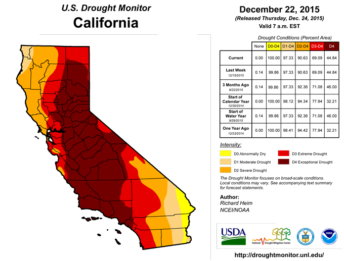
In California, 4 inches or more of precipitation fell along the northern coast and along the Sierra Nevada, with precipitation amounts dropping off rapidly further south. Some Sierra Nevada SNOTEL stations gained 1 to 2 feet, or more, of new snow, with many above normal for this time of year. But it must be stressed that this is still early in the snow season and we have many months to go before a sufficient snowpack is built up to meet spring and summer meltwater needs. The California Department of Water Resources (DWR) noted that, on a statewide average basis, the average snow water equivalent of mountain snowpack increased to 9 inches by December 22, an increase of 3 inches compared to a week ago, but it was still only 32% of the April 1 peak value. DWR reservoir levels barely changed in the last week, but the precipitation has increased the level of Lake Tahoe along the California-Nevada border, with about 13,300 acre-feet or 4.3 billion gallons of new water added. However, the lake is still 1.4 feet below reservoir gate level and another 6 feet below the fill level. With this week’s precipitation having minimal impact on the water resources of California and Nevada, no change was made to the USDM depiction in California and most of Nevada, except to change the impacts label to L in northern California and southern Oregon to reflect short-term wetness.
D0-D1 were pulled back in Elko County in northeast Nevada, and in adjacent southern Idaho, where streamflow was near normal and snowpack above normal. Precipitation was above normal for the week, month, and WYTD, and the moisture deficits for much of the last 6 years have been eliminated in this area according to the SPEI. Improving conditions along the northeast Nevada-Utah state line prompted pullback of D2.
Looking Ahead
During the next 5 days (December 24-29), an upper-level trough will set up over the West with a ridge over the eastern CONUS. Along the trough/ridge boundary, a strong low pressure and frontal system will generate widespread precipitation which will spread across the eastern half of the CONUS. Half an inch of precipitation, or more, is forecast from the Plains to the East Coast, with 3+ inches from eastern Oklahoma to the Ohio Valley. A tenth to half an inch are forecast across much of the West, with 1 to 3 inches expected along the coast from northern California to Washington. Exceptions include the interior Pacific Northwest, much of the northern Plains, southern California to southwest Arizona, and Florida, where little if any precipitation is predicted. Below-normal temperatures are expected over the West with above-normal temperatures from the Plains eastward.For the ensuing 7 days (December 30-January 5), temperatures will remain cooler than normal beneath the trough in the West and above normal beneath the eastern ridge. The odds favor below median precipitation across the West, the northern and central Plains, and Ohio Valley to Great Lakes. Above-median precipitation is expected from the southern Plains to the Southeast and up along the Eastern Seaboard. The outlook is for wetter- and warmer-than-normal weather for much of Alaska.
Author(s):
Richard Heim, NOAA/NCEI
Dryness Categories
D0 ... Abnormally Dry ... used for areas showing dryness but not yet in drought, or for areas recovering from drought.Drought Intensity Categories
D1 ... Moderate DroughtD2 ... Severe Drought
D3 ... Extreme Drought
D4 ... Exceptional Drought
Drought or Dryness Types
S ... Short-Term, typically <6 months (e.g. agricultural, grasslands)L ... Long-Term, typically >6 months (e.g. hydrology, ecology)
Source: National Drought Mitigation Center