
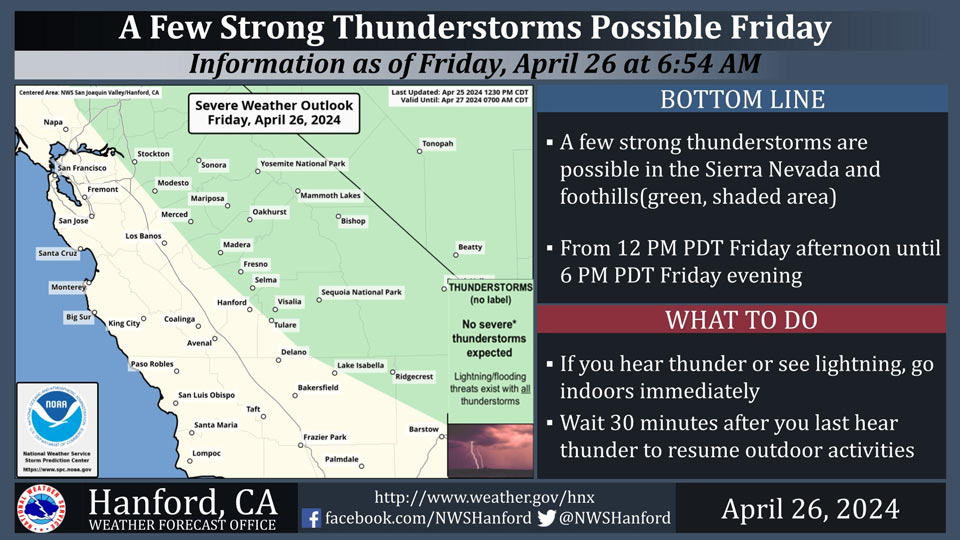
Possible Thunderstorms in portions of Mariposa, Madera, Fresno and Tuolumne Counties and Yosemite National Park
April 26, 2024 - National Weather Service Hanford Office officials report the Storm Prediction Center has put the Sierra Nevada and adjacent foothills under a risk for general thunderstorm today (green, shaded area).
These storms will most likely develop between 12 PM and 6 PM this afternoon.
Area Forecast Discussion
National Weather Service Hanford CA
437 AM PDT Fri Apr 26 2024
&&
.KEY MESSAGES...
1. A High Wind Warning has been issued for the Kern County
Mountains and Mojave Desert Slopes through 11 PM PDT this
evening.
2. A storm system will impact Central California today with
mountain snow and thunderstorms which have the potential to
extend into the foothills and eastern San Joaquin Valley.
3. Maximum temperatures today are expected six to ten degrees
below seasonal averages.
4. A warming trend begins on Sunday and will last through the
week ahead with dry conditions.
&&
.DISCUSSION...
A deepening upper level trough will pass through central
California today and push into the southwestern US later this
evening. Northwesterly flow aloft in the upstream portion of the
trough will result in cooler temperatures across the region.
Afternoon maximums in the San Joaquin Valley and Kern County
Desert are expected in the upper 60s to low 70s, around eight to
ten degrees below normal for this time of year. High
temperatures in the Sierra Nevada and surrounding foothills have
the potential to be up to fifteen degrees below seasonal
averages.
In addition to cooler temperatures, the aforementioned flow
aloft will result in stronger winds across the region this
afternoon and evening. Probabilistic guidance from the HREF
expresses a moderate chance (50-70%) for wind gusts to exceed 25
miles per hour in the San Joaquin Valley today. Meanwhile, a
Wind Advisory has been issued which includes Indian Wells
Valley, Mojave Desert, Piute Walker Basin, the South End of the
Upper Sierra, and Tehachapi due to expected sustained winds 30
to 40 miles per hour with gusts possible up to 55 miles per
hour. A High Wind Warning is also in effect for the Mojave
Desert Slopes as stronger winds are forecast for this area at 35
to 55 miles per hour with gusts up to 70 miles per hour. Both
products are valid through 11 PM PDT this evening.
Thunderstorms remain possible in the Sierra Nevada this
afternoon which have the potential to extend into the
surrounding Sierra foothills and eastern San Joaquin Valley. The
following are probabilities for thunderstorms for select areas
of the forecast region.
-Sierra Nevada and Foothills-
Yosemite Valley 27%
Mariposa 26%
Oakhurst 26%
Shaver lake 26%
Grant Grove 25%
Lake Thomas Edison 24%
Three Rivers 24%
Tuolumne Meadows 23%
-San Joaquin Valley-
Fresno 21%
Porterville 21%
Visalia 20%
Madera 18%
Merced 18%
Delano 16%
Hanford 16%
Bakersfield 15%
Snowfall also remains expected for the Sierra Nevada, with a
slight upward trend in totals as snow levels are now projected
between 6,000 to 6,500 feet. Accumulations of two to five
inches are conceivable above 8,000 feet. There is a low to
moderate chance (30 to 50 percent) for localized areas of ten
inches or greater in convective bands at the highest elevations
of the Sierra Nevada in Tulare County.
As the aforementioned upper level system continues eastward, a
zonal upper level pattern is expected to set up. This will bring
clear, dry conditions to the region early next week with maximum
temperatures on Sunday returning to normals near 80 degrees and
exceeding averages by around five degrees on Wednesday.
&&
.AVIATION...
The Sierra Nevada and Kern County Mountains may have localized
mountain MVFR obscurations. The Kern County and Mojave Desert
have a high probability of sustained surface winds above 30 KTS
through the TAF period. Otherwise, VFR conditions will prevail
throughout Central California for at least the next 24 hours.
&&
.AIR QUALITY ISSUES...
ISSUED: 04/25/2024 14:13
EXPIRES: 04/26/2024 23:59
None.
&&
.CERTAINTY...
The level of certainty for days 1 and 2 is medium.
The level of certainty for days 3 through 7 is medium.
Certainty levels include low...medium...and high. Please visit
www.weather.gov/hnx/certainty.html for additional information
and/or to provide feedback.
&&
.HNX WATCHES/WARNINGS/ADVISORIES...
High Wind Warning until 11 PM PDT this evening for CAZ338.
Wind Advisory until 11 PM PDT this evening for CAZ331-333-334-
337-339.
&&
Source: NWS