
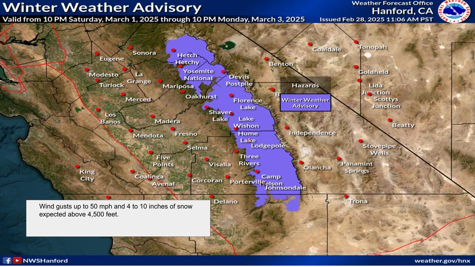
March 1, 2025 - National Weather Service Hanford Office officials report a Winter Weather Advisory has been issued from 10:00 P.M. Saturday, March 1 through 10:00 P.M. Monday, March 3 for the Sierra Nevada.
4 to 10 inches of snow is expected above 4,500 feet. Up to 14 inches of snow at highest elevations.
Wind gusts up to 50 mph in the Sierra Nevada
Winter Weather Advisory
URGENT - WINTER WEATHER MESSAGE
National Weather Service Hanford CA
257 AM PST Sat Mar 1 2025

CAZ323-326>331-011900-
/O.CON.KHNX.WW.Y.0002.250302T0600Z-250304T0600Z/
Yosemite NP outside of the valley-Upper San Joaquin River-Kaiser
to Rodgers Ridge-Kings Canyon NP-Grant Grove Area-Sequoia NP-
South End of the Upper Sierra-
Including the cities of Lake Wishon, Florence Lake, Lake Thomas
Edison, Devils Postpile, Huntington Lake, Shaver Lake, Tuolumne
Meadows, Hume Lake, Giant Forest, Lodgepole, Grant Grove,
Johnsondale, Wawona, and Cedar Grove
257 AM PST Sat Mar 1 2025

...WINTER WEATHER ADVISORY REMAINS IN EFFECT FROM 10 PM THIS EVENING
TO 10 PM PST MONDAY...

* WHAT...Snow expected. Total snow accumulations between 4 and 10
  inches above 4500 feet. Totals up to 14 inches at the higher
  elevations. Winds gusting as high as 50 mph.

* WHERE...A portion of central California.

* WHEN...From 10 PM this evening to 10 PM PST Monday.

* IMPACTS...Roads, and especially bridges and overpasses, will
  likely become slick and hazardous. Travel could be very difficult
  to impossible. The hazardous conditions could impact the Monday
  morning and evening commutes. Gusty winds could bring down tree
  branches.

PRECAUTIONARY/PREPAREDNESS ACTIONS...

Slow down and use caution while traveling. The latest road
conditions for the state you are calling from can be obtained by
calling 5 1 1.

Be prepared for slippery roads. Slow down and use caution while
driving. If you are going outside, watch your first few steps taken
on stairs, sidewalks, and driveways. These surfaces could be icy and
slippery, increasing your risk of a fall and injury.
Source: NWS