
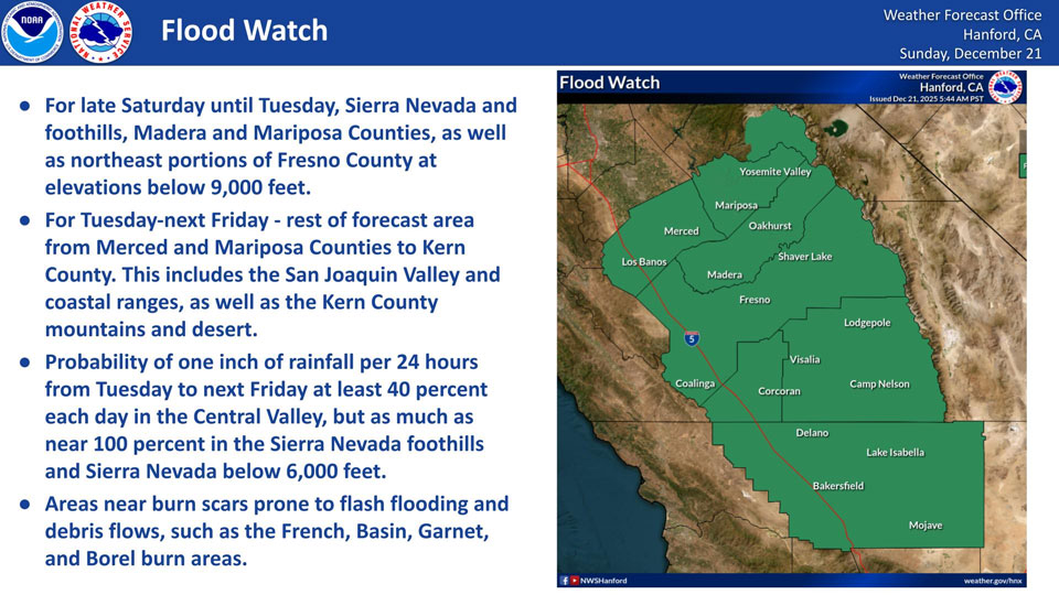
December 21, 2025 - National Weather Service Hanford Office officials report a Flood Watch is in effect for areas near Yosemite National Park to Fresno County in the Sierra Nevada and foothills below 9,000 feet until late next Friday.
Flood Watch also in effect for rest of our forecast area from late Tuesday until next Friday for elevations up to 6,000 feet.
Flood Watch
Flood Watch
National Weather Service Hanford CA
350 AM PST Sun Dec 21 2025

CAZ300>317-319>322-327>339-212000-
/O.CON.KHNX.FA.A.0013.251224T0000Z-251227T0000Z/
/00000.0.ER.000000T0000Z.000000T0000Z.000000T0000Z.OO/
West Side Mountains north of 198-Los Banos - Dos Palos-Merced -
Madera - Mendota-Planada - Le Grand - Snelling-Coalinga - Avenal-
West Side of Fresno and Kings Counties-Caruthers - San Joaquin -
Selma-Fresno-Clovis-West Side Mountains South of 198-Buttonwillow
- Lost Hills - I5-Delano-Wasco-Shafter-Hanford - Corcoran -
Lemoore-Visalia - Porterville - Reedley-Buena Vista-Bakersfield-
Southeast San Joaquin Valley-South End San Joaquin Valley-
Mariposa Madera Foothills-Fresno-Tulare Foothills-Fresno-Tulare
Lower Sierra-South End Sierra Foothills-South End of the Lower
Sierra-Kaiser to Rodgers Ridge-Kings Canyon NP-Grant Grove Area-
Sequoia NP-South End of the Upper Sierra-Kern River Valley-Piute
Walker Basin-Tehachapi-Grapevine-Frazier Mountain Communities-
Indian Wells Valley-Mojave Desert Slopes-Mojave Desert-
Including the cities of Selma, Auberry, Shaver Lake, Giant
Forest, Goshen, Merced, Lebec, Madera, Five Points, Camp Nelson,
Grant Grove, Kingsburg, Kettleman City, Wasco, Lodgepole,
Shafter, Rosamond, Corcoran, McKittrick, Lost Hills, Millerton
Lake, Avenal, Cedar Grove, Lemoore, Coalinga, Huntington Lake,
Hanford, Kernville, Lake Isabella, Bakersfield, Taft, Lamont, El
Portal, Edwards AFB, Atwater, Le Grand, Grapevine, Mojave,
California City, San Luis Reservoir, Kerman, Los Banos, Visalia,
Lemoore Station, Johnsondale, Parlier, Randsburg, Frazier Park,
Tulare, Ridgecrest, Sanger, Richgrove, Lake Mcclure, Lake Wishon,
Buttonwillow, Delano, Arvin, Inyokern, Porterville, Mariposa,
Blackwells Corner, Hume Lake, Tehachapi, Alpaugh, Planada, and
Fresno
350 AM PST Sun Dec 21 2025

...FLOOD WATCH REMAINS IN EFFECT FROM TUESDAY AFTERNOON THROUGH
FRIDAY AFTERNOON...

* WHAT...Flooding caused by excessive rainfall continues to be
  possible.

* WHERE...A portion of central California, including the following
  areas, Bakersfield, Buena Vista, Buttonwillow - Lost Hills - I5,
  Caruthers - San Joaquin - Selma, Coalinga - Avenal,
  Delano-Wasco-Shafter, Frazier Mountain Communities, Fresno-Clovis,
  Fresno-Tulare Foothills, Fresno-Tulare Lower Sierra, Grant Grove
  Area, Grapevine, Hanford - Corcoran - Lemoore, Indian Wells
  Valley, Kaiser to Rodgers Ridge, Kern River Valley, Kings Canyon
  NP, Los Banos - Dos Palos, Mariposa Madera Foothills, Merced -
  Madera - Mendota, Mojave Desert, Mojave Desert Slopes, Piute
  Walker Basin, Planada - Le Grand - Snelling, Sequoia NP, South End
  San Joaquin Valley, South End Sierra Foothills, South End of the
  Lower Sierra, South End of the Upper Sierra, Southeast San Joaquin
  Valley, Tehachapi, Visalia - Porterville - Reedley, West Side
  Mountains South of 198, West Side Mountains north of 198 and West
  Side of Fresno and Kings Counties.

* WHEN...From Tuesday afternoon through Friday afternoon.

* IMPACTS...Excessive runoff may result in flooding of rivers,
  creeks, streams, and other low-lying and flood-prone locations.
  Flooding may occur in poor drainage and urban areas. Low-water
  crossings may be flooded.

* ADDITIONAL DETAILS...
  - http://www.weather.gov/safety/flood

PRECAUTIONARY/PREPAREDNESS ACTIONS...

You should monitor later forecasts and be alert for possible Flood
Warnings. Those living in areas prone to flooding should be prepared
to take action should flooding develop.
Source: NWS