
California and National Drought Summary for April 28, 2026
Summary
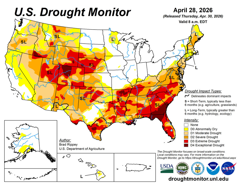
April 30, 2026 - Rain continued to bypass the central and southern High Plains, leaving rangeland, pastures, and winter wheat in desperate need of moisture. Farther east, however, showers and thunderstorms continued to ease drought across the eastern Plains, extending into the mid-South and Mississippi Delta. Some of the heaviest rain, accompanied by locally severe thunderstorms, fell from eastern Kansas into the lower Midwest. The remainder of the Midwest also received some precipitation, although some of the region’s wettest areas in the Great Lakes States got a break from the excessive rain that had led to pockets of record flooding earlier in the month. In contrast, much of New England and northern sections of New York were cool and dry. Elsewhere, unsettled, showery weather prevailed in the West, mainly north of a line from central California to the central Rockies, boosting topsoil moisture, delivering high-elevation snow, and reducing irrigation demands. However, any precipitation did not fundamentally change a mostly bleak Western water-supply outlook for the remainder of the spring into the summer of 2026.
Northeast
With a cool, mostly dry pattern in place, many areas experienced status quo or slowly worsening conditions. Notably, abnormal dryness (D0) and moderate drought (D1) expanded across southern New England and neighboring areas. An exception to the worsening conditions included parts of northern and eastern Maine, where improving groundwater led to a change from D1 to D0.
Southeast
In recent weeks, the Southeast has become “ground zero” for some of the worst drought in the country. According to the U.S. Department of Agriculture, statewide topsoil moisture in agriculture regions was rated 97% very short to short on April 26 in Georgia and South Carolina. On the same date, topsoil moisture was 88% very short to short in Virginia, along with 81% in North Carolina. Wildfires continued to burn in various parts of the Southeast, with the two largest having collectively burned more than 50,000 acres of vegetation in southern Georgia. Notably, the destructive Highway 82 fire in Brantley County, Georgia, has not only scorched more than 22,000 acres, but has also destroyed more than 100 homes. Broad drought deterioration was observed again this week in the Southeast, including further expansion of all categories, including extreme to exceptional drought (D3 to D4).
South
Late in the drought-monitoring period, significant rain overspread portions of the South, resulting in broad reductions in drought intensity. Some of the heaviest rain fell from eastern sections of Oklahoma and Texas into portions of Arkansas, Mississippi, and northern Louisiana. Still, more rain will be needed to ensure full drought recovery, since many of the hardest-hit areas had slipped into extreme to exceptional drought (D3 to D4) in recent weeks. Meanwhile, western sections of the South—including western Oklahoma and western Texas—remained critically dry, leading to poor rangeland, pasture, and winter wheat conditions, as well as a chronically elevated wildfire threat. Statewide, winter wheat in Texas was rated 56% very poor to poor on April 26, along with 45% in Oklahoma.
Midwest
Heavy precipitation in western and southern sections of the region led to further reductions in drought coverage. In fact, portions of the Great Lakes States have turned quite wet in recent weeks, with statewide topsoil moisture in agricultural regions rated by the U.S. Department of Agriculture as 48% surplus on April 26 in Wisconsin, along with 42% in Michigan. The 5-year average planting pace for sugarbeets in Michigan by April 26 is 51%, but due to this year’s wetness, only 3% of the crop had been planted this year on that date.
High Plains
Precipitation delivered drought relief to some areas, including parts of southern South Dakota and eastern sections of Nebraska and Kansas. Still, by April 26, topsoil moisture—as reported by the U.S. Department of Agriculture—was rated at least 40% very short to short in all the region’s states, except North Dakota, and led by Colorado (95%). Winter wheat continued to struggle due to drought and recent freezes, with 65% of Nebraska’s crop rated in very poor to poor condition on April 26, along with 54% in Colorado and 41% in Kansas. Drought continued to generally worsen in eastern Colorado and western sections of Kansas and Nebraska.
West
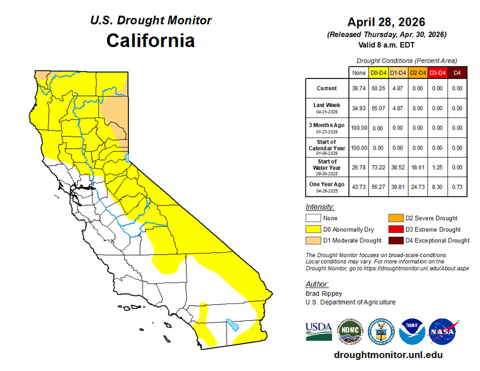
Any changes in the West were mostly minor and mixed, as cooler weather prevailed and spotty precipitation occurred. In most areas, Western precipitation did not alter bleak water-supply prospects, since most of the mountain snowpack has already melted, except in the northern Rockies. Already in late April, fears of an hydroelectricity generation crisis in the Colorado River Basin have led the Department of Interior to start sending water from Flaming Gorge Reservoir downstream to Lake Powell to help boost water levels. The Department of Interior also indicated that water normally destined for Lake Mead, farther downstream, would be held in Lake Powell. Despite overall lack of impact on Western supplies, any precipitation was largely welcomed, due to positive impacts such as a boost in topsoil moisture and a reduction in irrigation demands. In fact, enough precipitation has recently fallen to warrant a slight reduction in drought intensity in a few areas, including parts of western Colorado, northeastern Oregon, and southeastern Washington.
Caribbean
In Puerto Rico, neither dryness nor drought was observed anywhere across the commonwealth for a sixth consecutive week.
Each of the islands remains free of drought and dryness this week. CoCoRaHS stations across St. Croix Island recorded anywhere from 0.11” to 1.02” this week. St. John Island recorded anywhere between 0.37” and 0.66” of rain this week. The Windswept Beach station recorded 0.63” of rain this week. St. Thomas Island had received 0.41” of rain this week from CoCoRaHS stations. The Adventure 28 Well recorded water depth of 20.54 ft. as of this week. This is 0.04 ft. lower compared to last week and 3.36 ft. lower compared to last year. The Susannaberg DPW 3 Well recorded a water depth of 13.2 ft. as of this week. This is 0.11 ft. lower compared to last week and 3.43 ft. lower compared to last year. The Grade School 3 Well has a water depth of 5.92 ft. as of this week. This is 2.48 ft. lower than last week and 1.07 ft. lower compared to last year.
Pacific
In Alaska, two areas of abnormal dryness (D0) remained intact. However, the northwestern edge of Alaska’s southern D0 area was slightly trimmed amid widespread precipitation.
In Hawaii, there was some further reduction in the Big Island’s coverage of abnormal dryness (D0) and moderate drought (D1), as drought-related impacts continued to wane in the wake of an extremely stormy spell in March and early April.
Rain was plentiful across the Republic of the Marshall Islands (RMI). The islands of Jaluit, Mili, and Utirik received adequate rainfall, receiving 3.76”, 5.05” and 2.28” of rain this week. Other places, such as Ailingalapalap, Kwajalein, Majuro and Wotje received 1.34”, 1.28”, 1.71”, and 1.6” respectively. Nevertheless, each island remains free of drought and dryness.
Abnormal dryness has expanded to several islands across the Federated States of Micronesia (FSM). Ulithi and Yap will be receiving 1-category degradation to abnormal dryness. A combination of inadequate precipitation and dry grasses contributed to the degradation. Both Ulithi and Yap received 1.13” and 1.5” of rain this week, respectively. Woleai remains free of drought and dryness, but given that it received 0.61” of rain, this island might receive a 1-category degradation should inadequate rainfall continue next week. Lukunor remains in abnormal dryness, receiving only 0.09” of rain this week. Other islands in the FSM received plentiful rain. Kapingamarangi, Kosrae and Nukuoro received 3.71”, 7.8” and 2.85” of rain this week. Chuuk Lagoon received 1.24” of rain this week but will remain free of drought and dryness this week.
The Republic of Palau will receive a 1-category degradation to abnormal dryness. Monthly precipitation totals across the island are at the lowest recorded for the month of April. Koror has received 0.36” of rain this week and has received 1.73” for the month. Additionally, the WSO in Palau received 0.3” of rain this week and has received 1.15” of rain for the month.
The Marianas Islands continue to experience the impacts of the typhoon that passed in the middle of the month. Due to this, precipitation measurements are either missing or low and may have exposure issues. Due to this, each of the islands will maintain last week’s categories and will remain free of drought and dryness. American Samoa experienced a dry week, with Pago Pago receiving 0.77” of rain. Additionally, the Siufaga and Toa Ridge received 0.97” and 0.43” of rain this week, respectively. American Samoa will remain free of drought and dryness.
Looking Ahead
During the next several days, active weather across the South should lead to 1- to 4-inch rainfall totals from much of Texas to the southern Atlantic States. However, some Southern thunderstorms may produce large hail, damaging winds, and isolated tornadoes. The moisture will have a sharp northern edge, with little or no precipitation expected during the next 5 days across the northern and central Plains and Midwest. Generally dry weather will also cover the West, aside from late-season snow in the central and southern Rockies. Elsewhere, a cool pattern across the nation’s mid-section will strengthen, with frost and freezes possible into the weekend across the northwestern half of the Plains into the upper Midwest. By Saturday morning, scattered frost could extend as far south as the Ohio Valley and the southern High Plains.
The NWS 6- to 10-day outlook for May 5 – 9 calls for the likelihood of cooler-than-normal conditions in most areas east of the Rockies, while warmer-than-normal weather will be confined to an area stretching from the Pacific Coast to the northern Rockies, including the Great Basin and northern Intermountain West. Meanwhile, near- or below-normal precipitation from the Pacific Northwest into the upper Midwest should contrast with the likelihood of wetter-than-normal conditions across the remainder of the Lower 48 States.
Author(s):
Brad Rippey, U.S. Department of Agriculture
Daniel Whitesel, National Drought Mitigation Center
Dryness Categories
D0 Abnormally Dry—used for areas showing dryness but not yet in drought, or for areas recovering from drought.
Drought Intensity Categories
D1 Moderate Drought
D2 Severe Drought
D3 Extreme Drought
D4 Exceptional Drought
Drought or Dryness Types
S Short-term, typically less than 6 months (agriculture, grasslands)
L Long-term, typically more than 6 months (hydrology, ecology)
SL Area contains both short- and long-term impacts
Source: National Drought Mitigation Center