

Higher-than-normal sea surfaces (red) are visible in the central and eastern Pacific on June 8, 2026, a few days before El Niño was declared. Data for the map were acquired by the Sentinel-6 Michael Freilich satellite and processed by scientists at NASA’s Jet Propulsion Laboratory (JPL). NASA Earth Observatory/Lauren Dauphin
Experts from UC San Diego’s Scripps Institution of Oceanography weigh in on what to know about this event
October 21, 2026 - By Lauren Fimbres Wood - You’ve likely heard about El Niño, but what does that mean?
El Niño is a climate pattern that is declared when monthly sea-surface temperatures in the central and eastern tropical Pacific Ocean are measured above normal, for consecutive overlapping three-month periods. In early October, the National Oceanic and Atmospheric Administration (NOAA) announced an 83% chance that a strong-to-very-strong El Niño would arrive January through March 2027.
El Niño’s effects can be powerful and even deadly. El Niño-driven ocean warming can increase global temperatures, alter atmospheric patterns, raise sea levels along coastlines, deliver large waves and dangerous coastal conditions, and impact marine ecosystems.
1. This year’s El Niño is expected to be among the strongest ever recorded.
NOAA declares an El Niño when temperatures at the equator of the Pacific Ocean are 0.5°C (0.9°F) above average for several consecutive months. Temperatures are currently tracking 4.0°C (7.2°F) above normal. That big difference takes this event from a moderate event to a potentially historic event that exceeds the strength of all previous El Niño events that have been tracked since the 1950s.
2. The planet will likely hit a new global temperature record this year.
According to Scripps Oceanography climate scientist Alexander Gershunov, El Niño is a natural pattern, but it’s occurring in an unnaturally warming world.
“With a boost from El Niño, it’s almost certain that we will set a new global temperature record this year,” said Gershunov.
The extra heat from El Niño directly impacts and amplifies regional heat wave activity around the world, adding to the extreme heat already experienced in many areas this summer. This included the fatal heat waves across India, which were caused by the late arrival of monsoon rain, which is an early signature of El Niño’s arrival.
3. This El Niño is arriving on top of a record-breaking marine heat wave.
"With a boost from El Niño, it’s almost certain that we will set a new global temperature record this year."
The U.S. West Coast has been experiencing high ocean temperatures along the coast and offshore since late last year. This existing ocean warming means that the warm waters of El Niño will arrive on top of an already cooking Pacific Ocean.
Monitoring programs led by Scripps have been tracking this record-breaking warming. At Scripps Pier, the Shore Stations Program which takes a daily water sample to measure temperature and other variables, has thus far measured 53 days in 2026 with record daily highs over 110 years of recordkeeping. Up the coast in Santa Barbara, 71 days have had daily record temperatures in 70 years of records.
The Coastal Data Information Program (CDIP) managed by Scripps maintains a network of wave buoys offshore. The Torrey Pines buoy has had more than 80 days of record daily sea-surface temperature measurements in 2026, with other Southern California buoys measuring a similar warming trend.
Moving farther offshore, spray gliders — torpedo-looking instruments that navigate offshore and at depth along pre-programmed routes — are seeing the highest temperatures offshore that have been measured in 20 years.
This means ecosystems stressed by the marine heatwave will have even more warmth hit the system as El Niño-driven warmth arrives.
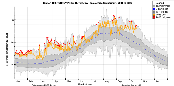
The Coastal Data Information Program Torrey Pines buoy has measured more than 80 days of record daily sea-surface temperatures in 2026 with more than 24 years of data.

4. El Niño raises sea level across the eastern Pacific Ocean, and the West Coast is already seeing record-high sea levels.
Strong El Niño conditions can raise sea level on the California coast by 15 to more than 30 centimeters (6 to more than 12 inches), and many of the highest sea levels in historical records have occurred during El Niño years.
Along the California coast, scientists are already seeing record-high sea levels. In La Jolla, for example, in September the tide gauge at Scripps Pier recorded the highest monthly mean sea levels ever recorded on the tide gauge. Similar increases in tide levels are also being reported statewide, driven by a combination of long-term sea level rise, the marine heat wave, and El Niño conditions.
“Currently sea levels are about a foot higher than normal, so this El Niño event is already having impacts on our coastline,” said coastal geomorphologist Adam Young during an El Niño briefing at Scripps. “The higher water levels allow waves to reach farther inland and increase the potential for coastal flooding and hazards.”
5. Big waves, increased sea level and storm activity can wreak havoc on the coastline.
El Niño conditions can generate a triple threat for coastal hazards in California. Increased rainfall triggers landslides; powerful waves can accelerate erosion of beaches, sea cliffs, and bluffs, and cause coastal flooding; and strong El Niño conditions raise sea level on the coast. The increased coastal erosion and flooding can threaten public parks, beaches, critical infrastructure, highways and homes.
However, timing matters. If large waves arrive during a very high tide, the potential for coastal flooding and other types of damage increases significantly, says Young. Multiple sequential storms can also be a factor. The first storm may strip all the sand off a beach, and without the natural sand buffer, the next storm can deliver a stronger punch.
Typically, coastal wave buoys maintained by the Coastal Data Information Program document high surf beginning to appear in late autumn and early winter during El Niño. This summer, however, CDIP measured record south-swell waves across California between Cape Mendocino and Oceanside, more than twice the average for June. These energetic waves from the south led to dramatic beach retreat and coastal damage at a number southwest-facing beaches prone to summer swell erosion and flooding.
Additionally, in an unlucky coincidence, California will see exceptionally high tides in late 2026 and early 2027. According to Scripps Professor of Physical Oceanography Mark Merrifield, very high tides can be expected around October 24, November 24, December 24, January 22 and February 19.
If winter storms with large waves landfall during these high astronomical tides, this excess will exacerbate flooding and damage to infrastructure along the coast. This compound hazard is one of the biggest worries this winter, according to scientists. Looking back at the 1982-83 El Niño, high tides converged with massive winter storms and El Nino-inflated sea levels, inflicting widespread and costly damage to structures along the West Coast.

6. El Niño makes storms more likely to hit Southern California, but rain is not guaranteed.
Every year there is a winter activation of storminess across the North Pacific, but El Niño years tend to have more numerous, southward-shifted winter storms. This causes more storm exposure in Southern California and northern Baja Mexico, along with a vigorous track across the southern tier of the U.S.
“We’re keenly interested in this 2026-27 strongly developing El Niño because some previous strong cases, like the massive events in 1982-83 and 1997-98, were among the stormiest and wettest years on record in California,” said Scripps climate scientist Daniel Cayan. However, the connection between El Niño and Southwestern precipitation has waxed and waned over the historical record and has been weak in recent decades, according to recent research from Scripps, making it especially challenging to forecast. For example, the 2015-16 El Nino was one of the strongest on record but was drier than an average year.
“This means that the wetter El Niño and drier La Niña pattern in the Southwest is a typical pattern, but it does not occur consistently in every period or every El Niño/La Niña event,” said postdoctoral scholar Rosa Luna Niño, who led the research.
Scientists across Scripps emphasize that wet El Niño years are likely, but not guaranteed.
“The declaration of an El Niño doesn’t guarantee that Southern California is going to have a wet, stormy winter, but it does stack the deck in that direction,” said Julie Kalansky, climate scientist and deputy director of operations at the Center for Western Weather and Water Extremes.
The amount of rain that arrives or doesn’t will also depend on the presence or absence of atmospheric rivers, the long, narrow bands of water vapor that carry moisture from the tropics. Atmospheric rivers are the main drivers of precipitation along the U.S. West Coast — they can mean full reservoirs if they arrive or send California into drought if they never come. Research from Scripps is also showing that the absence of atmospheric rivers can disrupt the typical El Niño wet winter.
Either way, forecasters say it’s best to prepare for a rainy winter.
“The declaration of an El Niño doesn’t guarantee that Southern California is going to have a wet, stormy winter, but it does stack the deck in that direction.”
7. El Niño shakes up the marine ecosystem, with species changing their range to find cooler, more nutrient-dense or more oxygen-filled water.
El Niño often reduces coastal upwelling, which is an important source of nutrients for the plankton at the base of the food web. The warm waters from El Niño also cause shifts as marine organisms adjust their range to seek cooler waters. These shifts can have negative consequences for some species, especially seabirds.
“Due to less food availability, marine predators, like seabirds, can’t find enough food, which leads to decreased body condition, reproductive stress, and increased mortality,” said marine ornithologist Tammy Russell. “The decrease in ecosystem production will disproportionately affect species with constrained diets and/or distributions. Species unable to shift their diet to other prey or those that can’t travel as far to forage will likely be hit the hardest.”
With the ecosystem shift, what species might we see in Southern California? According to Scripps scientists, it’s expected that tropical species will move north. So far this year, there have been reports of whale sharks, hammerhead sharks, oceanic manta rays, orcas and pilot whales, all not typical for the region. Some of these marine mammals may be driven to follow their prey.
“Whales, dolphins, seals and sea lions generally respond less to the temperature itself than to the way El Niño reorganizes the marine food web,” said Professor of Biological Oceanography Simone Baumann-Pickering. “Changes in upwelling and ocean circulation can alter where plankton, fish and squid occur, and marine mammals may consequently shift their distribution, migration timing or foraging behavior.”
8. El Niño is devastating for giant kelp forests in Southern and Baja California.
Giant kelp (Macrocystis pyrifera) forests in Southern California and Baja California, Mexico, have adapted to survive in cool, nutrient-rich waters. During El Niño years, they are exposed to warmer temperatures and less nutrient-filled waters from the lack of upwelling. Storm tracks that tilt more towards Southern California also expose kelp forests to more damaging winter swells that can upend kelp from the seafloor.
Already, scientists are seeing negative impacts to the La Jolla kelp forest. The Smith Seaweed Ecology Lab led by Jennifer Smith has been out tracking the health of the kelp forest during ongoing surveys as they prepare for experimental kelp forest restoration research.
“Unfortunately, there is not a lot of kelp at the moment,” said Smith, during the Oct. 7 El Niño briefing. “We have been seeing tremendously warm water, and not seeing a lot of upwelling. Even on the bottom — 50 feet below— the water has been 70 degrees. When kelp is exposed to warm water for extended periods of time, it dies. Given the lack of upwelling, there is also no nitrogen and phosphorus, which kelp need to grow, so the ability for kelp to persist under current conditions is significantly reduced.”
Scientists fear that this very strong El Niño will further stress kelp forests that have only partially recovered since the last El Niño. Ed Parnell, a marine biologist who has tracked kelp forests in the San Diego region for decades, gave a grim prediction.
“I am greatly concerned that with continued ocean warming and the increased likelihood of severe and possibly more frequent El Niños, much of Southern California’s kelp canopy could disappear within my kids’ lifetime,” said Parnell.

Scripps Oceanography PhD candidate Mohammad Sedarat conducts a scuba survey of a kelp forest near Catalina Island. Sedarat and the Smith Seaweed Ecology Lab conduct quarterly scuba surveys of La Jolla kelp forest monitoring sites. Credit: Jeff Hester/Scripps Institution of Oceanography.
9. There are some ecosystem winners during El Niño.
Not all species are impacted negatively by El Niño — for some, it expands their range.
“When upwelling is reduced by El Niño, oxygen levels in the middle depths can increase, which allows species that need a lot of oxygen like tuna to move into those depths and find more food,” said Colleen Petrik, assistant professor of biological oceanography. “Tuna do quite well during El Niño years because they can expand their range horizontally into the eastern Pacific and vertically into these deeper waters that normally don’t have enough oxygen.”
The California Cooperative Oceanic Fisheries Investigation (CalCOFI) has done quarterly surveys of the California current for the last 77 years. Looking at the last combined El Niño and marine heatwave that happened between 2014-16, anchovy increased from record lows to record highs, according to CalCOFI project scientist Rasmus Swalethorp.
“This provided a robust food source for many species that eat anchovy, including adult sea lions and large fish like tuna,” said Swalethorp. “Rockfish also did really well during this last big El Niño, which has helped them further recover from overfishing over the past 20 years.”

A trawl net used to collect juvenile fishes is deployed during a CalCOFI expedition. Image credit: James Wilkinson.
10. El Niño can affect the global economic output by trillions of dollars.
The increases in rain that typically come from El Niño can lead to damaging flooding. A study on the economic impacts of El Niño on flooding in the western U.S. led by Scripps scientists Daniel Cayan and Tom Corringham found that damages in Southern California were 10 times greater in El Niño winters than in La Niña winters over the 40-year period from 1978–2017.
According to Corringham, a climate economist, beyond flooding, El Niño affects agriculture, fisheries, wildfire, energy and economic growth around the world. It also changes crop yields and global food prices. A recent economic study estimated that the strongest El Niño events can ultimately affect global economic output by trillions of dollars.
To prepare for El Niño, Corringham has several practical recommendations, which he shared during the El Niño briefing. He recommended people look at their residence using the map service center produced by the National Flood Insurance Program to see if they are in a flood zone. He also cautioned that typical homeowners insurance does not cover floods that come from outside caused by rain.
“It might cover a broken pipe inside your house, but not flooding,” said Corringham. “Homeowners should check their policy if they’d like to make updates, especially if they are in an area prone to flooding.”
Additional information on El Niño can be found in the Scripps Institution of Oceanography El Niño Resource Hub.
Related content
Dive Deeper on El Niño
What is El Niño and what makes this a very strong El Niño?
How does El Niño impact the weather?
How does El Niño impact ocean ecosystems?
How does El Niño impact the California coast?
El Niño and San Diego: What to Expect (video briefing)
Learn more about research and education at UC San Diego in: Climate Change
Source: UC San Diego