


Empire Fire in Yosemite National Park
Note: Click Here for Monday's Information on the Empire Fire in Yosemite National Park
Lightning-caused wildfires are a common occurrence. There have been a total of 10 lightning-caused wildfires since July 31, 2017. One fire currently in monitor status is the Empire Wildfire. Which is currently being managed for resource and protection objectives.
Monitoring a wildfire is a fire management tactic used by fire managers when strategizing an incident response, and contributing factors that help steer this decision-making process are often incident specific. Location, available resources, predicted weather, topography, air quality and predicted fire behavior are all factors that contribute to fire management decisions.
As of Tuesday Morning: 1,320 Acres
Location: N 37° 38' 40" x W 119° 37' 6"
at approximately 7300 feet elevation
Discovery Date: July 31st, 2017
Size: 1320 acres Cause: Lightning
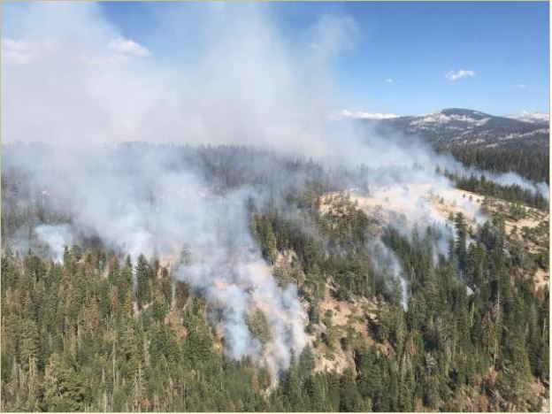
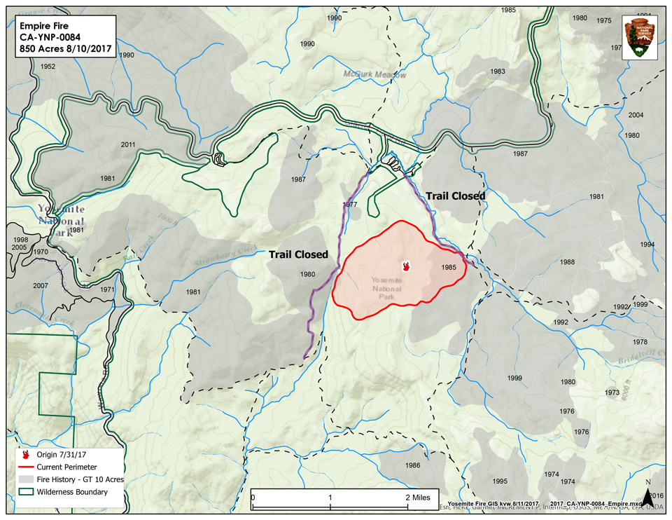
The Empire Fire is being managed for both resource and protection objectives. It is approximately 1 mile south of the Bridalveil Campground east of Alder Creek drainage and west of Bridalveil Creek drainage, burning in Red fir. Fire behavior has been actively flanking and backing with some single and group tree torching. The fire is burning in heavy pockets of dead and down timber, reducing fuels buildup which increases forest resiliency. Projected fire growth is expected in the northeast and southeast flanks.
The affected area is in a fire-adapted wilderness. Allowing fires to burn naturally can result in healthier, more diverse ecosystems. Reducing fuels buildup minimizes the potential for future severe fires. Although the current fire may have transient, moderate smoke impacts, more severe fires can cause unhealthy levels of smoke for extended periods, over a much wider area.
Trails are closed from Bridalveil Creek Campground at the second junction with the Ostrander trail and from Westfall Meadow to the Deer Camp junction, along Alder Creek. There are no threats to infrastructure at Bridalveil Campground and the remainder of hiking trails in the area are open at this time. All trails will continue to be assessed by fire crews. Future closures will be decided based on fire behavior. Smoke will be seen in the fire area and may impact the Bridalveil Campground.
The fire will be visible from the high country and may be seen from multiple viewpoints in the immediate area off Glacier Point Road including Sentinel and Washburn Points.
Fire Managers are working with the local Air Quality Districts and will be monitoring smoke impacts to the park and local communities. Community members who are sensitive to smoke may want to close their windows and doors and monitor the air quality links below.
Basic Information
| Current as of | 8/14/2017, 5:59:41 PM |
|---|---|
| Incident Type | Wildfire |
| Cause | Lightning/natural |
| Date of Origin | Tuesday August 01st, 2017 approx. 08:45 AM |
| Location | 1 Mile South of Bridalveil Campground in Yosemite's Wilderness |
| Incident Commander | Stephen Grater ICT3 |
| Incident Description | Management |
Current Situation
| Total Personnel | 33 |
|---|---|
| Size | 1,320 Acres |
| Fuels Involved | Red Fir Timber (Litter and Understory), Dormant Brush, Hardwood Slash Pockets of green leaf manzanita and chinquapin brush as well as heavy dead and down material |
| Significant Events | Trails are closed from Bridalveil Creek campground to the second junction with the Ostrander trail. Additionally, from Westfall Meadow to the Deer Camp junction, along Alder Creek remains closed. Signs are placed at the affected trails. There are no threats at this time to infrastructure at Bridalveil Campground and the remainder of hiking trails in the area remain open at this time. |
Outlook
| Planned Actions | Continue to hold and improve existing trails and lines. |
|---|---|
| Projected Incident Activity | 12 hours: The southwest side of the fire continues to work it's way south along Alder Creek Drainage. 24 hours: Crews are checking fire spread at Alder Creek 48 hours: Same 72 hours: Continue to improve contingency lines along Alder Creek Trail |
Current Weather
| Weather Concerns | Little diurnal change in temperatures and humidities, winds will be light and terrain driven through this period. |
|---|
- Fire Information: Yose_Fire_Info@nps.gov
- Facebook: https://www.facebook.com/YosemiteNPS/
- Twitter: https://twitter.com/YosemiteNPS
- Air Quality: https://www.nps.gov/yose/learn/nature/aqmonitoring.htm and https://airnow.gov/index.cfm?action=airnow.local_city&mapcenter=0&cityid=533
For smoke and air quality information as it relates to both the Empire Fire and Butte Fire on the Sierra National Forest visit : https://wildlandfiresmoke.net/outlooks/2017/CentralSierraFires#Main

