


 Monday Evening Map (11:39 P.M.)
Note: Click here for Monday's information on the South Fork Fire in Yosemite National Park
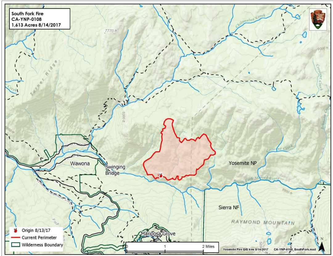
August 15, 2017 - The South Fork Fire began about Sunday morning at 2:30 A.M. The South Fork Fire is burning in the South Fork of the Merced River, 1 mile upstream from Swinging Bridge.
It is on a south south-west aspect in steep, rocky, inaccessible terrain.
The fire is burning in an area of heavy tree mortality due to bark beetle infestation and poor forest health. Due to the proximity of the community of Wawona, as well as the challenging terrain, the primary objective is firefighter and public safety.
Update: 9:40 A.M. Size: 1,613 acres 0% Containment
Location: N 37°32 '15" x W 119° 35'54" - approximately 5100' elevation
Discovered: 8/13/17 2:30 p.m.
Size: 1613 acres Containment: 0%
Cause: Unknown
Fuels: Ponderosa pine transitioning to White fir
Strategy: Suppression
County: Mariposa
The South Fork fire is burning 1.0 mile east of the community of Wawona upstream of Swinging Bridge in the South Fork of the Merced River drainage. The fire is burning in the wilderness but is being managed for protection objectives due to its close proximity to the community of Wawona.
The fire was discovered at 2:30 p.m. on August 13, 2017. Tactics in use include helicopter bucket work, retardant drops and tanker drops mainly on the left flank of the fire.
Strategic objectives are containment of the west flank and keeping the fire north of the river for protection of the community of Wawona. Air resources, hand crews and type 3 engines are all being utilized.
The fire is burning in dense mixed conifer forest with areas of heavy tree mortality. Most of the projected fire growth is expected on the north and northeast flanks of the fire which is burning into the wilderness and away from the community. However, the fire also continues to back down the South Fork drainage.
Smoke is expected to be heavy in the fire area and adjacent communities and is likely to be very dense in Wawona in the evenings and mornings. Visibility may be impacted along Wawona Road (Hwy 41 extension) south to Fish Camp, Glacier Point Road, Yosemite Valley, Hwy 140 from El Portal to Mariposa, and Tioga Pass to the Mono Lake area.
Portable and stationary particulate monitors are placed in areas that are most likely to see impacts of smoke during certain hours of the day. The local air quality districts use the data from these monitors to issue air quality alerts and notices. Fire Managers are working with the local Air Quality Districts and will be monitoring smoke impacts to the community of Wawona, park and local communities. Community members who are sensitive to smoke may want to close their windows and doors and monitor the air quality links below.
Additional Information
Rapid Notify is a community alert system for rapid event notifications. Register by visiting www.alert.rapid notify.com
Nixle is a public-safety notification system. Sign up for emergency alerts by texting 95389 to 888-777 or visit their website at www.nixle.com
- Fire Information: Yose_Fire_Info@nps.gov
- Facebook: https://www.facebook.com/YosemiteNPS/
- Twitter: https://twitter.com/YosemiteNPS
- Air Quality: https://www.nps.gov/yose/learn/nature/aqmonitoring.htm and https://airnow.gov/index.cfm?action=airnow.local_city&mapcenter=0&cityid=533
For smoke and air quality information as it relates to both the Empire Fire and Butte Fire on the Sierra National Forest visit : https://wildlandfiresmoke.net/outlooks/2017/CentralSierraFires#Main
Update: 6:40 P.M. Monday Evening - Size: 1,613 acres
Current acreage of the South Fork fire is 1613.
The fire is burning 1 mile east of the community of Wawona, upstream of Swinging Bridge in the south fork of the Merced river drainage.
Hand crews and air resources used suppression tactics on the western flank of the fire.
Fire behavior today consisted today of group tree torching, uphill runs and short range spotting in dense mixed conifer forest with heavy tree mortality.
Smoke is expected to be heavy in fire area and adjacent communities. It is likely to be dense in Wawona in the evenings and mornings. Visibility may be impacted along Wawona Road, Glacier Point Road, Yosemite Valley and Tioga Pass. There are trail closures in effect locally. Please observe all posted trail closure signs.
Basic Information
| Current as of | 8/14/2017, 6:40:25 PM |
|---|---|
| Incident Type | Wildfire |
| Cause | Unknown |
| Date of Origin | Sunday August 13th, 2017 approx. 02:30 AM |
| Location | 1.5 miles east of the community of Wawona |
| Incident Commander | Jeff Pirog |
| Incident Description | Supression |
Current Situation
| Total Personnel | 148 |
|---|---|
| Size | 1,613 Acres |
| Fuels Involved | Timber (Litter and Understory) Brush (2 feet) |
| Significant Events | Group tree torching, Uphill Runs, Short-Range Spotting |
Outlook
| Planned Actions | Continue to utilize air resources and tie fire into natural barriers. Assess need for trail closures. |
|---|---|
| Projected Incident Activity | 12 hours: Continue to aggressively suppress fire spread toward community of Wawona on west flank of fire. Camp Wawona and homes on Chilnualna Falls Ridge, voluntary evacuation. 24 hours: Prepare community for potential evacuations. 48 hours: Direct line construction on west edge of fire and actively monitor potential spread to avoid fire getting south of the South Fork of the Merced river. Aggressively suppress any spot fires in that area. 72 hours: Secure south edge of the fire and keep contained to South fork of Merced, secure west flank. Priority is protection of life and property of Wawona and Mariposa Grove of Giant Sequoias |
South Fork Fire August 13th 2017
