


Statistics
California and National Drought Summary for February 13, 2018
Summary
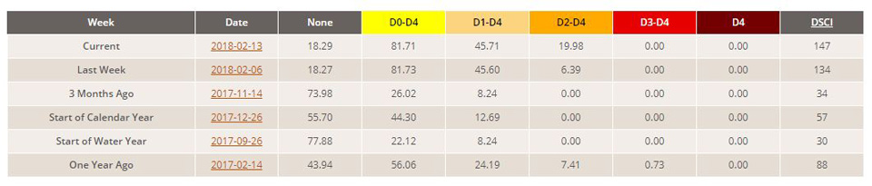
February 15, 2018 - During the 7-day period (ending Tuesday morning), heavy to excessive rainfall eased or eliminated dryness and drought across much of the eastern, southeastern, and southcentral U.S. Conversely, drought intensified and expanded from the central Corn Belt southwestward across the southern Plains into the Southwest, including much of southern California. Other modest changes to the nation’s drought depiction over the past 7 days included reductions to drought intensity in Montana as a result of recent snowy, cold weather, while dryness and drought expanded in Oregon due in large part to subpar snowpacks.
Northeast
For the second consecutive week, soaking rainfall (1-2 inches, locally more) eased or eliminated lingering drought concerns in eastern portions of the region. In New England, rain was sufficient to eradicate the lingering Abnormal Dryness (D0) areas, with 90-day precipitation near to above normal. Farther south, 2 to 5 inches of rain during the period was more than enough to eliminate Severe Drought (D2) and similarly reduce Moderate Drought (D1) across Pennsylvania and Maryland. Where rain was heaviest (4 inches or more, with two-week totals locally as high as 6 inches), 2-category reductions to drought were made. Nevertheless, 90-day precipitation deficits (50-70 percent of normal) persisted in the remaining D0 and D1 areas, with slow-to-recover groundwater levels still the greatest impact of this winter’s drought.
Southeast
Widespread heavy rainfall netted considerable reductions in drought intensity and coverage across the Southeast during the period. Outside of southern- and eastern-most portions of the region, rain totaled 2 to 6 inches (locally as much 10 inches in the Florida panhandle), with widespread 2-week totals of 4 to 8 inches. As a result, Moderate, Severe, and Extreme Drought (D1, D2, and D3, respectively) were reduced or eliminated from Virginia to the Gulf Coast. The 2-category reductions corresponded to rainfall of 4 to 10 inches and no corresponding sign of lingering deficits out to 90 days. Despite the excessive wetness, 90-day precipitation remained 50 to 70 percent of normal in the lingering D1 areas, although these locales have nevertheless seen drought conditions relax due to the recent rain.
South
For the second consecutive week, moderate to heavy rain in eastern portions of the region contrasted with intensifying drought across the southern Plains and environs. Rainfall totaled 2 to 6 inches from eastern Texas into Tennessee, with two-week totals of 6 inches or more in east-central Mississippi. The net result was a widespread reduction of Abnormal Dryness (D0) and Moderate to Severe Drought (D1 and D2). Despite the moisture, longer-term deficits persisted in the Delta’s core D1 area, with 90-day precipitation 50 to 70 percent of normal (locally less). Farther west, Extreme Drought (D3) expanded further across northern Texas, with even more notable increases in D2 in central Texas. The drought situation remained unchanged in Oklahoma, with rain sorely needed as warmer weather begins to stimulate the growth of crops and vegetation. From Lubbock, Texas, northward into Oklahoma, little — if any — precipitation has fallen over the past 90 to 120 days; the four-month Standardized Precipitation Index (SPI) was well below D4 levels (-2.0 or lower, with some below -3.0) in these locales. The lack of rainfall is affecting winter wheat, pastures, pond levels, and streamflows. Impacts will rapidly escalate if rain does not materialize soon. To put the dryness in perspective, February 14th marked the 124th consecutive day without rain in Amarillo, shattering the previous mark of 75 days (records date back to 1892). In Lubbock, February 14 marked the 98th consecutive day without measurable precipitation, tying the record. Other notables in Texas include Plainview and Memphis, which are both now at 130 days without measureable precipitation. Similar statistics are emanating out of Oklahoma, where Woodward and Laverne just reached 127 days without measureable precipitation as of February 14. The situation on the southern Plains is rapidly becoming dire, and precipitation will be needed soon to prevent further expansion or intensification of drought.
Midwest
Cold weather prevailed, with a swath of welcomed snowfall in central portions of the region contrasting with intensifying drought to the south. From Iowa into southern Michigan, widespread snow (4-12 inches, locally more) boosted moisture prospects, with a liquid equivalent 0.5 inch to locally more than an inch. As a result, there were modest reductions to Abnormal Dryness (D0) in parts of Iowa, southwestern Minnesota, and east-central Wisconsin. Meanwhile, drought continued to intensify from southeastern Missouri into southern Illinois and west-central Indiana. Dryness was most pronounced across eastern Missouri and neighboring portions of Illinois, where 6-month precipitation has averaged a meager 25 to 50 percent of normal (deficits of 8 to 12 inches). In these locales, Severe and Extreme Drought (D2 and D3) were
expanded. Similarly, 2- to 4-inch deficits over the past 90 days (less than 50 percent of normal) were noted in the newly-expanded Moderate Drought (D1) and D0 areas of east-central Illinois and west-central Indiana.
High Plains
Additional snow in central portions of the region contrasted with dry conditions elsewhere. There were no changes made to the drought depiction in the Dakotas, where a lack of snowfall to date has led to declining prospects for spring meltoff; resultant detrimental impacts on topsoil moisture and stock pond levels remained a primary concern. Meanwhile, a continuation of the recent snowy weather pattern in northeastern Colorado, southeastern Wyoming, northwestern Kansas, and much of Nebraska (30-day surplus of 1-2 inches, liquid equivalent) supported the reduction of Moderate Drought (D1) and Abnormal Dryness (D0). Likewise, moderate to heavy snow (depths averaging 12 to 24 inches, liquid equivalent 1 to 2 inches) in northeastern Montana supported some reduction of the state’s persistent long-term drought. Conversely, southern Kansas remained locked in the same drought which has held a firm, intensifying grip on the southern Plains. However, additional detailed assessment of data coupled with information from the field led to a minor adjustment of the Extreme Drought (D3) which slices over the south-central U.S., with the depiction shifted slightly east from southeastern Colorado into western Oklahoma to reflect the updated information.
West
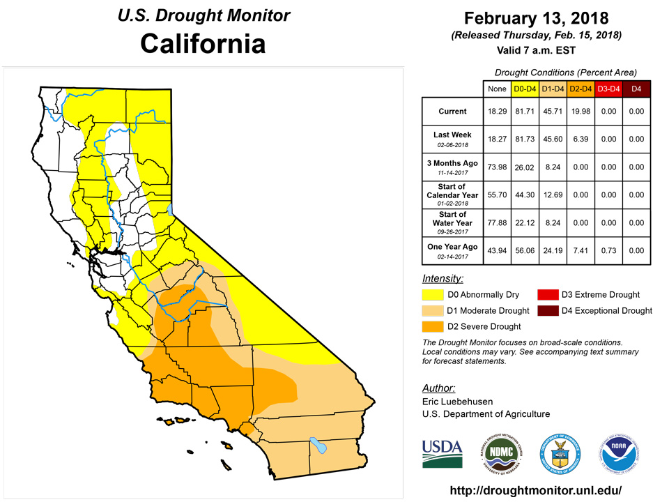
Outside of bitter cold, snowy weather in the northeastern corner of the region, warm and mostly dry conditions prevailed. In Montana, moderate to heavy snow (depths averaging 12 to 24 inches, liquid equivalent 1 to 2 inches) in northern and eastern portions of the state supported some reduction of the state’s persistent long-term drought. Meanwhile, an increasingly poor Water Year as well as historically low mountain snowpacks led to the continuation or expansion of dryness and drought. In southwestern Colorado, Severe Drought (D2) was expanded slightly to the northeast of the San Juan Mountains, as the southwestern corner of the state continues to wrestle with sub-par season-to-date precipitation (locally less than 25 percent of normal since October 1) and very poor mountain Snow Water Equivalent (SWE) for spring runoff. More notably, D3 was added in northern New Mexico where SWE’s are at or near 0. In fact, similarly abysmal SWE’s encompass much of the Four Corners States into northern Nevada and — to a lesser extent — the Sierra Nevada. The Drought Monitor and local experts will continue to closely monitor the snowpack situation over the upcoming weeks. Exacerbating the situation has been the very poor Water Year, with precipitation-to-date totaling less than 25 percent of normal over large tracts of southern California and the Southwest; Severe Drought (D2) was expanded accordingly to reflect the driest areas. Conditions also have begun to slip farther north as well. Moderate Drought (D1) was added to Oregon and northern Nevada, where precipitation during the current Water Year has slipped below 50 percent of normal and mountain SWE’s are in the 10th percentile or lower.
Alaska, Hawaii, and Puerto Rico
A wet weather pattern continued in Hawaii. Additional rainfall warranted the removal of D0 on Kauai, Molokai, and Maui. On the Big Island, the northern D1 was likewise improved to D0 over the upper elevations. The D0 area over the Mauna Loa and Kilauea slopes was reduced to cover just the leeward slopes. There were no changes made this week to the Abnormal Dryness depiction in Alaska. Puerto Rico remained free of Abnormal Dryness or drought.
Looking Ahead
An unsettled weather pattern will maintain periods of rain and snow over much of the nation, although pockets of dryness will persist. A series of storms will bring moderate to heavy rain and mountain snow to much of the west, although unfavorably dry conditions will persist from California into western Nevada. East of the Rockies, an active southern storm track will bring much-needed precipitation to locales from southeastern New Mexico across the southern two thirds of Texas into southern Oklahoma and the northern Delta. Despite the welcomed storminess, dry weather will linger from the south-central Plains into western Missouri as well as over the lower Southeast. Farther north, another round of moderate to heavy snow is expected from Montana into the Great Lakes and eastern Corn Belt, and may include the Mid-Atlantic as well as Northeastern States. The NWS 6- to 10-day outlook for February 20 – 24 calls for near- to above-normal precipitation over much of the nation, in particular areas east of the Mississippi save for Florida and the lower Southeast, where drier-than-normal conditions are expected. Below-normal precipitation is also anticipated in the Southwest and on the southern High Plains. Above-normal temperatures over the southern and eastern U.S. will contrast with colder-than-normal weather from the Pacific Coast States into the upper Midwest.
Author(s):
Eric Luebehusen, U.S. Department of Agriculture
Dryness Categories
D0 Abnormally Dry—used for areas showing dryness but not yet in drought, or for areas recovering from drought.
Drought Intensity Categories
D1 Moderate Drought
D2 Severe Drought
D3 Extreme Drought
D4 Exceptional Drought
Drought or Dryness Types
S Short-Term, typically less than 6 months (e.g. agricultural, grasslands)
L Long-Term, typically greater than 6 months (e.g. hydrologic, ecologic)
Source: National Drought Mitigation Center
