


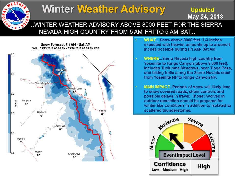
May 25, 2018 - The National Weather Service Hanford Office reports a Winter Weather Advisory for late season snow is in effect for the Sierra Nevada high country above 8,000 feet from Yosemite to Kings Canyon National Parks during Friday morning through Saturday morning.
 .SYNOPSIS...Low pressure will move across the area today and
  then move into Nevada on Saturday. Showers and thunderstorms
  are expected over the Sierra and parts of even the lower
  elevations of the north today. Weak high pressure will
  return by Sunday and Monday with a warming and drying
  trend.

  &&

  .DISCUSSION...GOES-16 water vapor imagery shows the center of the
  incoming Pacific system now about 150 miles west of Monterey.
  Associated jet stream is well noted pushing north/northeast into
  the Central California Interior and regional radars show bands of
  light rain extending into Merced County and increasing echoes of
  light showers to the south and east, now developing over Western
  Fresno County. Given the strong dynamics and the incoming low
  pressure system, showers and even a thunderstorm or two will
  becoming more widespread as we head through the late night hours
  from essentially Fresno County north. For today, forecast models
  bring the center of low pressure onshore in the Bay area and by
  later this afternoon and evening only slowly move the low center
  to the southeast.

  Given the low position and directional shear, expect quite a few
  thunderstorms over the Sierra and foothills with the threat
  extending into the San Joaquin Valley from basically Fresno
  County north through the afternoon and early evening. Meanwhile,
  over the Sierra, snow will likely fall to around 8000 feet as the
  colder air aloft associated with the low center arrives. The
  Winter Weather Advisory is certainly warranted as up to several
  inches of snow is possible with very cold and winter-like
  conditions for the hiking and high country enthusiasts.

  More showers and thunderstorms are likely on Saturday as the low
  moves into Nevada and cyclonic flow continues in the Sierra. Other
  areas will likely see any precipitation threat come to an end. On
  Sunday the low is progged to only move slowly east into western
  Utah and the last of the wrap around cyclonic flow lingers along
  the Sierra Crest for one last day of a thunderstorm threat. Models
  then build a weak ridge over the forecast area on Monday and
  Tuesday for a warming and drying trend. All in all a very cool and
  potentially stormy day today to start the Memorial Day Weekend
  however by Monday, warm and dry conditions will prevail.

  Next week looks to remain cooler than normal as yet another trough
  of low pressure develops offshore and then deepens to a closed low
  by Thursday.
Source: NWS

