


California and National Drought Summary for July 12, 2022
Summary
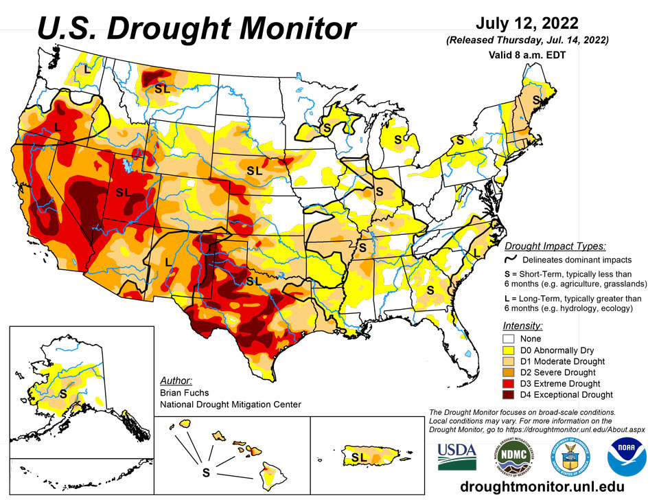
July 14, 2022 - An active weather pattern over much of the Midwest and Southeast brought with it ample rain over many areas, with some places recording more than 5 inches for the week. Dry conditions were noted in the Northeast, West, and southern Plains where flash drought conditions were impacting vast portions of Texas, Oklahoma, Arkansas and into the lower Mississippi River valley. Monsoonal moisture continued to be spotty over much of Arizona and New Mexico, reaching into portions of west Texas as well as southern Colorado and Utah. Temperatures were near normal to slightly above over most of the U.S., with cooler-than-normal temperatures over portions of the West, Northeast, and Mid-Atlantic and above-normal temperatures over most of Texas, Oklahoma, Arkansas, and southern Missouri.
Northeast
Cooler-than-normal temperatures dominated the region. Temperatures for the week were coolest along the northern portions of New York into Maine, where temperatures were 4-5 degrees below normal. Pennsylvania had the warmest temperatures, with departures of 1-2 degrees above normal. The dryness in the region has allowed for drought expansion this week with a new area of moderate drought in western New York and a new area of severe drought in eastern Massachusetts. Abnormally dry conditions were expanded over much of northern Pennsylvania and northern New Jersey and into southeastern New York. Moderate drought was expanded in Maine, New Hampshire, and Vermont. Abnormally dry conditions were adjusted in southern New Jersey and a new pocket of abnormally dry conditions was added to southern Delaware. Most of the dryness was short-term in nature, but there were immediate declines to river and streamflow levels throughout the region.
Southeast
Warmer-than-normal temperatures were observed over most of the region outside of the coastal areas of Virginia and into the Carolinas where temperatures were 2-4 degrees below normal. Elsewhere, temperatures were 2-4 degrees above normal, with the warmest readings in western Tennessee. Almost the entire region recorded rain this last week, with the driest areas being in south Florida as well as the panhandle. Throughout the region, precipitation of 200-400% of normal was common. The widespread heavy rains allowed for some easing of the dryness and drought conditions that were impacting the region. A full-category reduction of drought intensity and dryness was made over Virginia, North Carolina, South Carolina, and much of Georgia and northern Florida. Some areas of the region did not pick up substantial rains, which allowed for expansion of abnormally dry conditions in northern Alabama, eastern Alabama, western Tennessee and western Mississippi. A new area of severe drought was also added to western Tennessee where short-term conditions continue to deteriorate.
South
The region was mainly dry outside of some monsoonal moisture that made it into portions of West Texas and the panhandle. Portions of southwest Mississippi into southern Louisiana also benefited from above-normal precipitation this week. Some of the warmest temperatures in the country were observed in the region this week with many places having multiple days of triple-digit heat. Temperatures were 5-10 degrees above normal over much of the region as flash drought has developed. With the rapidly developing situation, without relief from the heat or precipitation, drought will continue to intensify rapidly. There were many changes to the drought intensity of the region this week, with only areas of west Texas and the panhandles of Texas and Oklahoma showing any improvements. Almost all of eastern Oklahoma, northern Texas, and Arkansas had a full-category degradation this week. Further degradation took place over central and southern Texas as well as portions of northern and western Louisiana. Coleman County, Texas had its driest January-to-June period on record going back to 1895. Other counties that had the driest first six months of the year were Bosque, Hamilton, Coryell, Wilson, Karnes, and Bee counties in Texas and Calcasieu Parish in Louisiana. There has been an uptick in the number of cattle sales taking place as water and feed demands are being impacted by the drought.
Midwest
Widespread precipitation over the region helped to stave off much expansion and intensification of drought in the region. Temperatures were coolest over the upper Midwest and Michigan, with temperatures that were 2-4 degrees below normal. The warmest area was in the southwestern corner of the region, where portions of southern Missouri were 4-6 degrees above normal for the week. Improvements were made from southern Minnesota to Kentucky where the greatest rains occurred, but where the rains missed, some degradation took place. Moderate drought and abnormally dry conditions expanded over southern Minnesota into western Wisconsin. Moderate drought expanded over central and southern Missouri as flash drought conditions have started to take hold over the last few weeks. Portions of northern Illinois, central Indiana and into southwest Ohio and northern Kentucky saw expansion of moderate drought and abnormally dry conditions. Two new areas of severe drought were introduced into western and central Kentucky this week too.
High Plains
Most of the region had warmer-than-normal temperatures for the week, with most areas 1-3 degrees above normal. Heavy rains through western North Dakota, central and eastern South Dakota, northwest and central Nebraska, and northeastern Kansas helped with some dryness in the areas. The scattered nature of the rains left many dry, though, as summer thunderstorms were hit or miss in the region. Some improvements were made in Nebraska and central Kansas as well as on the plains of Colorado and Wyoming this week where the short-term wetness helped to alleviate concerns. Degradation took place over central Wyoming, southern South Dakota and western Kansas where longer-term dryness has been in place and most of these areas have missed out on earlier precipitation events. Exceptional drought was removed in southeast Colorado and extreme drought was reduced this week. Southeast Kansas is an area where abnormally dry and moderate drought expanded this week, as they are on the northern fringe of a flash drought that has been developing over the last 4-5 weeks.
West
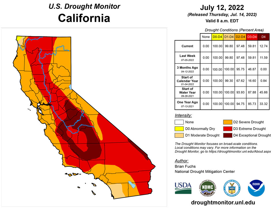
Cooler-than-normal temperatures prevailed from the Pacific Northwest into much of California and western Nevada, where temperatures were 1-3 degrees below normal. Much of the rest of the region was normal to slightly above normal for the week. Above-normal rains fell in portions of Oregon and Washington as well as in Montana. Monsoonal moisture continues in New Mexico and Arizona, but it is widely scattered in nature compared to earlier in June. The rains did allow for some improvement in areas of New Mexico, where extreme and severe drought were reduced, and western Arizona, where severe drought was reduced. Severe drought was improved in southwest Colorado and much of the drought area of Montana had a full-category improvement. Moderate drought and abnormally dry conditions were adjusted in Washington to show a mix of improvements and some expansion of moderate drought. Extreme and exceptional drought was expanded over central Nevada and exceptional drought was expanded to include more of the San Joaquin Valley in California.
Caribbean
On Puerto Rico, substantial rains over the northwest and northeast portions of the island allowed for a reduction of moderate drought and abnormally dry conditions.
Following beneficial showers across the U.S. Virgin Islands (USVI) as July began, somewhat drier weather returned during the 7-day drought-monitoring period ending July 12. Airport and volunteer (CoCoRaHS) reporting sites noted near- to below-normal weekly rainfall ranging from 0.17 to 0.72 inch. Standardized Precipitation Index values continued to support severe drought (D2-SL) for St. Thomas and extreme drought (D3-SL) for St. John and St. Croix. Agricultural reports across the USVI continued to indicate a lack of surface water and soil moisture, as well as significant drought stress on pastures, livestock, and crops. In addition, depth to water at the three U.S. Geological Survey wells (one per each major island) further increased, topping 35 feet by July 11 at the Adventure 28 Well on St. Croix. Prior to this year, depth to water at the Adventure 28 Well had not been greater than 30 feet since the equipment was repaired in 2016.
Pacific
Rains over southwest Alaska allowed for improvements to moderate drought and abnormally dry conditions while southern and eastern portions of Alaska had abnormally dry conditions expand.
For Hawaii, drought expanded on Kauai, Oahu, and the Big Island while some improvements were made on the northern coast of Maui. Declining pasture conditions and an uptick in fire activity as well as very pronounced precipitation gradients were seen in Hawaii.
Across the U.S.-Affiliated Pacific Islands (USAPI), seasonably wet weather prevailed in most areas. In the Mariana Islands, where 1- to 2-inch totals were common during the drought-monitoring period ending July 12, there were no dryness-related concerns and the transition to the wet season continued. Similarly, ample rainfall (2 to 5 inches or more) dominated the Republic of the Marshall Islands (RMI). However, one of the drier spots in the RMI was Majuro, where 7-day rainfall totaled 1.95 inches. In addition, reservoir storage at Majuro remained below 20 million gallons (less than 55 percent of capacity) throughout the first one-third of July. As a result, abnormal dryness (D0-S) was retained for Majuro. Elsewhere in the RMI, data for Utirik remained missing.
Nearly all locations in the Federated States of Micronesia (FSM) received heavy showers. (Due to erratic reporting, Fananu remained set to missing.) Rainfall in the FSM during the drought-monitoring period exceeded 5 inches in many places, including Kosrae, Lukunor, Nukuoro, Pingelap, and Woleai. Pohnpei netted 10.19 inches. One of the drier FSM spots, Kapingamarangi, remained in moderate drought (D1-L) for the second week in a row, as the 7-day rainfall of 1.78 inches followed last week’s drought-easing total of 4.76 inches. Elsewhere, abundant rain continued to fall in the Republic of Palau, while wetter weather developed in American Samoa (AS). At Pago Pago International Airport, AS, 1.54 inches of rain on July 12 boosted the month-to-date total to 5.33 inches.
Looking Ahead
Over the next 5-7 days, it is anticipated that the monsoonal moisture will continue to bring rains throughout the Four Corners region. Active weather over the Midwest, Gulf Coast and Southeast will again bring widespread precipitation. Precipitation in the central Plains and northern Rocky Mountains will be minimal and dry conditions will continue to dominate the West as well as much of the southern Plains. Temperatures during this period will be well above normal over the western half of the U.S. with temperatures 6-9 degrees above normal while cooler-than-normal temperatures will be common over the eastern half with departures of 1-3 degrees below normal.
The 6-10 day outlooks show that the vast majority of the country has above-normal chances of recording temperatures that will be warmer than normal. The greatest probability of above-normal temperatures will be over the central to southern Plains. Alaska has above-normal chances of having cooler-than-normal temperatures during this time. The best chance of above-normal precipitation is over the Southwest and Southeast while much of the rest of the country will likely have below-normal precipitation, with the greatest chances in the Pacific Northwest and southern Plains.
Author(s):
Brian Fuchs, National Drought Mitigation Center
Brad Rippey, U.S. Department of Agriculture
Dryness Categories
D0 Abnormally Dry—used for areas showing dryness but not yet in drought, or for areas recovering from drought.
Drought Intensity Categories
D1 Moderate Drought
D2 Severe Drought
D3 Extreme Drought
D4 Exceptional Drought
Drought or Dryness Types
S Short-term, typically less than 6 months (agriculture, grasslands)
L Long-term, typically more than 6 months (hydrology, ecology)
SL Area contains both short- and long-term impacts
Source: National Drought Mitigation Center

