


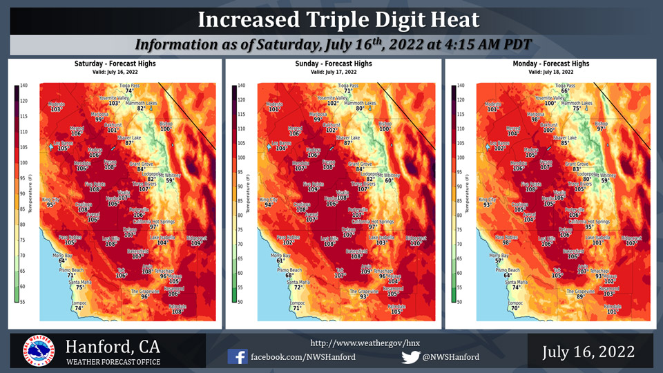
Mariposa projected high temperature for Saturday: 99 degrees, Sunday: 99 degrees, Monday: 98 degrees
Oakhurst projected high temperature for Saturday: 101 degrees, Sunday: 102 degrees, Monday: 100 degrees
Yosemite Valley projected high temperature for Saturday: 103 degrees, Sunday: 102 degrees, Monday: 100 degrees
July 16, 2022 - The National Weather Service Hanford Office reports widespread triple digit heat will continue across the lower elevations with increased temperatures this weekend into early next week.
Area Forecast Discussion
National Weather Service Hanford CA
315 AM PDT Sat Jul 16 2022
.SYNOPSIS...
Smoke from the Washburn fire will continue to spread northeast
towards Yosemite NP. Triple digit temperatures will increase
leading to an Excessive Heart Warning for today through Monday.
High temperatures will be 5 to 10 degrees above normal. A few
afternoon thunderstorms will remain possible across the higher
Sierra through the weekend and into early next week.
&&
.DISCUSSION...
High pressure centered over the Four Corners region brought more
widespread triple digit heat to the lower elevations of central
California on Friday with high temperatures around 3 to 7 degrees
above climatological averages for the middle of July. The ridge
will really flex it's muscle this weekend with high temperatures
forecast to be 5 to 10 degrees above normal. Temperatures around
104 to 109 degrees are expected across the San Joaquin Valley this
weekend as well as on Monday. The combination of these very hot
afternoon conditions combined with little overnight relief from
the heat will create a high heat risk for much of the population,
especially for those who are heat sensitive and for those without
effective cooling and/or adequate hydration. To highlight these
dangerous heat conditions, an Excessive Heat Warning is in effect
for the San Joaquin Valley, Sierra Foothills, & Kern River Valley
from Noon today through 9 PM Monday. While forecast temperatures
are as high as 112 degrees across the Indian Wells Valley this
weekend, this is only around 5 degrees above the climatological
average, so the heat risk is lower there but is still moderate.
Model ensemble means concur with the ridge gradually weakening
over the west next week as an upper trough sets up off the coast
of northern California. Temperatures will nudge down a bit each
day and highs are forecast to be back to near average by next
Friday.
Mid/upper level moisture rotating around the upper anticyclone
will continue to provide a chance of afternoon and early evening
thunderstorms over the high Sierra, mainly in Fresno and Tulare
Counties. This threat will continue today through Tuesday then
the aforementioned upper trough will bring in a drier southwest
flow aloft midweek and shunt the moisture to the east.
&&
.AVIATION...VFR conditions prevailing for the San Joaquin Valley
with localized MVFR or lower in Mariposa County due to the smoke
from the Washburn fire. There is a chance of afternoon and early
evening thunderstorms over the high Sierra in Fresno and Tulare
Counties. Elsewhere, VFR conditions will prevail through at least
the next 24 hours.
&&
.AIR QUALITY ISSUES...
On Saturday July 16 2022...Unhealthy for Sensitive Groups in
Fresno...Kern and Tulare Counties...and Sequoia National Park
and Forest.
Source: NWS

