


Click here for: Washburn Fire in Yosemite National Park Updates for Monday, July 25, 2022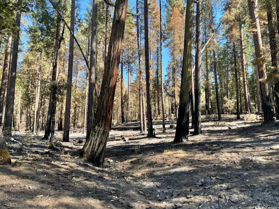
On Highway 41, a stand of timber remains standing after the fire burned through and under the trees
Credit: InciWeb
Note: If you were at or near the Mariposa Grove on July 7, 2022, please contact the NPS Investigative Services Branch (ISB) one of the following ways:
Call or text: 888-653-0009
Email: nps_isb@nps.gov
Note: Wawona Road (continuation of Highway 41 into Yosemite) between South Entrance and Yosemite Valley will tentatively reopen to visitors on Saturday, July 23, at 6 am. The Mariposa Grove of Giant Sequoias and the Wawona area will remain closed for at least another week. This closure includes all camping, lodging, vacation rentals, and other services (other than gas) in the Wawona area.
A reservation is required to drive into or through Yosemite between 6:00 a.m. and 4:00 p.m.: https://go.nps.gov/reserve.
Click here for: Washburn Fire in Yosemite National Park Updates for Monday, July 25, 2022
Evening Update CAL FIRE at 10:06 P.M.: Washburn Fire 4,866 Acres with 87% Containment, and 694 Personnel.
Basic Information
|
Current as of |
7/24/2022, 10:06:13 PM |
|
Incident Type |
Wildfire |
|
Cause |
Human Caused/under Investigation |
|
Location |
Mariposa Grove of Giant Sequoias |
|
Incident Commander |
Jim Harris, California Interagency Incident Management Team 15. |
|
Incident Description |
Full Suppression |
|
Coordinates |
37.499 latitude, -119.614 longitude |
Current Situation
|
Total Personnel |
694 |
|
Size |
4,866 Acres |
|
Percent of Perimeter Contained |
87% |
|
Fuels Involved |
Very heavy accumulations of available dead surface fuels with ample snags, downed logs, and fuel concentrations in an old growth forest landscape. Representative fuels include multi-species conifer timber with an understory of young conifer and shrubs. Very deep duff and accumulation of timber litter (branchwood and needles) dominate the forest floor. Recent large fire scars in the area include woody fuels and recent shrub growth. Live fuels (shrubs/brush) are seasonally moist and are providing limited intensity and spread. |
|
Significant Events |
Creeping, Smoldering. Minimal overnight recovery and very dry conditions, allowed crews to identify the remaining hotspots near the control lines. Crews utilized the Unmanned Aviation System carrying an infrared camera to recon the areas which are inaccessible by ground crews due to terrain. The areas flown are showing diminishing hotspots. |
Outlook
|
Planned Actions |
Continue to secure and reinforce the Hwy 41 corridor, Mariposa Grove Rd., protect remote cabins within Yosemite National Park and Sierra National Forest. Continue to construct handline where possible in the Iron Creek drainage area. |
|
Projected Incident Activity |
12 hours: Improving conditions, smoke from the Oak fire, and suppression actions the last several weeks will minimize fire activity overnight. 24 hours: Increased upper-level moisture is expected to enter the area improving what has been a persistent, dry airmass. These conditions will cause improved overnight recovery and assist in continuing overall containment of the fire. 48 hours- Heat signatures are expected to continue to diminish as the crews mop-up the remaining portions of heat near the line and the ground fuels burn out. 72-hours: Same as above. Anticipated after 72-hours: Minimal fire activity is anticipated to occur over the next 72-hour period. |
|
Remarks |
CAIIMT15 assumed command of the Washburn Fire on 07/23/22 at 7:00pm. |
Current Weather
|
Weather Concerns |
Smoke and haze from the Oak fire lingered over the Washburn fire today. This impacted the fire with slightly cooler temperatures and higher humidity along with generally light up canyon winds due to the stable smoke layer. Highs 80-90 Humidity: 14-22% Winds: Southwest 4-7 mph gusts 12 mph |
Update 6:05 P.M.Interagency BAER Team Begins Post-Fire Assessment of Washburn Fire
An interagency Burned Area Emergency Response (BAER) team has been established by the National Park Service (NPS) and Sierra National Forest (NF) to begin a joint burned area assessment of the Washburn Fire that recently burned on NPS and Forest Service federal lands. The Sierra NF BAER team leader is Todd Ellsworth, Forest Service Soil Scientist, and Chris Holbeck, a biologist with the National Park Service leads the Department of Interior NPS BAER team. Together, the interagency BAER team will produce their findings in two assessment reports for each of their respective agencies.
In addition to working and coordinating with each other’s federal agencies, the teams also coordinate with the USDA Natural Resources Conservation Service (NRCS), National Weather Service (NWS), US Geological Survey (USGFS), and other federal, state, and local agencies as they assess potential post-fire impacts to the burned watersheds.
BAER surveys are rapid assessments that evaluate the burned area to identify watersheds having increased potential for post-fire flooding, sediment flows and rockslides, and assist land managers prepare the burned area for the upcoming monsoon rains. The team focus is on potential emergency impacts to life, and safety on federal land but model hydrologic response throughout the burned area and share the team’s findings with the responsible downstream agencies.
BAER teams may consist of scientists and specialists including hydrologists, geologists, soil scientists, road engineers, botanists, biologists, archeologists, and geographic information specialists. BAER teams collect field data during their burned area surveys to analyze through GIS and computer models and present their findings along with recommended BAER emergency stabilization treatments in a BAER assessment report.
BAER teams utilize satellite imagery and specialist data to analyze and produce a runoff map that shows the levels of hydrological potential flows during rain events. This is the first step in assessing potential watershed impacts from wildfires to any federal values that may be at-risk from potential increased flooding, sedimentation, debris flows, and rockslides. BAER teams produce a report that describes potential threats associated with the burned area’s post-fire conditions sometimes including recommended emergency stabilization measures and actions. BAER emergency response efforts are focused on the protection of human life, safety, and property, as well as critical cultural and natural resource values such as the water quality of streams and wetlands on federal lands.
BAER reports are shared with interagency cooperators who work with downstream private home and landowners to prepare for potential post-fire flooding and debris flow impacts. Homes or businesses that could be impacted by flooding from federal land that resulted from wildfires may be eligible for flood insurance coverage from the National Flood Insurance Program (NFIP). Information about NFIP is available through FEMA at www.fema.gov/national-flood-insurance-program, or www.floodsmart.gov/wildfires. Other flood preparedness information is available at www.ready.gov/floods at www.floodsmart.gov/.
BAER SAFETY MESSAGE: Everyone near and downstream from the burned areas should remain alert and stay updated on weather conditions that may result in heavy rains and increased water runoff. Flash flooding may occur quickly during heavy rain events – be prepared to act. Current weather and emergency notifications can be found at the National Weather Service websites: www.weather.gov/sto/ and www.weather.gov/hnx/.
Update 11:45 A.M. - Daily Update
Washburn Fire
Incident Update July 24, 2022
Location: Yosemite National Park, Mariposa Grove
Percent Contained: 79%
Start Date: July 7, 2022
Cause: Human Caused/Under Investigation
Size: 4,857 acres
Number of Personnel Assigned: 775
Resources Assigned: 31 Hand Crews, 8 Helicopters, 43 Engines, 2 Dozers, 17 Water Tenders, 1 Masticator
Washburn Fire Update- One of the main indicators of seasonal fire danger is an index called the Energy Release Component. The extended drought conditions and very dry airmass over the area yesterday resulted in the highest Energy Release Component rating ever recorded for the Central Sierra Predicted Service Area. These conditions were the cause for rapid rates of spread when the Oak Fire ignited on Friday. The Oak Fire is burning approximately 12-miles west of the Washburn fire. Coordination is occurring between fire managers and both air and ground resources responded from the Washburn Fire to assist in the suppression efforts occurring on the Oak Fire.
Today, resources on the Washburn Fire will continue to actively secure the remaining portions of heat near control lines. The two main areas of focus are near the confluence of the South Fork Merced River and Iron Creek. Crews are coordinating with pilots using Unmanned Aircraft Systems (UAS) containing an infrared camera to provide accurate information on the hotspots burning in the remote and rugged terrain. The predicted southwest winds will transport most of the smoke generated from the Oak Fire plume to the north, but smoke and haze will linger over the Washburn Fire today. Conditions will remain warm and dry with temperatures in the mid 80’s and minimum humidity around 15%.
Information for the Oak Fire can be found at https://www.fire.ca.gov/incidents/2022/7/22/oak-fire/ or by calling 844-MMU-FIRE (844-668-3473). The Oak Fire started on Friday, July 22nd at Highway 140 and Carstens Road, near Midpines, CA (outside of Yosemite National Park boundaries). The Oak Fire currently sits at 14,281 acres and is 0% contained. Highway 140 and surrounding roads have closures in effect.
Wawona Road (Highway 41) has reopened as of 6:00 am on Saturday, July 23.
New Forest Order No. 05-15-51-22-27- Sierra National Forest updated the Washburn Fire Closure Forest Order, effective July 23, 2022, through August 1, 2022. This order supersedes the previous Forest Order. The following roads remain closed: Mt. Raymond Road, Big Sandy Road, White Chief Mtn. Road, Sky Ranch Road (Between its intersections with FS Road 5S40Z and 6S07), Lost Lake Road, Chiquito Lake Road, and Red Top Road. For more information, visit: https://www.fs.usda.gov/alerts/sierra/alerts-notices/?aid=74510 For information regarding Wawona Repopulation or Yosemite National Park Fire restrictions, please visit: inciweb.nwcg.gov/incident/8209/
Tip Line: If you were at or near the Mariposa Grove on July 7, 2022, please contact the NPS Investigative Services Branch (ISB)
Call/Text – (888)-653-0009 Email- nps_isb@nps.gov Online: Submit a Tip
Update 6:10 A.M. Air Quality Measurements
Update 6:00 A.M. Washburn Fire in Yosemite National Park Briefing and Infrared Maps for Sunday, July 24, 2022
July 24, 2022 - Washburn Fire in Yosemite National Park is at 4,857 Acres and 79% Containment.
Basic Information
| Current as of | 7/24/2022, 10:19:19 AM |
| Incident Type | Wildfire |
| Cause | Human Caused/under Investigation |
| Location | Southern portion of Yosemite National Park; Sierra National Forest. |
| Incident Commander | Jim Harris, California Interagency Incident Management Team 15. |
| Incident Description | Full Suppression |
| Coordinates | 37.499 latitude, -119.614 longitude |
Current Situation
| Total Personnel | 775 |
| Size | 4,857 Acres |
| Percent of Perimeter Contained | 79% |
| Fuels Involved |
Very heavy accumulations of available dead surface fuels with ample snags, downed logs, and fuel concentrations in an old growth forest landscape. Representative fuels include multi-species conifer timber with an understory of young conifer and shrubs. Very deep duff and accumulation of timber litter (branchwood and needles) dominate the forest floor. Recent large fire scars in the area include woody fuels and recent shrub growth. Live fuels (shrubs/brush) are seasonally moist and are providing limited intensity and spread. |
| Significant Events |
Creeping, Smoldering. Smoke from the Oak fire helped moderate conditions over the Washburn fire. Each day heat found near the control lines diminishes, which is aligned with the intel provided by the National Infrared Operations flights. The extremely dry dead ground fuel continues to consume within the perimeter of the fire with minimal threat to the control lines. Fire behavior can best be described as creeping and smoldering. |
Outlook
| Planned Actions |
Continue to secure and reinforce the Hwy 41 corridor, Mariposa Grove Rd., Protect remote cabins within Yosemite National Park and Sierra National Forest. Continue to construct handline where possible in the Iron Creek drainage area. |
| Projected Incident Activity |
12 hours: Improving conditions, smoke from the Oak fire, and suppression actions the last several weeks will minimize fire activity overnight. 24 hours: The combined effort of air and ground resources have reduced fire activity along the perimeter. There is still several relatively large areas holding heat near the line near the South Fork Merced River on the southern flank and near Star Dip on the northern flank. The dry fuels will continue to consume in these areas with limited threat to control lines. 48 hours- Heat signatures are expected to continue to diminish as the crews mop-up the remaining portions of heat near the line and the ground fuels burn out. 72 hours: Same as above. Anticipated after 72 hours: Minimal fire activity is anticipated to occur over the next 72 hour period. |
| Remarks |
CAIIMT15 assumed command of the Washburn Fire on 07/23/22 at 7:00pm. |
Current Weather
| Weather Concerns |
Smoke and haze from the Oak fire lingered over the Washburn fire today. This impacted the fire with slightly cooler temperatures and higher humidity along with generally light up canyon winds due to the stable smoke layer. Highs 80-90 Humidity: 14-22% Winds: Southwest 4-7 mph gusts 12 mph |
Click here for: Washburn Fire in Yosemite National Park Updates for Saturday, July 23, 2022

