


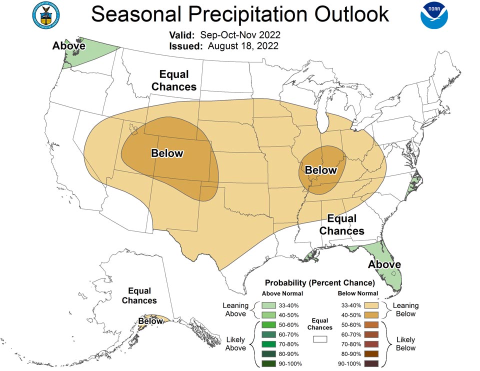
August 20, 2022 - PRECIPITATION - During SON 2022, above-normal precipitation is favored for small portions of the Pacific Northwest, Gulf Coast, and southeast Coast, supported by the NMME and statistical consolidation.
The consolidation also supports a broad area of below-normal across much of the CONUS with the highest probabilities across the Central and Southern Rockies, reflective of the end of the monsoon and influenced by La Niña later in the season.
Outlooks from OND2022 through JFM2023 are largely similar to the July outlooks but with minor changes. One minor change is the addition of an area where above-normal precipitation is favored across the Pacific Northwest and Northern Rockies.
Another minor change is the slight increase in probabilities for below-normal precipitation across the Southwest and Southern California, reflecting the greater certainty in La Niña persisting through the winter.
The La Niña signature is likely to fade during FMA and MAM2023, given that La Niña and ENSO-neutral are about even odds.
Outlooks for AMJ through June-July-August (JJA) reflect the consolidation, which now includes a small area of below-normal precipitation across the Northern Rockies, largely coming from trends .
Across the eastern CONUS, the AMJ through August-September-October (ASO) outlooks are unchanged.
For Alaska, below-normal precipitation is favored across southern Mainland Alaska and the Alaska Panhandle during OND2022 and DJF2022-2023 with above-normal precipitation across the North Slope and near the border with Canada. During DJF, odds for above-normal precipitation peak along the west coast of Alaska, and thereafter diminish through MAM2023. From AMJ through JJA, below normal precipitation is favored for southwest mainland Alaska and the Alaska Panhandle, largely reflective of trends.
TEMPERATURE
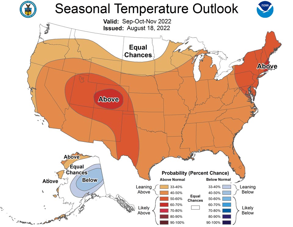
Above-normal temperatures are favored throughout much of the CONUS during SON 2022, with probabilities that vary regionally.
The areas with highest probabilities for above-normal temperatures are across the Central Rockies and New England, where dynamical model outputs and statistical tools reflect similar signals .
The current SON outlook has lower probabilities for above-normal temperatures across the Pacific Northwest and Northern California to reflect the latest model guidance from the NMME.
Chances of above-normal temperatures are increased from the previous SON and October-November-December (OND) outlooks across portions of the Northern Plains. The outlook for OND2022 reflects similar changes over the Pacific Northwest and Northern California, as well as the Northern Plains.
Across Alaska, recent guidance, as consolidated in the NMME/statistical tools consolidation, indicates mixed signals across the western portions of the state with some indications of below-normal temperatures across the interior portions of the state, which are included in the current outlook for SON.
The outlook for December-January-February (DJF) 2022-2023 now slightly favors below-normal temperatures from the Pacific Northwest to the Northern Plains, reflecting current guidance and a bit more certainty in the La Niña continuing through early portions of 2023.
Correspondingly, the outlooks for JFM and FMA 2023 are also colder across the Northern Great Plains.
Outlooks for March-April-May (MAM) through SON 2023 are based on the consolidation of the statistical tools and ENSO/decadal trend tool, and are largely unchanged from the previous release.
Summary Of The Outlook For Non-Technical Users.
The September-October-November (SON) 2022 temperature outlook predicts elevated
probabilities of above-normal seasonal mean temperatures across most of the
Contiguous United States (CONUS). The largest probabilities of above-normal
temperatures exceed 60 percent for parts of New England and portions of the
Central Rockies. The SON precipitation outlook predicts elevated probabilities
of above-normal precipitation for portions of the Gulf Coast, Florida, and the
Mid-Atlantic Coast, as well as a small portion of the Pacific Northwest.
Below-normal precipitation is more likely from the Great Basin to the Western
Great Lakes, southward to the Southern Appalachians, and southwest to the Rio
Grande Valley. The area of below-normal precipitation encompasses and includes
much of the Great Plains. Below-normal precipitation is also favored for
portions of southern Mainland Alaska. Equal chances (EC) of above, near, and
below normal temperature or precipitation are forecast in areas where the
likelihood of seasonal mean temperatures or seasonal accumulated precipitation
amounts are expected to be similar to climatological probabilities.

A La Niña advisory remains in effect and equatorial sea surface temperatures
(SSTs) are below average across the central and eastern Pacific Ocean. The
tropical Pacific atmosphere is consistent with a La Niña, with enhanced
low-level easterly winds  and suppressed convection near the Date Line. La Niña
is expected to continue, with chances for La Niña gradually decreasing from 86%
in the coming season to 60% during December-February 2022-23.


BASIS AND SUMMARY OF THE CURRENT LONG-LEAD OUTLOOKS
Note: For Graphical Displays of the Forecast Tools Discussed Below See:
http://www.cpc.ncep.noaa.gov/products/predictions/90day/tools/briefing

CURRENT ATMOSPHERIC AND OCEANIC CONDITIONS

ceanic and atmospheric observations across the equatorial Pacific are
consistent with the persistence of La Niña conditions. The observed weekly SSTs
show negative anomalies across most of the central and eastern equatorial
Pacific, with the largest negative anomalies of greater than -1 degree C
generally near the Date Line and over the far eastern Pacific near the coast of
South America. SSTs from 150W to 110W have cooled about 1 degree C since mid
July, as the influence of a downwelling Kelvin wave subsided. Correspondingly,
subsurface temperature anomalies returned to negative values from about 160W to
110W to a depth of about 200 meters. There are currently almost no areas of
above normal ocean temperatures in the eastern Pacific along the equator, a
shift from early July. Low-level easterly and upper-level westerly wind
anomalies persisted from July into August, with very strong trade winds across
much of the Pacific. Suppressed convection continues near and to the west of
the Date Line, primarily south of the equator, with enhanced convection over
parts of the Maritime Continent. Positive (negative) SST anomalies remain near
the south (west) coast of Alaska and along most of the east coast of the CONUS,
potentially influencing local climate conditions.


PROGNOSTIC DISCUSSION OF SST FORECASTS

The CPC SST Consolidation for the Niño 3.4 region indicates a slight decrease
in the magnitude of the negative anomalies this summer, followed by
increasingly negative anomalies peaking around -1.1 degrees C during the
autumn, with a return to ENSO-neutral by spring of 2023. The spread among
ensemble members of the North America Multi-Model Ensemble (NMME) for the Nino
3.4 forecast for autumn ranges from a strong La Niña with anomalies around -1.7
C to near zero. Niño 3.4 forecasts by statistical tools range from anomalies
exceeding -1.3 C for the Constructed Analog (CA) to about -0.2 C for the
Canonical Correlation Analysis (CCA). The NMME maintains a La Niña with
negative anomalies averaged for the Niño 3.4 region at or below -0.5 degrees C
persisting through JFM 2023. As of early August, the CPC ENSO forecast has
probabilities in excess of 70 percent for the continuation of La Niña through
the NDJ 2022-2023. The official outlook has even odds for La Niña or
ENSO-neutral by JFM 2023.

PROGNOSTIC TOOLS USED FOR U.S. TEMPERATURE AND PRECIPITATION OUTLOOKS

Dynamical model guidance from NMME and the Calibration, Bridging, and Merging
(CBaM) version of the NMME were used through lead 5. La Niña temperature and
precipitation impacts based on regressions on Niño-3.4 SST anomalies were also
included for seasons from NDJ 2022 through February-March-April (FMA) 2023. An
ENSO-OCN tool that uses the consolidation forecasts of the Niño-3.4 SST
anomalies plus decadal trends  to predict temperature and precipitation was also
considered for all leads. The consolidation tool, which combines both the NMME
and various statistical tools as inputs, was used through all seasonal leads.
At longer leads, from April-May-June (AMJ) to SON 2023, decadal trends
represented by the optimum climate normals (OCN) were the primary driver of the
climate outlooks.

FORECASTER: Matthew Rosencrans

The Climatic normals are based on conditions between 1991 and 2020, following
the World Meterological Organization convention of using the most recent 3
complete decades as the climatic reference period.  The probability anomalies
for temperature and precipitation based on these new normals better represent
shorter term climatic anomalies than the forecasts based on older normals.

For a description of of the standard forecast tools - their skill- and the
forecast format please see our web page at
http://www.cpc.ncep.noaa.gov/products/predictions/long_range/tools.html
(Use Lower Cas e Letters)
Information on the formation of skill of the CAS forecasts may be found at:
http://www.cpc.ncep.noaa.gov/products/Soilmst_Monitoring/US/Outlook/outlook.shtm
l
(use lowercase letters)
Notes - These climate outlooks are intended for use prior to the start of their
valid period.  Within any given valid period observations and short and medium
range forecasts should be consulted.

This set of outlooks will be superseded by the issuance of the new set next
month on Sep 15 2022
Source: NOAA

