


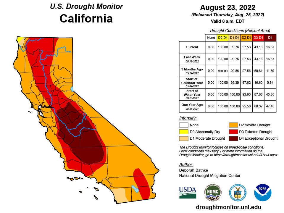
California and National Drought Summary for August 23, 2022
Summary
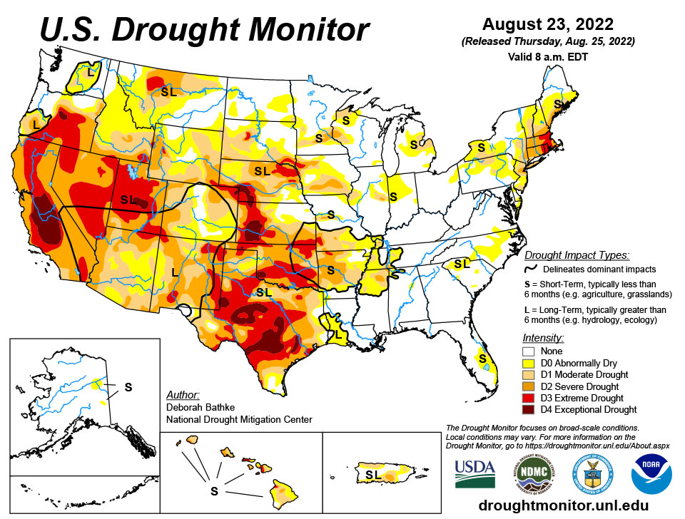
August 25, 2022 - Record-breaking rainfall led to aggressive improvements in drought conditions across parts of the South. The heavy rainfall and flooding led to communications outages at the National Weather Service office leaving climatologists without access to important data and tools needed to fully analyze the effect of this event. The magnitude of this event meant prioritizing improvements on this week’s map in these areas and in the Southwest, where the Monsoon season remains active. Drought expanded in the Northwest was warm, dry conditions continued across the region. The Midwest, Southeast, and Northeast saw a mix of improvements and degradations.
Northeast
Drought persisted or expanded across much of the Northeast. Vermont saw increases to moderate drought (D1) areas where rainfall deficits of near 6 inches over the last 90 days dried out soils and lowered streamflows. Likewise, drought expanded in Connecticut (moderate drought, D2) and New Jersey (moderate and extreme drought, D1 and D2) where deficits are equally impressive. Recent rains improved abnormally dry conditions (D0) in northern Maine, northern New Hampshire, and Delaware.
Southeast
Spotty, heavy rain fell across the Southeast this week leading to improvements to areas of moderate drought (D1) and abnormal dryness (D0) in the Carolinas. Rainfall of 150 to 300 percent of normal for the week erased short term moisture deficits, replenished soils, and restored streamflows. Abnormally dryness (D0) and moderate drought (D1) expanded in the Florida Peninsula where rainfall deficits continue to build. The state drought team notes below normal levels in Lake Kissimee and inflows into Lake Okeechobee in addition to dry soils and stressed vegetation.
South
This week’s storm event led to broad 1 and 2-category improvements across large parts of the South. All states in the region show improvements. Rainfall close to the data cut off time (Tuesday at 8:00 a.m. EDT), data communications issues caused by the flooding, and lags in the hydrologic system in response to rainfall events means that the full impact of this storm on drought conditions is not yet apparent. Analysis will continue next week as more data become available. A few impressive statistics include the following. According to National Weather Service records, prior to this week’s event, the Dallas-Fort Worth Area went 67 days without measurable precipitation, the second longest streak on record going back to 1898. The August 21-22, 24-hour total of 9.19 inches tied for the second highest 24-hour total. The Texas State Climatologist noted that the largest flood control rain gauge total was 15.16 inches!
Midwest
Spotty, heavy rain fell across the Midwest this week leading to a mix of drought improvement and deterioration. Moderate drought (D1) improved in western Kentucky in response to above normal rainfall over the past 30 days. Meanwhile, nearby counties that missed these recent heavy rains saw an expansion of D1. In Missouri, rainfall of 150 to 300 percent of normal for the week led to broad 1-category improvements to areas of moderate (D1), severe (D2), and extreme (D3) drought. Totals of 1 to 4 inches erased short term moisture deficits, replenished soils, and restored streamflows. Central Minnesota also saw improvements to D1 in response to recent rainfall and seasonable temperature. Illinois saw conditions improve in the east and central part of the state and expand in the west. Moderate drought increased near the Iowa border where deficits of over 5 inches over the last 90 days dried out soils and lowered streamflows. Additional analysis across the Midwest next week is likely to result in increasing drought severity across Iowa due to persistent dry weather.
High Plains
Warm, dry conditions continued across the region. Moderate drought (D1) expanded in western South Dakota and northeast Wyoming where rainfall deficits of near 3 inches over the last 90 days dried out soils, lowered streamflow, and stressed vegetation. Additional analysis across the High Plains next week is likely to result in increasing drought severity across parts of the region due to persistent dry weather.
West
An active monsoon season in the Southwest led to improvements to drought conditions. Precipitation has improved many drought indicators including soil moisture, streamflow, and well data. Moderate drought (D2) improved in northern and southern Arizona. Moderate (D2) and extreme (D3) drought improved in southern and eastern New Mexico. Extreme drought (D3) improved in Utah and Nevada. Additional improvements are expected next week as the effect of the recent rainfall continues to be analyzed. To the north, Idaho and Montana saw an expansion to abnormally dry areas. Persistent warm, dry weather is likely to lead to additional degradations as soils continue to dry and vegetation suffers.
Caribbean
In Puerto Rico, above normal rainfall across much of Puerto Rico led to 1-category improvements on the northwest, northeast, and southwest parts of the Island.
Some beneficial rain fell across parts of the USVI islands this drought week. Cyril E King Airport at St. Thomas had a total of 4.90 inches of rain for the week, with most of that rain (4.24 inches) falling in just one day (Aug 17). This gave the month-to-date total of 5.51 inches or close to twice its monthly normal. Year-to-date rainfall total at the airport was 93.4% of normal. Rainfall totals varied across the CoCoRaHs stations. VI-ST-1 had a little over 3 inches of rain, while the rest had between 0.13 to 0.80 inch of rain. Groundwater levels seemed to have been improving, but not by much. SPI values at 1, 3, 6, and 9 months were indicative of drought free conditions, while at the 12 months were indicative of moderate drought. According to the Vegetation Health Index (VHI), vegetation in the island was stressed. St. Thomas drought classification for the week was changed from short- and long-term severe drought (D2-SL) to long-term severe drought (D2-L).
In St. Croix, the Henry Rohlsen airport had 1.49 inches of rain for the week, resulting in a month-to-date of 92.7% of normal. The airport's year-to-date was 89.7% of normal. Weekly rainfall totals across the CoCoRaHs stations were between 0.34 inch to 3.23 inches. Groundwater levels continued to be low. SPI values at the 1 and 3 months were indicative of no drought, while the 6, 9, and 12 months were indicative of abnormally dry to severe drought. Vegetation seemed to be improving somewhat across the region, according to the VHI. Similar to St. Thomas, this week's drought classification for St. Croix changed from short- and long-term severe drought (D2-SL) to long-term severe drought (D2-L).
Short- and long-term extreme drought (D3-SL) persisted across St. John. The Windswept Beach station had only 0.79 inch of rain for the week, 1.12 inch (or 33.3% of normal) for the month-to-date, and 66.7% of normal rainfall for the year-to-date. Other two CoCoRaHs stations across St. John had a bit more rain at 1.36 and 1.99 inches of rain. The groundwater levels have been steadily decreasing with not much improvement. SPI values at all timescales were indicative of severe to extreme drought.
Pacific
In Alaska, abnormal dryness improved in the Northeast Interior based on input from the state monitoring team and reports of rainfall the past week.
In Hawaii, no changes were made to the map this week, but conditions look ripe for degradation next week if the dryness persists.
Palau had 1.62 inches of rain this week, which is a little less than the weekly 2-inches threshold to meet most water needs. However, drought free conditions persisted since the two previous weeks were very wet with weekly rainfall totals over 5 inches.
The Marianas had over 2 inches of rain across the region, securing another week of drought free conditions.
Rainfall varied across the Federated States of Micronesia this week. Yap, Chuuk, Pohnpei, Kosrae, Ulithi, and Woleai had over 2 inches of rain. Ulithi's drought classification was changed from abnormally dry to drought free conditions since it has had two consecutive wet weeks and drought impacts haven't been reported. Drought was not a concern for the other locations. Nukuoro and Pingelap had over 1 inch of rain. Drought free conditions persisted for these locations since month-to-date totals are above the 8-monthly threshold to meet most water needs. Lukunor and Kapingamarangi had less than 1 inch of rain for the week. Kapingamarangi's drought classification continued to be moderate drought since its month-to-date total was only 2.65 inches.
Similarly, most locations across the Marshall Islands had less than 2 inches of rain this week; however, drought free conditions persisted across all islands since most had month-to-date rainfall totals that were above the 8-inches threshold. Kwajalein and Ailinglaplap were the only locations to surpass its weekly threshold with 4.03 and 3.48 inches of rain, respectively.
Tutuila also continued to be drought free. Pago Pago had 1.65 inches for the week, while Siufaga Ridge had only 0.15 inch of rain. However, month-to-date for both locations were above their 4-inches threshold to meet most water needs.
Looking Ahead
The National Weather Service Weather Prediction Center (valid August 25 – August 28) calls for rainfall over parts of the South, the Southwest, the Northern Rockies, Upper Midwest, and Northeast. Meanwhile, dry weather is expected to continue across the drought-stricken areas of the Pacific Northwest, California, the Central Great Basin, and Central Plains. Moving into next week (valid August 30 – September 1), the forecast calls for more rain across Texas, Oklahoma, and much of the eastern half of the CONUS. At 8 – 14 days, the Climate Prediction Center Outlook (valid September 1 – September 7) calls for above normal temperatures across the West, High Plains, Upper Midwest, East Coast, and interior Alaska. Below normal temperatures are predicted across southeast New Mexico, Texas, and Southern Oklahoma. Below normal precipitation is favored across much of the northern tier of CONUS. Above normal precipitation is favored for the southern tier, from New Mexico eastward.
Author(s):
Deborah Bathke, National Drought Mitigation Center
Ahira Sanchez-Lugo, NOAA/NCEI
Dryness Categories
D0 Abnormally Dry—used for areas showing dryness but not yet in drought, or for areas recovering from drought.
Drought Intensity Categories
D1 Moderate Drought
D2 Severe Drought
D3 Extreme Drought
D4 Exceptional Drought
Drought or Dryness Types
S Short-term, typically less than 6 months (agriculture, grasslands)
L Long-term, typically more than 6 months (hydrology, ecology)
SL Area contains both short- and long-term impacts
Source: National Drought Mitigation Center

