


California and National Drought Summary for August 30, 2022
Summary
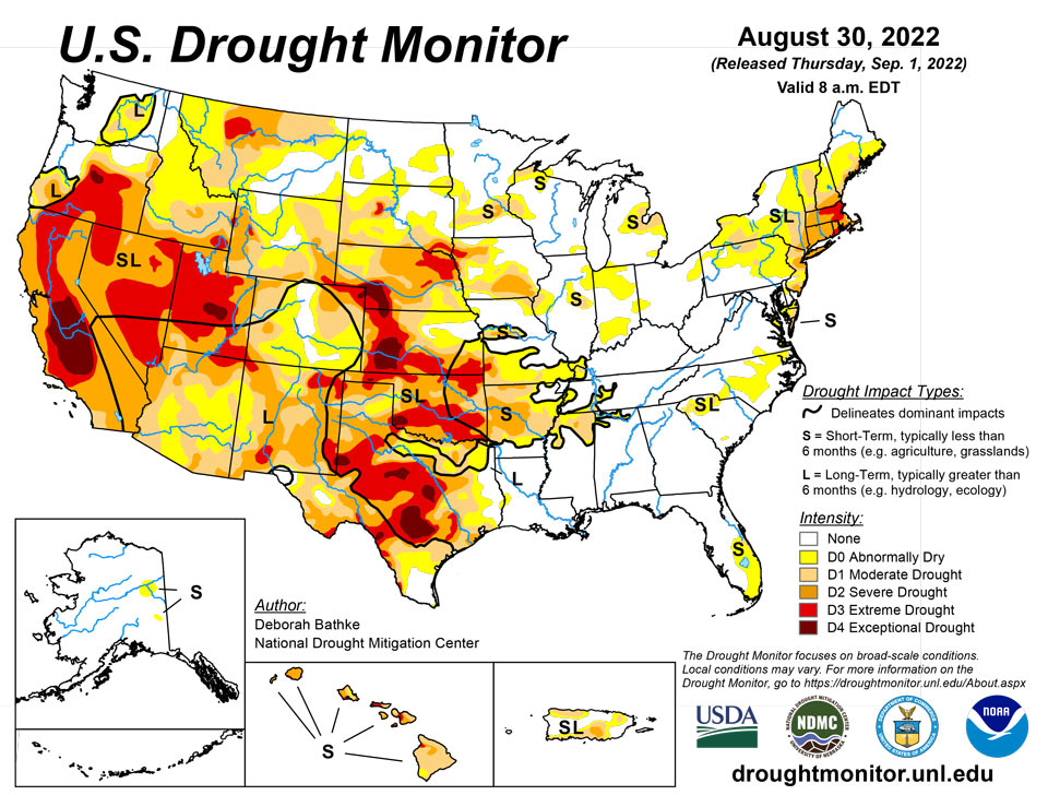
September 1, 2022 - Broad drought improvements continued across parts of the South for the second week in a row as the ongoing effects of record-setting rainfall over the last two weeks became apparent. The North American Monsoon also continued to provide much-needed rainfall in the Southwest, leading to additional improvements across much of the region. Drought expanded in the Northwest as warm, dry conditions continued across the region, while the Midwest, Southeast, and Northeast saw a mix of improvements and degradations due to locally heavy rain.
Northeast
Drought persisted or expanded across much of the Northeast. Vermont, New York, New Jersey, Delaware, Maryland and Virginia saw increases in moderate (D1) drought areas where continued rainfall deficits, combined with warm weather, dried out soils and reduced streamflow. Severe (D2) drought expanded in Connecticut, Massachusetts and New Jersey where 30-day rainfall totals are 3 to 4 inches below normal, and 90-day totals are 6 to 9 inches below normal. Recent rains improved D1 and D2 conditions along the Maine coast and extreme (D3) drought across the central parts of Connecticut and Massachusetts.
Southeast
Last week’s rainfall missed most of the drought-impacted areas in the Southeast. Moderate (D1) drought expanded in South Carolina where 90-day rainfall totals were 4 to 6 inches below normal, leading to lower streamflow and stressed vegetation. Drought persists in northwest Alabama where rainfall deficits of more than 6 inches have continued over the last 90 days.
South
Rainfall totals over the past two weeks once again led to broad 1- and 2-category improvements across large parts of the South. For the second week in a row, all states in the region showed improvements as the effect of the rainfall became apparent in drought indicators such as soil moisture, streamflow and vegetation. Rainfall records show that the previous two weeks ranked in the top 10 wettest for this time of year in many locations in the region. Some of these records go back over 100 years. Drought remains in areas that missed out on the recent heavy rains and those in which rainfall deficits still exist at 90-plus days so that deeper soil moisture, shallow groundwater and streamflow indicators have yet to recover. Extreme (D3) drought expanded in northern Oklahoma in the areas that missed out on the heavy rain. Rainfall deficits of nearly 6 inches have continued to dry out soils and stress vegetation.
Midwest
Spotty, heavy rain fell across the Midwest this week, leading to a mix of drought improvement and deterioration. Above-normal rainfall led to 1-category improvements across parts of eastern Minnesota, Wisconsin, Michigan, central Iowa, Illinois and Indiana. The much-needed rainfall helped replenish soil moisture and streamflow. Moderate (D1) and severe (D2) drought expanded in northwest and southeast Iowa where rainfall deficits of 6 to 8 inches over the last 90 days have dried out soils, reduced streamflow and strained vegetation.
High Plains
Warm, dry conditions continued across much of the region with the Dakotas, Nebraska and Kansas seeing some areas of worsening conditions. In Nebraska and Kansas, all levels of drought expanded as short-term precipitation deficits, on top of long-term dryness, continued to deplete soil moisture and stress vegetation. Exceptional (D4) drought expanded in the southwest where rainfall deficits of over 3.5 inches have occurred over the last 90 days. Extreme (D3), severe (D2) and moderate (D1) drought expanded in the eastern half of Nebraska where rainfall deficits of 3 to nearly 7 inches have occurred over the last 90 days. Other areas of Nebraska seeing degradations include north-central Nebraska, where D2 expanded, and the Panhandle, where D1 expanded. Similarly, Kansas also saw large areas of deterioration. In the western half of the state, D1, D2, D3 and D4 expanded where rainfall deficits near 5 inches occurred over the last 90 days. In the east, improvements were made to D1 where the heaviest rain fell over the last 2 weeks. Improvements were also made in eastern South Dakota to D1 along a band of heavy rain last week.
West
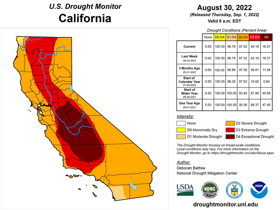
The North American Monsoon continued to provide excellent rainfall in the Southwest. Many areas in the region only receive about five inches of rain annually, but a few spots have nearly equaled this annual average in the last two weeks alone. Drought conditions improved in areas receiving the heaviest rain. Many drought indicators, including soil moisture, streamflow and well data, are responding to the rainfall. Improvements were made to moderate (D1) and severe (D2) drought in Arizona, extreme (D3) drought in Southern California and eastern Utah, and D2 and D3 conditions in eastern New Mexico. To the north, Montana saw an expansion to abnormally dry (D0) and D1 areas as conditions began to rapidly deteriorate. Low rainfall, combined with high evaporative demand, has lowered streamflow and stressed vegetation there.
Caribbean
In Puerto Rico, no changes were made to the map this week.
Rainfall totals across St. Thomas (airport and CoCoRaHs stations) ranged between 0.27 inch to 1.10 inches. The airport had a month-to-date total of 5.84 inches, which is 144.6% of normal. Year-to-date was at 90.0% of normal. SPI values at the 1, 3, and 9 months were indicative of no drought, while the 6 and 12 months were indicative of abnormally dry conditions to moderate drought. Groundwater levels at the Grade School 3 Well had improved at the beginning of the month, but were steadily decreasing once again. For this reason, long-term severe drought persisted in St. Thomas.
Similarly, long-term severe drought persisted across St. Croix. Rainfall totals ranged between 0.05 to 1.0 inch. Month-to-date totals at the airport was 2.15 inches or 71.9% of normal, while the year-to-date was 86.4% of normal. SPI values at the 1, 6, 9, and 12 months were indicative of abnormally dry conditions to severe drought. SPI value at the 3-month was indicative of drought free conditions. Groundwater levels at the Adventure 28 Well were slightly improving.
St. John had some beneficial rains, with totals between 0.87 inch to 1.76 inches. Month-to-date rainfall total at the Windswept Beach was 64.9% of normal and 70.9% of normal for the year-to-date. SPI at the 3, 6, 9, and 12 months were indicative of moderate to severe drought, while it was abnormally dry at the 1 month period. The groundwater levels at the Susannaberg DPW 3 well was steadily decreasing. Short- to long-term extreme drought persisted for St. John.
Pacific
In Alaska, no changes were made to the map this week.
In Hawaii, dry conditions continued. Niihau, Kauai, Molokai, Lanai, Maui and the Big Island all saw drought conditions worsen as rainfall deficits increased, leading to reductions in streamflow and stressed vegetation. Localized heavy rainfall on Maui led to improvements to extreme (D3) drought on the southwest part of the island.
Palau had 1.17 inch of rain this week. Even though it was less than its weekly threshold of 2 inches to meet most water needs, drought was not a concern at this time since its month-to-date rainfall total was close to double its monthly threshold of 8 inches.
Most locations across the Marianas had a wet week, securing another week of drought free conditions. This week's rainfall totals surpassed their weekly threshold of 1 inch, resulting in month-to-date totals that were close to double their monthly threshold of 4 inches.
Several locations across the Federated States of Micronesia (FSM) had a dry week, with rainfall totals less than their weekly threshold of 2 inches to meet most water needs. Despite this, drought was not a concern for most locations across the FSM since most locations had month-to-date totals surpassing their monthly threshold of 8 inches. Kapingamarangi received some much needed rain (1.52 inches) this week, but its month-to-date total was only 4.35 inches. Short- to long-term moderate drought continued for Kapingamarangi. Pohnpei and Nukuoro were the only locations to receive over 2 inches of rain this week.
This was a wet week for most locations across the Marshall Islands. Mili had the most rain with a total of 4.60 inches for the week. Jaluit was the only location to have less than 1 inch of rain; however, its month-to-date total was close to the threshold of 8 inches to meet most water needs. Drought free conditions persisted across the Marshall Islands this week.
Across American Samoa, Pago Pago and Toa Ridge had 0.85 and 0.88 inch of rain, respectively, while Siufaga Ridge had 1.32 inches for the week. Drought was not a concern at this time for American Samoa.
Looking Ahead
The National Weather Service Weather Prediction Center forecast (valid September 1 – September 4) calls for rainfall over parts of the South, the Southeast, the Central Plains and the Upper Midwest. Meanwhile, dry weather is expected to continue across much of the West, the Northern Plains and the Mid-Atlantic. Moving into next week (valid September 5 – September 8), the forecast calls for continued rain across much of the South and Southeast, while the West, High Plains and parts of the Midwest are expected to remain dry. Heavy rain is expected across portions of the Alaska Panhandle and mainland Alaska. At 8 – 14 days, the Climate Prediction Center Outlook (valid September 8 – September 14) calls for above-normal temperatures across most of the continental U.S. Below-normal to normal temperatures are predicted across southern Arizona, southern New Mexico and West Texas. Below-normal precipitation is favored across much of the northern tier of the continental U.S., while normal to above-normal precipitation is favored for the rest of the continental U.S. Below-normal precipitation is expected across parts of the Pacific Northwest, the Intermountain West, and parts of the Midwest and Northeast.
Author(s):
Deborah Bathke, National Drought Mitigation Center
Ahira Sanchez-Lugo, NOAA/NCEI
Dryness Categories
D0 Abnormally Dry—used for areas showing dryness but not yet in drought, or for areas recovering from drought.
Drought Intensity Categories
D1 Moderate Drought
D2 Severe Drought
D3 Extreme Drought
D4 Exceptional Drought
Drought or Dryness Types
S Short-term, typically less than 6 months (agriculture, grasslands)
L Long-term, typically more than 6 months (hydrology, ecology)
SL Area contains both short- and long-term impacts
Source: National Drought Mitigation Center

