


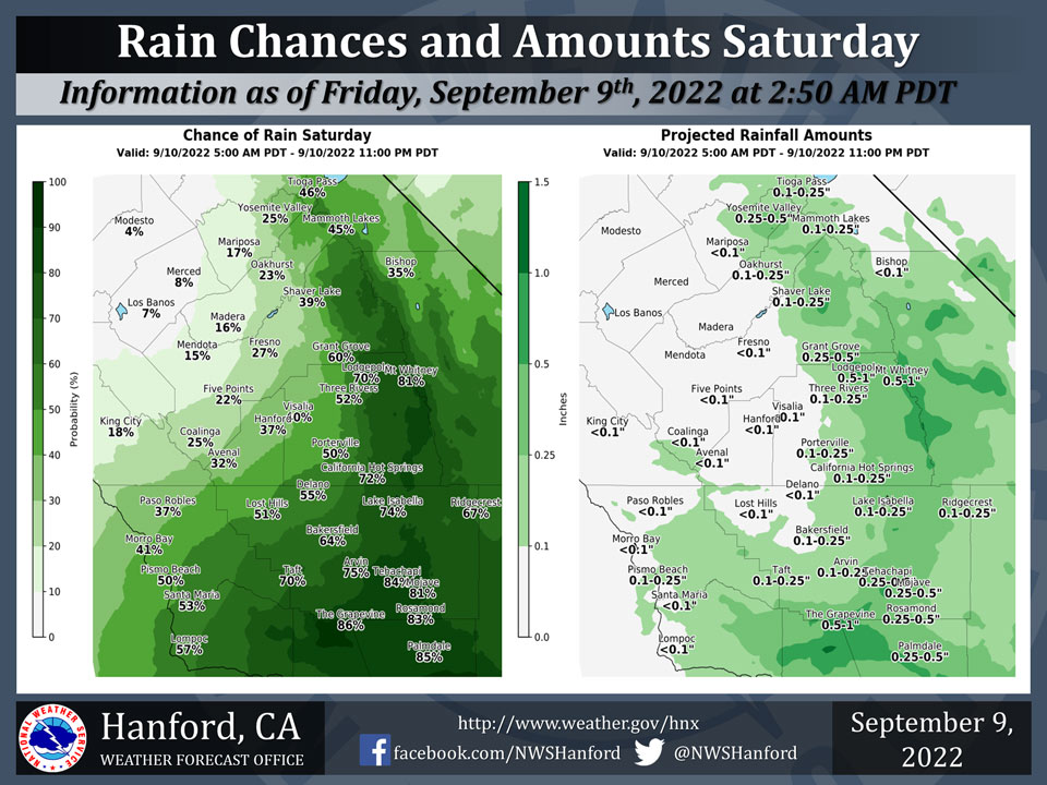
Mariposa has a 17% Chance of Rain on Saturday
Oakhurst has a 23% Chance of Rain on Saturday
Yosemite Valley has a 25% Chance of Rain on Saturday
September 9, 2022 - The National Weather Service Hanford Office reports a significant amount of atmospheric moisture will surge northward into Central California Saturday, resulting in elevated rain chances.The majority of this rain will fall Saturday afternoon.
The heaviest rainfall is expected in the Kern County mountains and desert and in the Southern Sierra Nevada.
A Flash Flood Watch is in effect for the Kern County mountains and desert and Southern Sierra Nevada from 5 AM PDT until 11 PM PDT Saturday.
Area Forecast Discussion
National Weather Service Hanford CA
400 AM PDT Fri Sep 9 2022
.SYNOPSIS...An Excessive Heat Warning continues today with more
dangerous record-breaking heat expected. Temperatures will cool
to near average this weekend. There is a slight chance for some
thunderstorms over the mountains and desert this afternoon and
evening. Moisture from weakening Tropical Storm Kay will bring
more widespread chances of showers and thunderstorms on Saturday
with a Flood Watch in effect for the Kern County mountains and
desert northward through Sequoia NP. Showers and thunderstorms
will remain possible on Sunday, mainly across the mountains.
&&
.DISCUSSION...
Strong high pressure centered over the Great Basin brought more
record-breaking heat on Thursday with high temperatures around
12 to 15 degrees above climatological averages for this time of
the year. Madera set a new record high for September 8 with 107
degrees and Hanford did as well with 106 degrees. Additionally,
Fresno and Bakersfield set new record high minimum temperatures
for the date with 78 and 82 degrees respectively.
The ridge will continue today with little change in temperatures
forecast across much of the area. The exception will be in the
desert where some cooling is expected due to the encroachment of
Tropical Storm Kay and clouds spreading in from the south. Some
more record high temperatures may be tied or broken across the
San Joaquin Valley this afternoon per the latest blended model
guidance. An Excessive Heat Warning remains in effect for lower
elevations through 8 PM this evening. Isolated thunderstorms are
possible across the mountains and desert again this afternoon.
Tropical Storm Kay is moving north northwest just off the coast
of northern Baja California. The National Hurricane Center has
it turning more westward this afternoon and then weakening into
a Tropical Depression on Saturday. This track will keep strong
winds well to our south. But tropical moisture will be spreading
in tonight through Saturday with some showers and thunderstorms
possible for much of the district. The Weather Prediction Center
has the Day 2 Excessive Rainfall Outlook showing a slight risk
for exceeding flash flood guidance across Kern County mountains
and desert and extending northward in the Sierra Nevada through
Sequoia NP. A Flood Watch is in effect for these areas from late
Friday night through Saturday evening. Latest QPF shows potential
for nearly three quarters of an inch of rainfall. But tropical
moisture is notorious for high rainfall rates and training cells
that could result in flash flooding. Moisture lingers on Sunday
but will be on the decrease. Scattered showers and thunderstorms
are possible again across much of the district though QPF lowers
to around one quarter of an inch. Chances continue mainly across
the mountains through the middle of next week. But moisture will
gradually decrease as drier westerly flow aloft develops from an
upper trough moving over the Pacific Northwest. Temperatures will
cool to near average this weekend and change little next week.
&&
.AVIATION...Areas of MVFR in smoke/haze from area wildfires and
convective clouds/isolated thunderstorms during the afternoon and
evening over the mountains and desert. Otherwise, VFR conditions
will prevail across the Central CA interior through at least the
next 24 hours.
&&
.AIR QUALITY ISSUES...
On Friday September 9 2022...Unhealthy for Sensitive Groups in
Fresno...Kern...Kings...Madera...Merced and Tulare Counties...
and Sequoia National Park and Forest.
Source: NWS

