


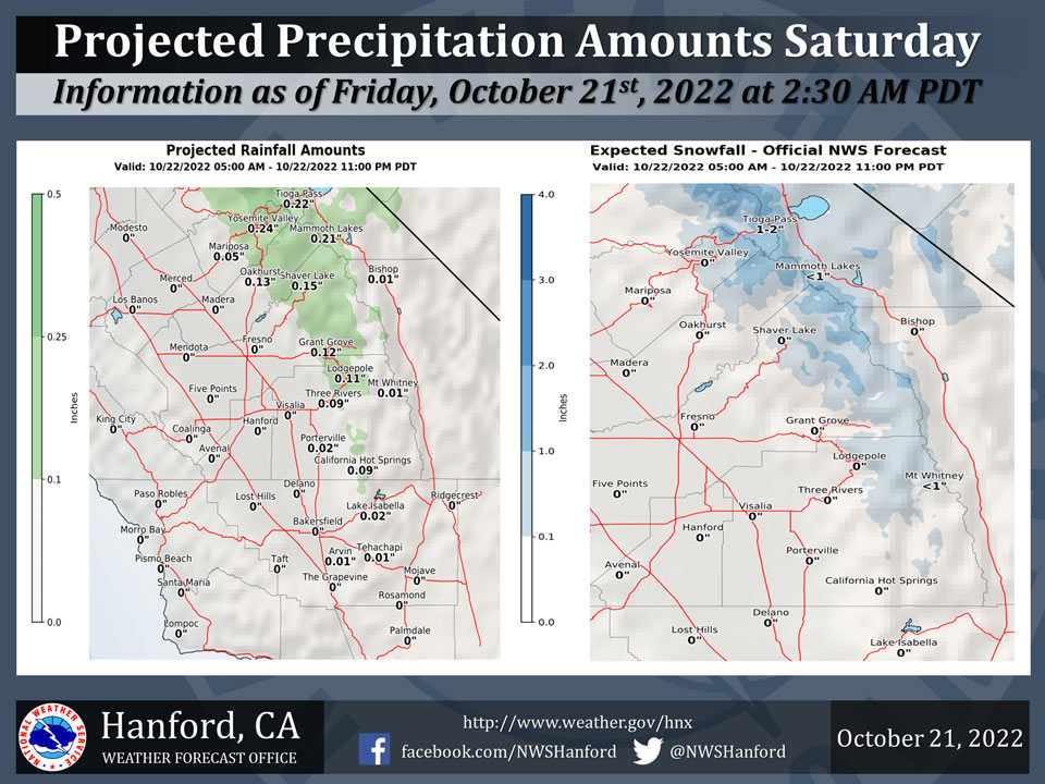
Projected Precipitation for Mariposa 0.05"
Projected Precipitation for Oakhurst 0.13"
Projected Precipitation for Yosemite Valley 0.24"
October 21, 2022 - The National Weather Service Hanford Office reports an upper trough will deepen over the Great Basin Saturday, resulting the possibility of precipitation for Central California.One to three inches of snow is possible in the Sierra Nevada above 8,000 feet while light rainfall is possible in the northern and eastern portions of the San Joaquin Valley.
The majority of this precipitation is expected on Saturday afternoon and evening.
Area Forecast Discussion
National Weather Service Hanford CA
315 AM PDT Fri Oct 21 2022
.SYNOPSIS...Dry weather and unseasonably warm temperatures well
continue today due to high pressure over the area. Expect
temperatures to fall to below normal over the weekend as a low
pressure center moving through the Great Basin brings much cooler
temperatures, increased winds and light precipitation to the area.
&&
.DISCUSSION...Persistent high pressure is providing our area with
an unseasonably warm airmass and near record high temperatures.
In fact, Madera did set a new record high temperature for October
20 reaching 90 DEG F which broke the previous record high of 89
DEG F set in 1973. One more unseasonably warm day is expected
today across our area before a cold upper low pressure center
which will drop southeast out of the Gulf of AK today and into the
PAC NW by Saturday. This upper low will then carve out a trough
over the Great Basin by Saturday night and push a strong cold
front through central CA Saturday afternoon and evening which
will bring much cooler temperatures to our area this weekend with
temperatures lowering to near normal levels by Saturday and below
normal levels on Sunday with high temperatures on Sunday expected
to be 20 to 25 DEG F below today's values. Latest NBM
probabilistic guidance is indicating that most of the San Joaquin
valley has between a 40 and 60 percent chance of high
temperatures below 70 DEG F on Sunday.
The system will also bring a chance of light precipitation to the
area Saturday morning through Saturday evening with Yosemite
National Park having the potential for a tenth to a third of an
inch of liquid precipitation. The snow level is progged to be
between 8500 and 9000 feet at the onset of the precipitation early
Saturday morning lowering to 6500 to 7000 feet Saturday night
when the precipitation is expected to taper off with only
isolated showers near the crest anticipated on Sunday. Between 1
and 3 inches of snow are possible above 8500 feet in Yosemite Park
on Saturday and Saturday night. Lesser precipitation amounts are
possible elsewhere with a few hundredths of an inch to two tenths
of an inch of precipitation possible in the Sierra Nevada south
of Yosemite Park and the higher Sierra foothills.
Another impact from this system will be a period of increased
winds across the south end of the upper Sierra Nevada as well as
across the mountains and desert area in eastern Kern County. A
Wind Advisory has been posted for these areas between 800 am PDT
Saturday and 11 pm PDT Saturday.
The medium range ensemble members are in good agreement with the
upper low and associated trough moving east of the Great Basin on
Monday with high pressure building back into CA and provide our
area with a warming trend through Tuesday. Another inside slider
type system is progged to drop into the Great Basin on Wednesday.
This will bring another cooling trend to our area with
temperatures lowering to slightly below climatological normals.
RH progs are showing that this system will be moisture deficient
and precipitation chances will be confined to isolated showers
near Yosemite Park. Another ridge is progged to push into CA on
Thursday and Friday which will provide for dry conditions and
another warming trend across our area late next week.
&&
.AVIATION...VFR conditions will prevail across the area for at
least the next 24 hours.
&&
.AIR QUALITY ISSUES...On Friday October 21 2022... Unhealthy for
Sensitive Groups in Fresno... Kern... Kings and Tulare Counties.
Source: NWS

