


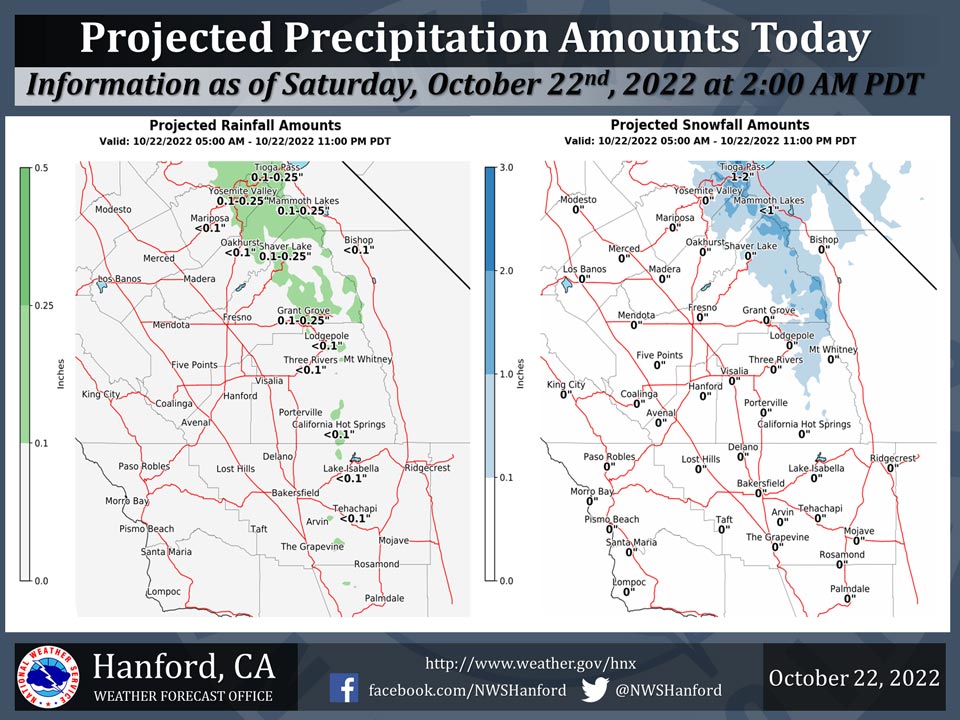
Projected Precipitation for Mariposa 0.05" Less Than 0.10"
Projected Precipitation for Oakhurst 0.13" Less Than 0.10"
Projected Precipitation for Yosemite Valley 0.24" 0.10" to 0.25"
October 22, 2022 - The National Weather Service Hanford Office reports an upper trough will deepen over the Great Basin today, resulting in the possibility of precipitation for Central California.One to two inches of snow is possible in the Sierra Nevada above 8,000 feet while light rainfall is possible in the Sierra foothills.
The majority of this precipitation is expected this afternoon and evening.
Area Forecast Discussion
National Weather Service Hanford CA
123 AM PDT Sat Oct 22 2022
.SYNOPSIS...
A trough of low pressure entering the Great Basin will lead to
significantly cooler temperatures today, along with gusty winds in
wind-prone areas of Central California. Cool temperatures are
expected to continue this week as another system approaches the
district by the middle of the week. Neither system is favorable to
generate much in the way of precipitation.
&&
.DISCUSSION...
A major change in the weather pattern is in store for Central
California as a stout inside-slider trough enters the Great Basin.
Models have been consistent in this leading to strong winds
through and below the mountain passes in Kern County, as well as
gusty winds through the Kern River Basin. See our Wind Advisory
for more details. Gusty conditions through Tioga Pass are also
likely to occur this morning through this evening as the upper jet
associated with this trough moves overhead. Some light showers
will be possible over the Sierra Nevada this afternoon as well, so
some minor accumulations of snowfall, likely 2" or less, will be
possible above 9,000 feet. Afternoon highs are forecast to plunge
15 degrees lower today compared to yesterday across the valley,
putting highs a couple degrees below average for Late October.
Highs may drop a several more degrees on Sunday across the valley
due to the modified airmass. Currently, we have a forecast high of
65* for Bakersfield on Sunday, which would be 12 degrees below
normal for the date.
As we head into next week, afternoon highs will attempt to rebound
back into the low to mid 70s by Tuesday, but this warming trend is
likely to be cut short as another system approaches the district.
Ensemble guidance is keeping this next trough slightly further
north and east of us compared to today's system, but it will
still knock down afternoon highs a few degrees Wednesday and
Thursday, and likely bring periods of breezy conditions across the
region. A slight chance of showers may accompany this system
Wednesday and Thursday in the northern portion of our CWA, but
precip totals would be marginal at best. After Thursday, the
cooler airmass is likely to remain in place over the valley.
Ensemble guidance hints at short wave ridging by next weekend
which could bump up highs a few degrees, but the overall pattern
remains progressive, so no significant warm up is expected at this
time.
&&
.AVIATION...Strong winds up to 45 knots over the Sierra Nevada
and Tehachapi Mountains through 06z Saturday. VFR conditions will
prevail across the area for at least the next 24 hours.
&&
.AIR QUALITY ISSUES...
ISSUED: 10/21/2022 14:32
EXPIRES: 10/22/2022 23:59
None.
Source: NWS

