


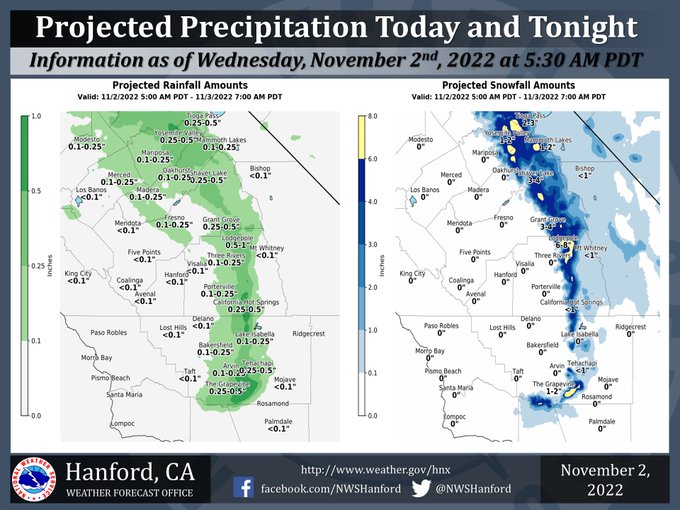
Mariposa and Oakhurst Projected Precipitation for Today: 0.10"-0.25".
Yosemite Valley Projected Precipitation for Today: 0.25"-0.50".
November 2, 2022 - The National Weather Service Hanford Office reports a trough of low pressure will be responsible for isolated to scattered showers in the San Joaquin Valley this afternoon.
A Winter Storm Warning is in effect for the Sierra Nevada until 11:00 P.M. this evening.
Light snow is possible over Tejon Pass and Tehachapi Pass tonight.
Area Forecast Discussion
National Weather Service Hanford CA
1208 AM PDT Wed Nov 2 2022
.SYNOPSIS...
A trough of low pressure will be responsible for scattered showers
in the San Joaquin Valley and Sierra Nevada foothills today. A
Winter Storm Warning remains in effect for the Sierra Nevada today
into tonight. Strong, gusty winds may develop in the Mojave Desert
Slopes today. An inch or less of snow is possible along I-5 over
Tejon Pass and along Highway 58 over Tehachapi Pass tonight.
&&
.DISCUSSION...
A trough of low pressure will deepen over the northern half of
California today. This trough of low pressure will be responsible
for scattered showers in the San Joaquin Valley and Sierra Nevada
foothills this afternoon. A Winter Storm Warning remains in effect
for the Sierra Nevada until 11 PM PDT this evening. Additional
snow accumulations should range from one to two inches from 4,000
to 5,000 feet, two to four inches from 5,000 feet to 6,000 feet,
and four to eight inches above 6,000 feet. The majority of this
snow will fall this afternoon. The pressure gradient should
tighten today, resulting in strong, gusty winds in the Mojave
Desert Slopes today. A Wind Advisory will likely be issued later
this morning for the Mojave Desert Slopes.
The trough of low pressure will deepen over Southern California
tonight. The probability of a trace or more of snow in Tehachapi
tonight is 52%. Right now, we are expecting an inch or less of
snow along Interstate 5 over Tejon Pass and along Highway 58 over
Tehachapi Pass tonight and Thursday morning. Be that as it may,
motorists should prepare for slick, icy roads and the possibility
of travel delays tonight and Thursday morning.
The trough of low pressure will move eastward into the Great Basin
Thursday afternoon. Temperatures may drop into the mid 30s in the
San Joaquin Valley Thursday night, leading to the possibility of
patchy frost. A fast-moving atmospheric disturbance embedded in
zonal flow aloft may impact the northern portion of the service
area this weekend. A stronger storm system may approach Central
California Tuesday.
&&
.AVIATION...
IFR or lower conditions are possible in the northern portion of
the San Joaquin Valley early this morning due to fog. MVFR or
lower conditions are likely throughout Central California this
afternoon in and near showers. MVFR or lower conditions are
possible in the Kern County mountains tonight in and near showers.
&&
.AIR QUALITY ISSUES...
On Wednesday, November 2nd, 2022, fireplace/wood stove burning
status is: no burning unless registered in Fresno, Kern, and Kings
Counties. Burning is discouraged in Madera, Merced, and Tulare
Counties, as well as in Kern (Greater Frazier Park Area) and
Sequoia National Park and Forest.
&&
.CERTAINTY...
The level of certainty for days 1 and 2 is high.
The level of certainty for days 3 through 7 is medium.
Certainty levels include low, medium, and high. Please visit
www.weather.gov/hnx/certainty.html for additional information
and/or to provide feedback.
&&
.HNX WATCHES/WARNINGS/ADVISORIES...
Winter Storm Warning until 11 PM PDT Wednesday for CAZ323-
326>328-330.
Source: NWS

