


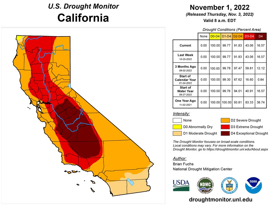
California and National Drought Summary for November 1, 2022
Summary
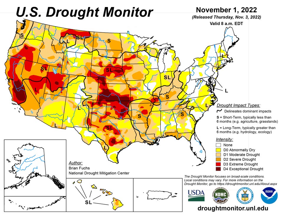
November 3, 2022 - An active weather pattern over the Midwest to southern Plains brought the most precipitation to those areas this week. Warm and dry conditions dominated the northern Plains and the upper Midwest where some areas are experiencing “flash drought” conditions that are not as common this time of year. Dryness over the Southeast is starting to impact more of the region while an active pattern has started over portions of the Pacific Northwest, bringing some moisture over the western portions of the region. Temperatures were coolest over the West and southern Plains and warmest over the northern Plains and into New England.
Northeast
Precipitation was localized during the last week with the greatest amounts taking place over New England where parts of Maine recorded 150-200 percent of normal. Through much of New York and Pennsylvania and into southern portions of the region, conditions were dry. Temperatures were warmer than normal over the region with departures of 8-10 degrees above normal in Maine and 2-4 degrees above normal over most of the rest of the area. With dryness in New York continuing, abnormally dry conditions were expanded this week in western portions of the state as well as into northern Pennsylvania. A new area of abnormally dry conditions was added in southern and western Pennsylvania as well. Some improvements were made in the coastal areas of Massachusetts as well as southern Connecticut and Rhode Island where moderate drought and abnormally dry conditions were impacted.
Southeast
Warmer than normal temperatures dominated most of the region with departures of 6-8 degrees above normal along the Gulf Coast of Florida and 2-4 degrees above normal through much of the rest of the region. Precipitation was mixed for the week in the area, with much of Florida and along the Atlantic Coast less than 50% of normal while areas of Alabama, Mississippi, Tennessee and the Carolinas had precipitation that approached 150-200% of normal. Short-term dryness has settled in over much of the eastern Carolinas as well as Georgia and northern Florida. Mostly degradations were made this week as the short-term dryness has started to impact the region. Abnormally dry conditions were expanded in the Carolinas with moderate drought expanded there as well. In South Carolina, the severe drought was reduced and some improvements were made to moderate drought. Northern Florida and southern Georgia had moderate and severe drought expanded while abnormally dry conditions filled in more of northern Florida and eastern Georgia. A new area of moderate drought was added to eastern Georgia and southern South Carolina. Alabama and Mississippi had rains that allowed for some improvements to severe and moderate drought and a reduction of abnormally dry conditions in the southern and northern portions of those states.
South
Welcome rains over north and south Texas, Arkansas, northern Louisiana and into southern Oklahoma helped to build on recent precipitation events in some of these areas. Portions of north Texas and into southern Arkansas and northern Louisiana recorded 200-400% of normal precipitation for the week. Southern Louisiana as well as west Texas and the Oklahoma panhandle remained dry. Cooler than normal temperatures through much of Texas and Oklahoma as well as western Arkansas and Louisiana helped to slow down further drought development for this week and even allowed for some improvements. A full category improvement to drought levels was made over northern Texas and into southeast Oklahoma. In Arkansas, extreme and severe drought were improved. Extreme drought was removed from Tennessee this week with improvements in the western portion of the state while abnormally dry conditions expanded in the central and northeast portion of the state. Louisiana had some adjustments to the severe drought in the south as the western portion improved but the area expanded to the east. Additional improvements were made to moderate and severe drought in east Texas and to abnormally dry conditions in south Texas.
Midwest
The Midwest had a stark contrast in precipitation for the week with the northern and western portions quite dry, the central areas quite wet, and the eastern areas dry. The greatest precipitation was recorded from central and eastern Missouri into Illinois and western Indiana where over 300% of normal precipitation was recorded. Temperatures remained mild in the region with almost all areas above normal for the week, outside of some areas of Missouri and Illinois where rains kept the temperatures below normal. Northern Minnesota had temperatures 6-8 degrees above normal while the eastern portions of the region were 2-4 degrees above normal. Missouri had the most improvements as rains over the current period as well as the last few weeks allowed for a full category of improvement in central and eastern portions of the state. Improvements were also made in portions of Illinois and Indiana where moderate drought and abnormally dry conditions improved. Degradations were made in Iowa and Minnesota where severe drought expanded over western Iowa and extreme drought expanded over southern Minnesota and northwest Iowa. Abnormally dry and moderate drought also expanded over portions of northern and eastern Minnesota as well as southeast Iowa. Continued dryness in Ohio allowed for the expansion of both moderate drought and abnormally dry conditions.
High Plains
Temperatures were well above normal over the northern and eastern portion of the High Plains and below normal in the west. Temperatures were 8-10 degrees above normal in the Dakotas and 2-4 degrees above normal in Nebraska and northern Kansas. Portions of Wyoming, Colorado and western Nebraska were cooler than normal with temperatures 2-4 degrees below normal. It was quite the dry week in the region as there were only a few pockets of rain in southeast South Dakota, northeast Nebraska and into north-central Kansas. Flash drought conditions are impacting the region, especially in the Dakotas where warm, dry and windy conditions have provide ideal harvest conditions but have started taking a toll on the region. In the Dakotas, a broad expansion of severe drought conditions took place this week. Moderate drought also expanded in eastern South Dakota and into southern portions of the state. Continued dryness over Kansas, where portions of southwest Kansas had their driest October on record, allowed for the expansion of extreme and exceptional drought this week. On the plains of Colorado, moderate drought and abnormally dry conditions continue to expand.
West
Temperatures for the week were cooler than normal over most of the region, with departures of 4-6 degrees below normal over the southwest. Warmer than normal conditions were recorded in the Pacific Northwest as well as across the northern portion of the region where temperatures were 4-6 degrees above normal with some even greater departures in Montana. Wetter than normal conditions were recorded in the Pacific Northwest as well as in western Colorado, northern Oregon, and into northern Idaho. The continued wet pattern allowed for some improvements in northeast New Mexico to the moderate, severe, and extreme drought conditions even as long-term issues remain. Western Colorado had improvements to moderate and severe drought as the ongoing wet pattern and early snows have allowed for improvements. Washington received enough rain to start showing improvements to the moderate and severe drought in the west while northern portions of the state had moderate drought expand.
Caribbean
The last remaining area of abnormally dry conditions was removed from Puerto Rico.
A plume of tropical moisture delivered heavy precipitation across the U.S. Virgin Islands, with rainfall rates generally peaking on October 26. As a result, neither dryness nor drought exists across the USVI for the first time this year. During the drought-monitoring period ending on the morning of November 1, rainfall across the USVI generally totaled 2 to 4 inches or more. Two volunteer (CoCoRaHS) observers on St. John received more than 4 inches of rain. King Airport on St. Thomas reported 4.80 inches of rain during the last 5 days of October, including 4.29 inches—wettest day since July 31, 2019—on the 26th. Six of eleven volunteer observers on St. Croix registered more than 3 inches of rain during the week. Although some lingering concerns exist with respect to low groundwater levels, all three U.S. Geological Survey well sites have exhibited significant improvement. At the Adventure 28 Well on St. Croix, depth to water—which had been 35.8 feet in mid-September—improved to 29.0 feet by November 2.
Pacific
No changes in Alaska this week.
In Hawaii, the northern portion of Kauai had a full category improvement. Molokai had the drought gradient shift to the southwest as some improvements were made. Lanai had a full category improvement in the west-central portion of the island. On Maui, the Kihei area had a full category improvement, the central valley is still very dry and exceptional drought is still very dominant in this localized region. On Kahoolawe, the south side of the island was improved and there was a full category improvement on the Big Island on the eastern slopes.
An active weather pattern across the western Pacific included the formation of Tropical Storm Banyan. Although a heavily sheared system, the disturbance that would become Banyan resulted in flooding rain and damaging winds in the Republic of Palau. In fact, October rainfall records were broken for several locations in the Republic of Palau, including Airai (28.49 inches; previously, 27.58 inches in 2021) and Koror (27.46 inches; previously, 22.47 inches in 1974). More than one-quarter (7.32 inches) of Airai’s October rainfall occurred on the 31st, in conjunction with the tropical cyclone. October wetness extended to many locations in the Federated States of Micronesia, including Yap (26.49 inches). With nearly 2 feet of rain in October, Pohnpei’s year-to-date total through the end of October climbed above 210 inches, nearly 160% of normal. The only FSM location experiencing drought was Kapingamarangi, where severe drought (D2-SL) persisted and October rainfall totaled less than 3 inches—roughly one-third of normal. Abnormal dryness (D0-S) was retained for Lukunor, FSM, where near-normal October rainfall followed significantly below-normal precipitation in August and September.
October was a wet month across the Mariana Islands and much of the Republic of the Marshall Islands. In the Marianas, October rainfall at Guam International Airport totaled 17.12 inches, 134% of normal. In the RMI, abnormal dryness (D0-S) was retained for Wotje, as a 2.06-inch total during the most recent drought-monitoring period (ending November 1) followed 3 weeks with less than an inch of rain. In contrast, October rainfall at other locations in the RMI ranged from 18 to 22 inches at Kwajalein, Majuro, and Mili. In late October, very wet conditions developed across American Samoa, where Pago Pago International Airport received rainfall totaling 7.65 inches from October 26-28.
Looking Ahead
Over the next 5-7 days, it is anticipated that the Pacific Northwest will remain in an active pattern, with greatest precipitation anticipated along the coast. The Rocky Mountains also look to stay in an active pattern, with up to an inch of precipitation anticipated over much of western Colorado and Wyoming as well as into Utah. A large frontal system is anticipated over much of the Midwest, with areas of the upper Midwest expected to receive over 1.50 inches of rain. The wet pattern over the South will continue as well with much of the lower Mississippi basin anticipating rainfall of over 1 inch. Temperatures during this period show much of the eastern U.S. having above-normal temperatures, with the greatest anomalies over the Great Lakes where high temperatures could be 15-18 degrees above normal. Cooler than normal temperatures are anticipated over the West with departures of 6-9 degrees below normal over California to Arizona.
The 6-10 day outlooks show that temperatures are anticipated to be warmer than normal over the eastern half of the U.S. with the greatest chances over the East coast and into the Mid-Atlantic. Cooler than normal temperatures are anticipated over much of the West with the best chances of below normal temperatures over the northern Rocky Mountains and into the Great Basin. The likelihood of drier than normal conditions are greatest over the Midwest into the lower Mississippi valley. The best chances for wetter than normal conditions are over the southeast coastal areas, the northern Plains, upper Midwest and into the Great Basin and California.
Author(s):
Brian Fuchs, National Drought Mitigation Center
Brad Rippey, U.S. Department of Agriculture
Dryness Categories
D0 Abnormally Dry—used for areas showing dryness but not yet in drought, or for areas recovering from drought.
Drought Intensity Categories
D1 Moderate Drought
D2 Severe Drought
D3 Extreme Drought
D4 Exceptional Drought
Drought or Dryness Types
S Short-term, typically less than 6 months (agriculture, grasslands)
L Long-term, typically more than 6 months (hydrology, ecology)
SL Area contains both short- and long-term impacts
Source: National Drought Mitigation Center

