


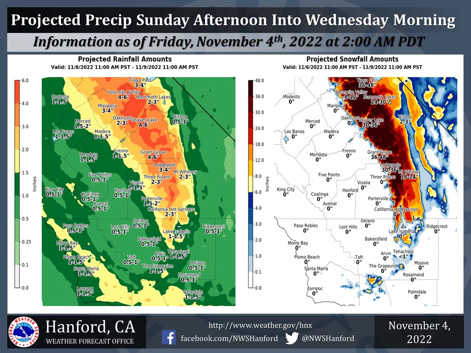
Mariposa, Sunday Through Wednesday Projected Precipitation: 3.00" to 4.00"
Oakhurst, Sunday Through Wednesday Projected Precipitation: 2.00" to 3.00"
Yosemite Valley, Sunday Through Wednesday Projected Precipitation: 4.00" to 6.00"
November 4, 2022 - The National Weather Service Hanford Office reports a major storm system will impact Central California late this weekend through early next week, resulting in significant precipitation.
A Winter Storm Watch is in effect for the Sierra Nevada.
The majority of this precipitation will fall Tuesday.
Area Forecast Discussion
National Weather Service Hanford CA
254 AM PDT Fri Nov 4 2022
.SYNOPSIS...
A couple of cool, dry days are expected to occur through Saturday
before a slow moving, storm system begins to impact the region on
Sunday. This system is forecast to bring widespread valley rain
and mountain snow through Wednesday morning, as well as below
average afternoon high temperatures.
&&
.DISCUSSION...
Mainly clear skies across central California this morning. Some
high clouds crossing the district from north to south. Expect a
cool frosty with temperatures moving into the mid 30s in parts of the
San Jouquin valley. Colder in the high desert with Edwards Base
near the freezing mark. Ensemble models in fair agreement with the
next storm system moving into California later this weekend.
Satellite images show an anticyclone in the east Pacific with an
atmospheric river of moisture moving into the Pacific Northwest.
An upper trough will move through the Gulf of Alaska bringing the
moisture southward into North Cal Saturday. Strong westerly winds
will continue to drive the moisture over central Cal Sunday. This
storm system will affect the district for several days perhaps
until Wednesday due to several upper level disturbances moving
through the trough. Latest models are a bit more progressive and
initial disturbance brings the moisture and precipitation into the
north sectors of the Yosemite area Saturday night. The upper
trough off the Pac NW coast will dig southward along the CA coast
bringing another surge of moisture with strong westerly winds
into central CA Sunday night and continue pushing south into SCal
late Monday and Tuesday. Precipitation diminishing Wednesday
morning as the trough moves east of the sierra into Nevada.
In terms of snow, snow levels are expected to start around 8500
feet Sunday afternoon and fall to about 5000 feet by late Monday
morning as the cold front passes through. This slow moving storm
is forecast to bring 2-3 feet of snow in the Sierra Nevada through
Wednesday morning, with isolated accumulations up to 4 feet above
8000 feet, so a Winter Storm Watch has been issued Sunday PM
through Wednesday AM in the Sierra Nevada.
The cold frontal passage will be the best opportunity for high
snowfall rates in the mountains along with moderate rainfall rates
in the valley and adjacent foothills. Strong westerly winds in
the Sierra Nevada accompanying the front up to 50 mph coupled
with intense snowfall Monday morning may make travel difficult.
Valley rain and mountain snow is likely to continue after the
cold frontal passage, but with lower intensity. Currently,
blended model guidance is favoring light precip to begin in the
northern most sections of the CWA Saturday evening, with the
precip extending southward Sunday. Gradients tightening ahead of
the cold front Sunday evening may lead to windy conditions through
and below the mountain passes in Kern County.
Ensemble guidance suggests the trough/surface low slowly pushing
inland sometime on Monday afternoon through Tuesday morning. The
ensemble forecast of a slow movement of the system is consistent
with NBM forecasting continuous light to moderate precip across
Central California on Tuesday. NBM has snow levels dropping to
about 4500 feet in a few areas Tuesday afternoon, to as low as
3000 feet by mid morning Wednesday, which could bring a couple of
inches of snow across Yosemite Valley. Also, this cold air aloft
could provide enough instability for a thunderstorm or two in the
San Joaquin Valley Tuesday afternoon. The trough is currently
progged to exit Central California by Wednesday afternoon.
&&
.AVIATION...
VFR conditions will prevail through at least the next 24 hours.
&&
.AIR QUALITY ISSUES...
ISSUED: 11/03/2022 15:02
EXPIRES: 11/04/2022 23:59
On Friday November 4 2022...Fireplace/Wood Stove Burning Status
is: No Burning Unless Registered in Fresno and Kern Counties.
Burning Discouraged in Kings... Madera... Merced and Tulare
Counties... and Kern (Greater Frazier Park Area) and Sequoia
National Park and Forest.
Source: NWS

