


California and National Drought Summary for December 6, 2022
Summary
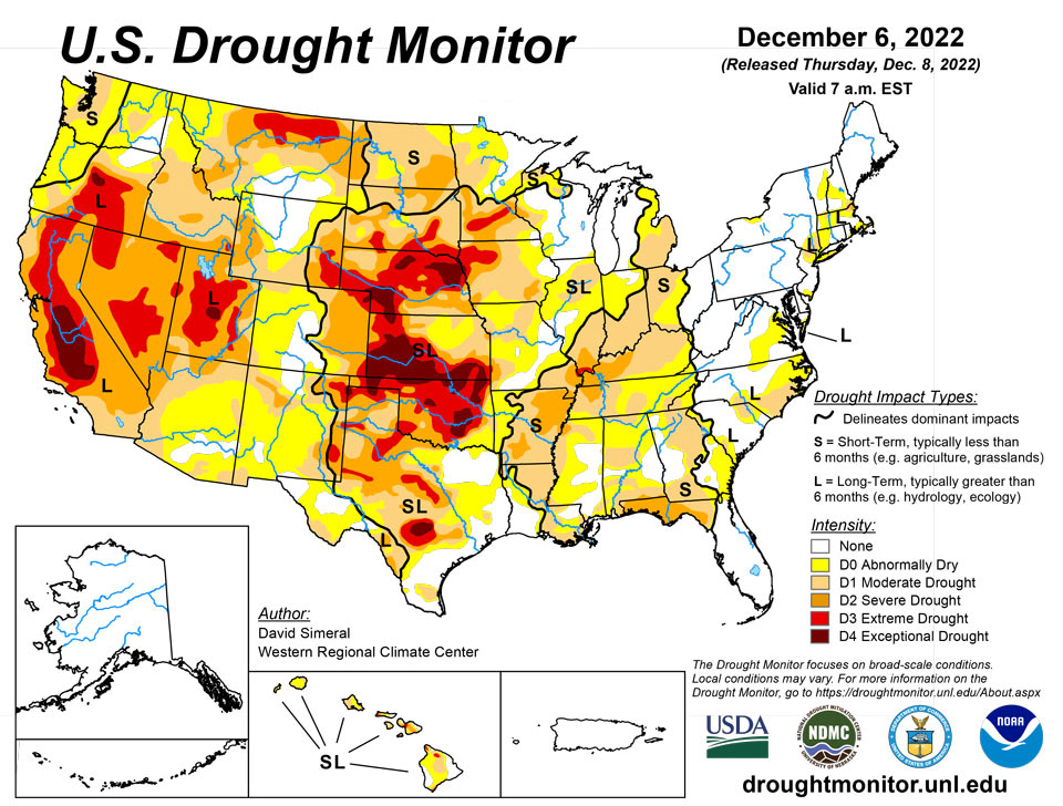
December 8, 2022 - This U.S. Drought Monitor (USDM) week saw an active storm pattern across much of the Western U.S. as well as another round of isolated heavy rainfall across portions of the South and Southeast. Out West, several rounds of Pacific moisture streamed into the region bringing heavy rains to the lower elevations of the Pacific Coast Ranges and snowfall to the higher elevations of the Sierra Nevada, Klamath Mountains, Cascades, northern Great Basin, and the central and northern Rockies. For the multi-day storm event, the heaviest snowfall accumulations were observed in the Sierra Nevada where up to four feet was observed including at the Central Sierra Snow Lab, which reported a 7-day snowfall total of 48.8 inches. Moreover, the storms boosted basin-wide snow water equivalent (SWE) to well above normal levels in the Sierra Nevada drainage basins and basins across the Intermountain West and Pacific Northwest, according to the National Resources Conservation Service (NRCS) SNOTEL network. Along the Central California coast in the Santa Lucia Range (south of Monterey), 7-day rainfall accumulations ranged from 4 to 11+ inches—helping to reduce longer-term precipitation deficits (past 24 months) that ranged from 8 to 20+ inches after this week’s storms. In the Desert Southwest, locally heavy rainfall was observed in southern Arizona and west-central New Mexico in association with sub-tropical moisture that moved into the region on Saturday with isolated areas receiving 2 to 3+ inches of rain. The rainfall improved soil moisture levels and helped to boost precipitation totals during the past 12-month period to normal to above-normal levels across much of the southern portion of Arizona. In the Northern Plains, light snowfall (2 to 6 inches) was observed in the Dakotas and eastern Montana in addition to the passage of an Arctic front early this week, which dropped temperatures into the single digits in North Dakota. In the Midwest, a wintery mix of rain, freezing rain, and snow impacted southern Wisconsin while light-to-moderate snowfall accumulations (2 to 6 inches) were observed in Minnesota and Upper Peninsula Michigan. In the Interior Deep South, locally heavy showers (2-to-4-inch accumulations) brought some relief to drought-affected areas of northern Alabama and Georgia as well as southeastern Tennessee, and southwestern North Carolina. In the Northeast, light-to-moderate snowfall accumulations (1 to 4 inches) were observed last week with the heaviest accumulations in Upstate New York. In Maine and New Hampshire, strong winds and shower activity (1 to 2 inches) impacted the region last week causing power outages in areas of Maine. In the South and Southeast, locally heavy rainfall was observed across a west-to-east band extending from northern Mississippi to northern Georgia. The storms helped to reduce short-term precipitation deficits (past 30-60 days) in some areas and boosted streamflows and soil moisture to above-normal levels.
Northeast
Some minor changes were made on the map in Upstate New York where an area of Abnormally Dry (D0) was introduced to reflect short-term precipitation shortfalls and low streamflow levels including on Allen Creek in Monroe County where current streamflow levels were in the 6th percentile, according to the U.S. Geological Survey (USGS). For the past 30-day period, precipitation has generally been above normal across much of the region with exception of some dry pockets in areas within proximity to the coast. To date, only 2% of the Northeast Region is currently depicted in drought on the map. During the past week, precipitation accumulations (liquid) were generally light to moderate (<2.5 inches) with the heaviest accumulations observed in Maine, while most of the southern extent of the region was dry. Average temperatures for the week ranged from 2 to 8 deg F above normal with the greatest departures observed in Upstate New York.
Southeast
During the past week, light-to-heavy rainfall accumulations (1 to 6+ inches) were observed across the region. The highest totals were observed in northern portions of Alabama and Georgia, which led to removal of areas of Severe Drought (D2) and reduction of areas of Moderate Drought (D1). The recent rains boosted streamflows to above-normal levels as well as replenished soil moisture, with the latest NASA SPoRT soil moisture product (0-40 cm depth) showing levels ranging from the 70th to the 90th percentile. Further to the South, pockets of very dry soils were showing up in downstate areas of Alabama and Georgia as well as in the Florida Panhandle, where soil moisture ranged from ~2nd to the 20th percentile. For the week, average temperatures were 2 to 8 deg F above normal with the greatest departures observed in the southern half of the region, while North Carolina and Virginia temperatures were a few degrees below normal.
South
In the South, improvements to drought-related conditions were made on the map in areas of Arkansas, Mississippi, and Tennessee in response to rainfall over the past 30-day period. Elsewhere, some minor degradations occurred in South Texas and the Oklahoma Panhandle. Across the western portion of the region, generally dry conditions prevailed, while the eastern half saw rainfall accumulations ranging from 1 to 4+ inches with the highest totals logged in northeastern Mississippi and southern Tennessee. Average temperatures for the week were generally above normal (1 to 10 deg F) with the greatest anomalies observed in the Trans Pecos region of Texas and along the central Gulf Coast Region. In contrast, eastern Oklahoma, Arkansas, and Tennessee experienced average temperatures that were near to slightly below normal.
Midwest
For the week, precipitation accumulations were light to moderate (1 to 2+ inches) with the heaviest accumulations observed in southern Kentucky. In Minnesota, Wisconsin, and Michigan, light-to-moderate snowfall accumulations (1 to 6 inches) were observed. Looking at the regional snowfall analysis for the Northern Great Lakes Region, the NOAA National Operational Hydrologic Remote Sensing Center (NOHRSC) is currently reporting that the region is 38.4% snow-covered with an average depth of 1.0 inches and a maximum depth of 15 inches. On the map, areas of Abnormally Dry (D0) were reduced in eastern Ohio and northern Indiana where short-term conditions have improved in response to recent rains. Conversely, areas of Moderate Drought (D1) expanded in southern and northern Illinois where shorter-term precipitation deficits exist (past 30-90-day period) as well as areas of below-normal soil moisture that are showing up on various soil moisture models. In west-central Minnesota, an area of Severe Drought (D2) expanded where significant precipitation deficits (9-12 inches) have been observed during the past 6-month period. For the week, average temperatures were mainly below normal across the region with the greatest departures (-10 deg F below normal) observed in northern Minnesota.
High Plains
On this week’s map, improvements were made in northwestern Colorado and Wyoming. In Wyoming, recent storms delivered beneficial snowfall to the Teton and Wind River ranges leading to reduction in areas of Moderate Drought (D1). Moreover, the drainage basins in those ranges, the Snake Headwaters and Upper Green, were reporting SWE percentage of median levels of 129% and 114%, respectively. Additionally, areas of Moderate Drought (D1) were reduced in northwestern Colorado in response to improving conditions from recent storms and above-normal snowpack conditions including in the White-Yampa Basin (122% of median). In Kansas, continued dry conditions led to minor expansion of areas of Extreme Drought (D3) and Exceptional Drought (D4) in western Kansas. Looking at the past 9-month period in the western half of Kansas, precipitation deficits ranged from 3 to 12+ inches. For the week, average temperatures were mainly below normal, with the greatest departures (10 to 15 deg F below normal) observed in North Dakota and north-central Wyoming. In terms of precipitation, the region was generally dry, although some significant mountain snowfall was observed in western Wyoming and in the Rockies of Colorado, while lesser accumulations were reported in areas of the Dakotas.
West
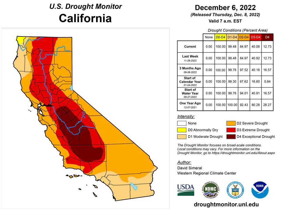
Out West, back-to-back storm systems delivered significant rainfall accumulations to the lower elevations of California, Oregon, and Washington as well as heavy mountains snows to the Sierra Nevada, Klamath Mountains, and areas of the Cascades. Moreover, moderate-to-heavy snowfall accumulations were observed in the ranges of the northern Great Basin and the central and northern Rockies. The beneficial rains from the storms led to some minor improvements on the map along the Central Coast of California where rainfall totals exceeded 10 inches in isolated areas of the Santa Lucia Range. Elsewhere in California, no changes were made on the map this week. However, some targeted improvements are likely next week after a more thorough assessment of the impact of the storms in juxtaposition to the significant longer-term precipitation deficits across the state. Nonetheless, California’s snowpack is off to a positive start with the California Cooperative Snow Surveys reporting (12/6) statewide SWE at 171% of normal, with the Northern Sierra at 156%, Central Sierra 160%, and Southern Sierra 203% of normal. In the Southwest, some improvements were made on the map in drought-affected areas in southern Arizona in response to this week’s round of subtropical moisture that delivered locally heavy rains—improving soil moisture and streamflow conditions. In the Intermountain West, improvements were made on the map in areas of Extreme Drought (D3) in central and eastern Nevada as well as in Utah where conditions have improved during the past 6-month period across various indicators including soil moisture, streamflows, shallow groundwater, and precipitation. In southwest Montana, recent snowfall and overall improving conditions on various drought metrics led to removal of areas of Moderate Drought (D1) on the map. For the week, the northern half of the region experienced cooler-than-normal temperatures (2 to 20 deg F below normal) with the greatest departures observed along the northern border with Canada.
Caribbean
In Puerto Rico, light-to-moderate rainfall accumulations (1 to 3 inches) were observed during the past week—the territory remained drought-free with no changes made on the map.
St. Croix (Henry Rohlsen AP) reported 0.07 inches of rain this week. Despite recent days with dry conditions, the depth to water level at Adventure 28 Well (St. Croix, USVI) on December 6 was 25.53 ft below land surface due to significant rainfall in the past few months. A significant decrease of depth of water level has been observed since September 7 (when it was 35.4 ft below land surface). Thus, St. Croix remained free of dryness or drought.
Similarly, on St. Thomas (Cyril E. King Airport), 0.17 inches of rain was observed this week. This week, the depth to water level at Grade School 3 well (St. Thomas, USVI) was 4.9 ft below land surface. However, a slight increase from November 8 to this week was observed. In contrast, there has been a significant decrease in depth to water level since mid-August (when it was over 18 ft). Thus, St. Thomas remains at the status quo of drought-free conditions this week. On St. John, at Rafe Boulon (VI-SJ-3: Windswept Beach), 0.35 inches of rain was reported this week. The depth to water level at Susannaberg DPW 3 well (St. John, USVI) this week was 7.88 ft below land surface. The depth to water level at Susannaberg DPW 3 well was over 23 ft at the beginning of September. Even though there was missing data between October 25 and November 16, recent observations show a significant decrease from November 16 to date. Thus, St. John continues to be drought free this week.
Pacific
In Alaska, no changes were made on the map and the state remained drought-free. Looking at the month of November in Alaska, anomalously warm temperatures prevailed across much of the state. On the North Slope, Utqiagvik observed its 6th warmest November on record (since 1920) and 7th warmest autumn. Conversely, Southeast Alaska experienced cooler-than-normal temperatures (3 to 9 deg F) for November. According to the NRCS SNOTEL network, above-normal SWE levels were reported across all observed sub-regions (4-digit HUC) and are as follows: Lower Yukon River 132%, Middle Yukon River 128%, Upper Yukon River 184%, South Central Alaska 109%, and Southeast Alaska 123%.
In the Hawaiian Islands, some minor degradations occurred on this week’s map including introduction of an area of Extreme Drought (D3) in the Kohala Mountains where satellite-based indicators (NDVI) were showing areas of poor vegetation health conditions, with similar reports of poor pasture conditions being reported by ranchers in the region. Elsewhere, areas of Moderate Drought (D1) were added in Kauai and Oahu where recent rainfall and streamflow levels have been below normal.
Most of the Marshall Islands remained free of drought or abnormal dryness this week. On Wotje, 2.46 inches of rain was reported this week. Even though Wotje received only 0.80 inches of rain last week, it had 4.40 inches of rain the week before (i.e., the week of November 22). Dry conditions (less than 2 inches of rain) were observed through 8 of the past 12 consecutive weeks on Wotje, resulting in a continuation of short-term abnormal dryness. Kwajalein received 1.16 inches of rain this week. Last week’s rainfall total was 1.05 inches. This week is the second consecutive week with less than normal rainfall. However, 6.05 inches of rain was recorded on Kwajalein two weeks ago. Thus, Kwajalein remained in the status quo of drought-free conditions for this week. Ailinglapalap received only 0.88 inches of rain this week with one day missing. However, wet conditions have been observed in the past three weeks. In addition, because of the wet conditions in the past few months, Ailinglapalap remained drought free. Jaluit observed 1.1 inches of rain this week but had wet conditions in the previous three weeks (i.e., over 2 to 3 inches of rain each week). On Majuro, only 0.71 inches of rain was reported this week. Even though relatively drier conditions prevailed at Jaluit and Majuro, both remained drought free due to wet conditions in the past few weeks. This week 2.16 inches of rain was reported on Mili, which remains free of drought. No depiction was made for Utirik due to missing data.
Pago Pago reported 2.46 inches of rain this week. In addition, Siufaga Ridge (NPS in American Samoa) and Toa Ridge (NPS in American Samoa) reported 0.90 and 2.19 inches of rain, respectively. Because of wet conditions in the past few weeks, American Samoa remained free of drought conditions. Palau IAP (Airai) reported 2.18 inches this week. Koror COOP station also reported 0.11 inches of rain with five days missing. However, they remained free of drought due to the wet conditions in the previous weeks.
Palau IAP (Airai) reported 2.18 inches this week. Koror COOP station also reported 0.11 inches of rain with five days missing. However, they remained free of drought due to the wet conditions in the previous weeks.
This week, 0.82 inches of rain was reported on Yap with two days missing. Below-normal rains were also reported in the past three weeks. Thus, short-term abnormal dryness continues on Yap. On Ulithi, only 0.66 inches of rain was reported this week with one day missing. However, over 2 inches of rain was reported on Ulithi for the past two weeks, so it remained free of dry conditions. On Kapingamarangi, 2.74 inches of rain was reported this week (with two days missing). However, Kapingamarangi has been dry in the past several weeks, and therefore it remains in short- and long-term severe drought. On Lukunor, only 0.43 inches of rainfall was reported this week (with four days missing). Drier-than-normal conditions were observed in the last five to six weeks. Thus, Lukunor remains in abnormally dry conditions. Generally, wet conditions have prevailed at Pohnpei in the past few months. This week, only 1.79 inches of rain was reported (with two days missing), so Pohnpei remains free of dryness. On Pingelap, no rain was reported this week (seven days missing). However, wet conditions prevailed in the past few weeks, allowing the island to remain drought free. On Woleai, only 1.08 inches of rain was reported this week, with one day missing. However, because Woleai was wet in the past three weeks, it remained drought free. At Chuuk, only 0.78 inches of rain was observed this week with one day unaccounted for, but the islands remain free of dryness due to wet conditions in the previous weeks. On Fananu, 0.24 inches of rain was reported this week (with three days missing), allowing the island to remain free of drought or abnormal dryness because of the significant amounts of rain in the previous two weeks (i.e., 7.64 and 2.25 inches of rain). On Nukuoro, 5.91 inches of rain was reported this week. In addition, the island received 4.77, 4.38, and 1.87 inches of rain in the past three weeks, allowing Nukuoro to be free of drought or abnormal dryness.
The drought-free conditions have continued across the Mariana Islands this week. Rainfall reported on Guam was 2.93 inches, allowing the island to remain free of dryness or drought. Wet conditions continued at Rota, which received 2.02 inches of rain this week. In addition, the amounts of rainfall observed on Saipan (IAP, manual gauge), Saipan (ASOS), and Saipan (NPS) were 1.67, 1.52, and 0.35 inches, respectively. Thus, Saipan remains drought free this week.
Looking Ahead
The NWS WPC 7-Day Quantitative Precipitation Forecast (QPF) calls for moderate-to-heavy precipitation accumulations (including heavy snowfall accumulations) ranging from 2 to 4+ inches (liquid) across much of the Cascades of Oregon and Washington, Klamath Mountains, Coast Ranges of Northern California, and the Sierra Nevada Range-similar to last week’s QPF for the West Coast region. In the Intermountain West, 1-to-2-inch (liquid) accumulations are expected in the Rocky Mountains of Colorado, while lesser accumulations are expected in the Wasatch Range of Utah and the ranges of central and northern Idaho. Elsewhere in the conterminous U.S., another round of heavy precipitation accumulations is expected in Arkansas, southern Missouri, northern Mississippi, and eastern portions of Kentucky and Tennessee (3-to-5+-inches liquid). In areas of the Midwest and Northeast, accumulations are expected to be generally <1-inch. The CPC 6-10-day Outlooks call for a moderate-to-high probability of above-normal temperatures for the eastern half of the conterminous U.S. with near-normal temperatures across much of the Plains states, while the Western U.S. is forecasted to be below normal. In terms of precipitation, above-normal precipitation is expected across most of the conterminous U.S. except for western Texas and areas of New Mexico.
Author(s):
David Simeral, Western Regional Climate Center
Tsegaye Tadesse, National Drought Mitigation Center
Dryness Categories
D0 Abnormally Dry—used for areas showing dryness but not yet in drought, or for areas recovering from drought.
Drought Intensity Categories
D1 Moderate Drought
D2 Severe Drought
D3 Extreme Drought
D4 Exceptional Drought
Drought or Dryness Types
S Short-term, typically less than 6 months (agriculture, grasslands)
L Long-term, typically more than 6 months (hydrology, ecology)
SL Area contains both short- and long-term impacts
Source: National Drought Mitigation Center

