


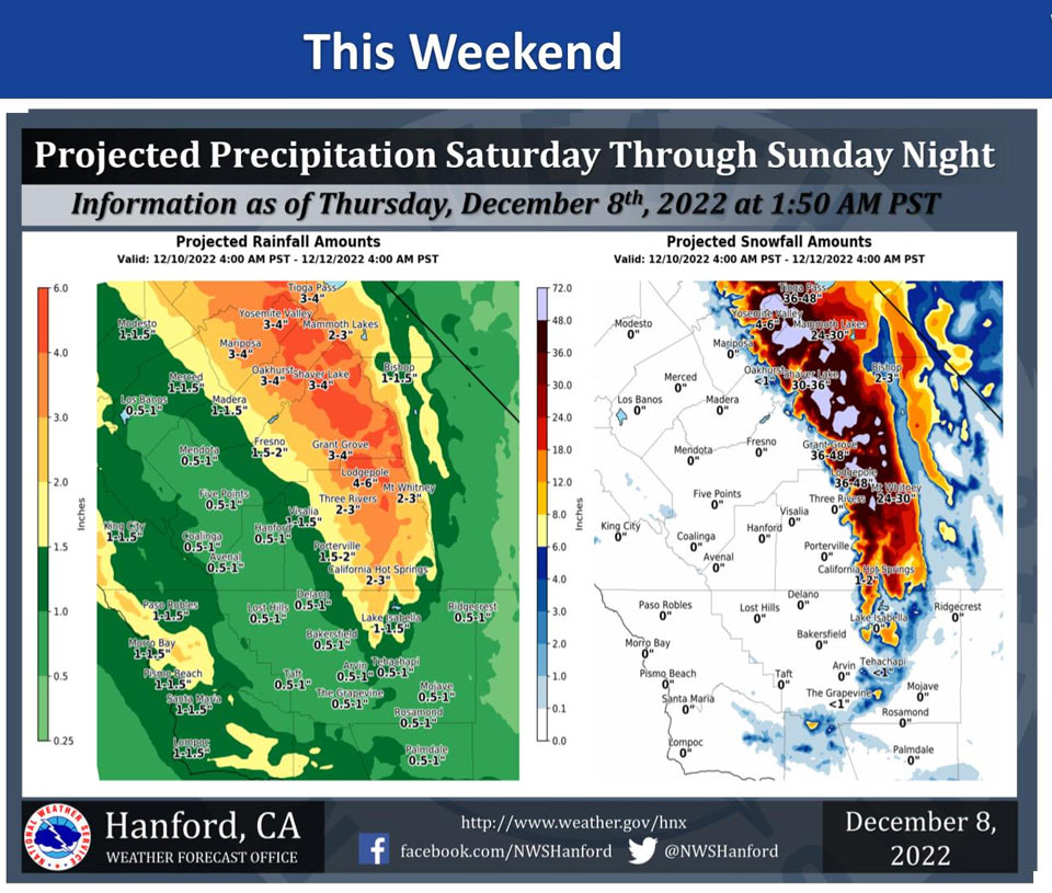
Projected Precipitation for Mariposa 3.00"- 4.00"
Projected Precipitation for Oakhurst 3.00"- 4.00"
Projected Precipitation for Yosemite Valley 3.00"- 4.00"
December 8, 2022 - The National Weather Service Hanford Office reports a strong storm system will impact Central California this weekend.
The majority of precipitation associated with this storm system will fall Saturday night and Sunday.
Snow levels will start at around 4,000 feet Saturday, before rising to about 6,000 feet Saturday evening into Sunday morning. Snow levels will drop to around 3,000 feet by Sunday evening.
Area Forecast Discussion
National Weather Service Hanford CA
159 AM PST Thu Dec 8 2022
.SYNOPSIS...
Dense fog this morning which will clear out by afternoon. A weak
trough will slide through late Thursday night into Friday morning. A
second but stronger trough will slide in Friday night and less
through the weekend. Freezing temperatures likely for the Valley for
much of next week.
&&
.DISCUSSION...
A Dense Fog Advisory is in effect as dense fog is and will cover
most of the Valley this morning with visibility down to 1/2 mile or
less in most spots before burning off by around 19Z. The fog is due
to the significant moisture that has accumulated from the storms
that began the month. In addition, a weak ridge is over the Valley
which is providing sinking air or subsidence which is conducive for
fog.
Both the GEFS and European model ensembles have good agreement
regarding two troughs that are expected for the weekend. The first
trough moves in late tonight before sliding out of the area on
Friday. The probability of any rain accumulation from the first
storm is around 40 to 50 percent for most of the Valley except for
Kern County which has less than 30 percent chance of any
accumulation. Snow accumulation will be up to an inch between 4,000
and 6,000 feet and between 2 to 6 inches above 6,000 feet.
The GEFS and European ensembles show the second trough to slide in
late Friday night into early Saturday. Both ensembles show this
trough to be deeper than the first. Latest probabilistic models have
over 50 percent chance of at least half an inch of rain for most of
the Valley with the exception of Kern County on Saturday. The
probability of half an inch of rain on Sunday goes down to between
30 and 50 percent chance for the entire valley. For the storm, up to
2 feet of snow is expected between 4,000 and 6,000 feet, 2 to 4 feet
of snow is expected from the storm above 6,000 feet and 4 to 5 feet
of snow above 8,000 feet. A Winter Storm Watch has been issued for
the storm due to the total amount of snow forecasted as well as the
wind gusts from the storm. The Winter Storm Watch will likely be
upgraded to a Winter Storm Warning.
After the storms end on Monday, both model ensembles diverge as to
what is next but both do show winds from the North for the area.
This northerly cold flow will lead to overnight lows starting Monday
night through much of the week to be at or below freezing. Freeze
Warnings may be necessary for this stretch of cold temperatures. The
freezing temperatures are expected mainly between midnight and 9 AM
Tuesday, Wednesday, and Thursday.
&&
.AVIATION...IFR/LIFR conditions across the Valley until 19Z due
to fog and mist. Spots of VLIFR also possible until 19Z. VFR
conditions expected after 19Z.
&&
.AIR QUALITY ISSUES...
ISSUED: 12/07/2022 15:10
EXPIRES: 12/08/2022 23:59
On Thursday December 8 2022,Fireplace/Wood Stove Burning Status
is: No Burning Unless Registered in Fresno, Kern, Kings, Madera,
Merced, and Tulare Counties. Burning Discouraged in Kern (Greater
Frazier Park Area) and Sequoia National Park and Forest.
Source: NWS

