


California and National Drought Summary for December 13, 2022
Summary
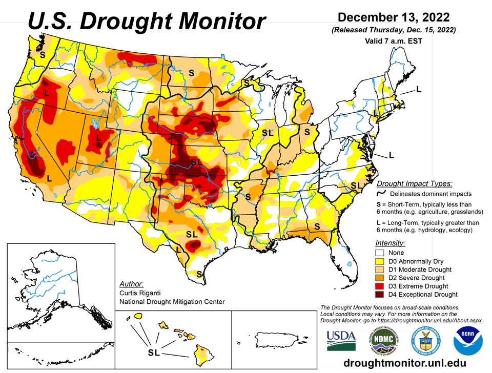
December 15, 2022 - While much of the contiguous U.S. is still experiencing drought or abnormal dryness, several storm systems dropped large amounts of precipitation over the past week in the form of rain or snow, especially in California and from eastern Oklahoma through Tennessee. Since some of this precipitation fell near the Tuesday morning data cutoff, more analysis of the early week precipitation will be performed next week, when more data is available to analyze changes to ongoing drought conditions. In parts of the Great Lakes, Southeast, and northwest Kansas that missed out on recent precipitation, drought or abnormal dryness developed or worsened.
Northeast
Widespread moderate precipitation fell in the Northeast this week, and localized long-term drought and abnormal dryness mostly persisted. Recent precipitation in northwest Massachusetts reduced precipitation deficits and increased streamflows enough to end ongoing long-term moderate drought there. Temperatures in the region were mostly within 5 degrees of normal for the week.
Southeast
Changes to drought conditions varied across the region, with much of northern Georgia and Alabama seeing improvement, while southern Georgia, the eastern Carolinas, southeast Alabama, parts of northern Florida, and northern Virginia and adjacent Maryland saw conditions worsen. Widespread moderate to heavy rain, and associated improvements to streamflows, soil moisture, and precipitation deficits, mostly led to improvements to conditions in northern Georgia, northern Alabama, and far western South Carolina and North Carolina. Degradations in the eastern portions of the Carolinas, southern Georgia, and southeast Alabama and adjacent Florida occurred in areas that mostly missed out on heavier precipitation, and therefore saw worsening soil moisture, streamflow, and mostly short-term precipitation deficits. Most of the region saw warmer-than-normal temperatures this week, with parts of Alabama reaching at least 15 degrees above normal.
South
In northern parts of the region, from central and eastern Oklahoma eastward through Tennessee, widespread moderate to heavy rain fell, leading to widespread improvements to ongoing drought and abnormal dryness. In central Oklahoma and north Texas, given that some of this rain fell near the data cutoff, more changes may be made next week as more data becomes available. Wetter recent weather led to improvements in surface conditions and precipitation deficits in central and west-central Texas, leading to some improvements in ongoing drought there. Due to recent heavy rainfall, severe drought areas in southwest Arkansas and near the Louisiana/Mississippi border were removed. A few localized spots in the eastern half of Texas saw conditions worsen after missing out on recent rains. Most of the region saw above-normal temperatures this week, with large portions of central and eastern Texas, Louisiana, and Mississippi seeing readings at least 15 degrees above normal.
Midwest
Conditions varied widely across the Midwest region this week. Short-term dryness continued in parts of Indiana, Ohio, and Illinois, where recent precipitation mostly missed to the south and west before Tuesday morning. Severe short-term drought developed in southeastern parts of the Michigan Lower Peninsula, where soil moisture and precipitation deficits mounted, and reports of groundwater problems emerged. Meanwhile, in the southern tier of the region, from southern Missouri eastward through Kentucky, widespread moderate to heavy rain led to widespread improvements to ongoing drought and abnormal dryness, with most of southwest Missouri and almost all of Kentucky seeing a one-category improvement to conditions. An early-week storm system deposited both rain and frozen precipitation in Iowa and other parts of the Upper Midwest near the Tuesday morning data cutoff. A small reduction in extreme drought coverage was made just northeast of Sioux City, Iowa, where higher amounts of precipitation fell. Across the rest of the region that experienced significant precipitation on Monday night and Tuesday, further analysis will occur next week. More improvements may be made next week if the wider suite of data is supportive when it becomes available.
High Plains
Heavier rains accumulated Monday night into early Tuesday in parts of southeast Kansas, leading to some improvements in the drought situation there as precipitation deficits lessened. Dry weather continued in parts of northwest Kansas, where soil moisture deficits and long-term precipitation deficits continued to worsen. A few small changes (one improvement and one degradation) were made in southeast Colorado and adjacent northeast New Mexico, where surface conditions changed in tandem with recent precipitation or lack thereof. Elsewhere, conditions did not change much across the region. Snow and rain that fell Monday night and Tuesday morning from northeast Colorado into Nebraska and southern South Dakota will be analyzed further next week for possible improvements to ongoing drought. Temperature anomalies for the week varied from north to south across the region, with below-normal temperatures occurring in most of North Dakota, while near- or slightly above-normal temperatures were more common in Colorado and Kansas.
West
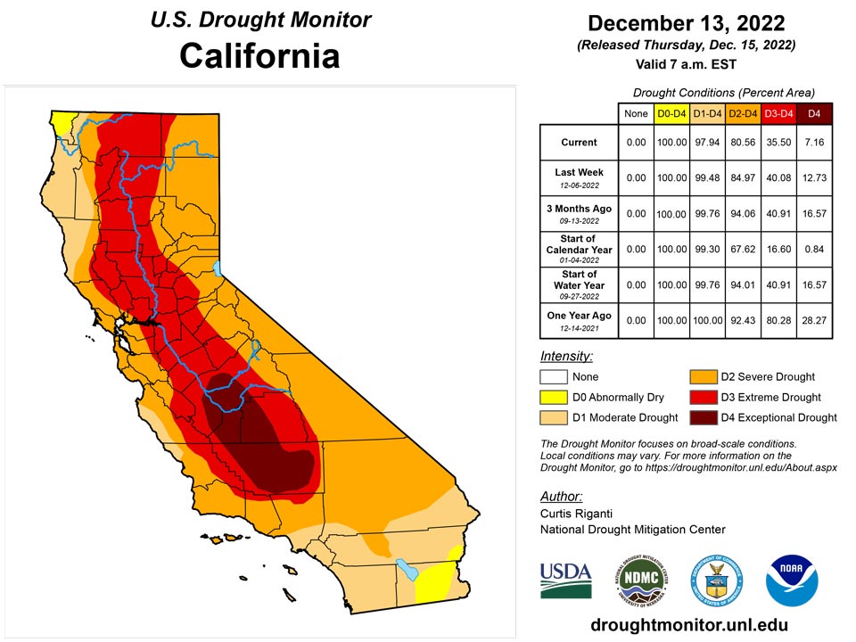
Widespread improvements to ongoing drought occurred across parts of the West region this week, due to copious amounts of rain or snow. Hefty rainfall amounts in some of the coastal mountain ranges of California caused high streamflow, which lessened precipitation deficits and led to localized improvements. Widespread improvements occurred in parts of the central Sierra Nevada range, where heavy snow fell and added to a healthy early-season snowpack. Recent rain and snow also improved conditions in parts of Arizona, Nevada, Utah, Idaho, southwest Montana, and near the Columbia River along the Arizona/Washington border. Despite recent precipitation, a small part of southwest Oregon saw abnormal dryness develop where precipitation and soil moisture deficits mounted. Temperatures across the West region were generally near or a bit below normal, with the exceptions of New Mexico and eastern Montana, which had above- and below-normal temperatures, respectively.
Caribbean
The weather has dried out a bit in parts of Puerto Rico over the last month, but longer-term wetness kept the entire area free of drought or abnormal dryness.
The U.S. Virgin Islands received plentiful rain during the fall, but have trended drier in recent weeks as this is the dry season. The National Weather Service’s 7-day quantitative precipitation estimates indicate that St. Thomas received 0.25 inches or less, St. John received 0.10 inches or less, while St. Croix received mostly 0.10 inches or less on the western end of the island and no rain on the eastern end. All islands remain drought-free.
Conditions have been sufficiently dry, however, to turn the Standardized Precipitation Index negative on the one-month time scale for St. Croix and St. Thomas. The value for St. Croix, in particular, was negative enough to indicate that abnormal dryness could be warranted, but in the absence of impacts, St. Croix can remain free of abnormal dryness on the USDM for another week. The SPI values at longer time scales remained wet or neutral for all islands.
The Vegetation Health Index does not yet indicate much stress for St. Croix, and local feedback does not yet indicate impacts. Wells depth of water level below the land surface benefited from the fall precipitation, but the distance from the land surface to the water level has begun to increase again for wells on all islands.
Pacific
Alaska remained free of drought or abnormal dryness this week. Temperatures in the northern half of the state were mostly well above normal, especially along the Arctic Coast, while near- or below-normal temperatures were more common in the southern half of Alaska.
Trade wind showers on the windward sides of Oahu and Kauai helped to halt a drying trend in these areas. Drought and abnormally dry conditions across the state did not change this week.
The Republic of Palau received ample rain with more than 4 inches at Palau and Koror. Water supplies should be brimming.
The Mariana Islands all had enough rain to be free of drought. Guam received 1.01 inches, while Rota reported 1.82 inches. Saipan received from 0.52 to 1.27 inches at the three reporting locations. These islands need an inch weekly to meet minimum water needs.
The Federal States of Micronesia were mixed with many locations receiving nearly two inches or more. Lukunor and Yap remained at D0 and received 1.27 and 2.51 inches, respectively. Several days of data were missing for Fananu, Pohnpei, and Kapingamarangi, which is at D2. Pingelap was set to No Data, due to missing data for the past two weeks. Kosrae received 3.41 inches, while Woleai reported 7.01 inches.
The Marshall Islands were mostly below 2 inches of precipitation for the week, but received enough rain recently that water supplies should be adequate. The Majuro reservoir held 26.879 million gallons on Dec. 6. Two weeks of improved rainfall for Wotje resulted in removal of D0. All locations were free of drought.
American Samoa remained free of dryness. Pago Pago, Siufaga Ridge and Toa Ridge received less than an inch of rain, which is the amount these islands need to meet minimum water needs, but have all gotten more than 2 inches since the start of December and ought to have enough water.
Looking Ahead
According to forecasts from the National Weather Service (NWS) Weather Prediction Center, as the weekend progresses into early next week, most areas east of the Rocky Mountains may expect near- or slightly below-normal temperatures. Meanwhile, a much-colder-than-normal airmass should build into the northern Great Plains. Widespread precipitation is forecast for the Great Lakes region through Monday evening, and from the southern Appalachians into the Northeast.
From December 20-28, the NWS Climate Prediction Center outlooks suggest that this cold airmass will spill into parts of the central and eastern U.S., where high confidence forecasts of below-normal temperatures exist. In parts of California and Nevada, forecasts lean toward above-normal temperatures during this period, especially from December 22-28. Precipitation forecasts lean toward above-normal precipitation for the Northern Rockies, Pacific Northwest, Northern Great Plains, and Northeast from December 20-28. Drier-than-normal weather is favored in the Desert Southwest, Southern Great Plains, and the Ohio and Tennessee River valleys. For Alaska, above-normal precipitation is favored in the southern part of the state, while below-normal precipitation is favored in the northern part of the state. The temperature forecasts vary more between the 6-10 and 8-14 day periods, but generally, below-normal temperatures are more likely in eastern Alaska, while the Aleutian Islands are more likely to see warmer-than-normal temperatures.
Author(s):
Curtis Riganti, National Drought Mitigation Center
Denise Gutzmer, National Drought Mitigation Center
Dryness Categories
D0 Abnormally Dry—used for areas showing dryness but not yet in drought, or for areas recovering from drought.
Drought Intensity Categories
D1 Moderate Drought
D2 Severe Drought
D3 Extreme Drought
D4 Exceptional Drought
Drought or Dryness Types
S Short-term, typically less than 6 months (agriculture, grasslands)
L Long-term, typically more than 6 months (hydrology, ecology)
SL Area contains both short- and long-term impacts
Source: National Drought Mitigation Center

