


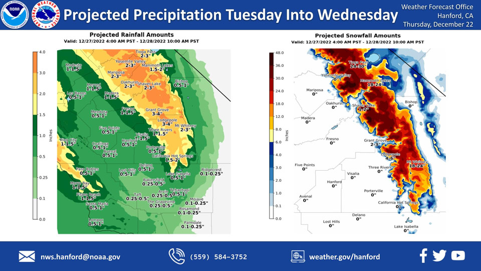
Mariposa, Tuesday/Wednesday Projected Precipitation: 2.00" to 3.00"
Oakhurst, Tuesday/Wednesday Projected Precipitation: 2.00" to 3.00"
Yosemite Valley, Tuesday/Wednesday Projected Precipitation: 2.00" to 3.00"
December 22, 2022 - The National Weather Service Hanford Office reports the next storm system will impact Central California Tuesday into Wednesday morning, resulting in a likelihood of snow in the higher elevations of the Sierra Nevada and rain in the San Joaquin Valley.
Snow levels will start at around 8,000 feet Tuesday, before dropping to about 7,000 feet Tuesday night.
Snow levels may drop to 6,000 feet Wednesday morning.
The majority of this precipitation will fall Tuesday afternoon and Tuesday evening.
Area Forecast Discussion
National Weather Service Hanford CA
200 AM PST Thu Dec 22 2022
.SYNOPSIS...A weak system will move to the north of our area
tonight and possibly bring a few showers to Yosemite Park. High
pressure will build over central California on Friday and remain
over the region through the holiday weekend. This will provide
for dry weather and above normal temperatures although locally
dense fog will remain a possibility in the San Joaquin Valley
each day through Monday. Widespread precipitation is expected
across the area on Tuesday as a strong storm moves into the area.
This will be followed by another storm on Wednesday night.
&&
.DISCUSSION...Satellite imagery indicating a low cloud deck
covering much of the San Joaquin Valley. Some thin high clouds are
streaming over aver the area being pushed inland ahead of an
upper level shortwave which is progged to track inland over Norcal
tonight. This system will bring some high clouds and a slight
chance of precipitation over the Yosemite Park area tonight. It
will also provide for some mixing to take place tonight and the
stratus deck over the San Joaquin Valley will most likely either
rise or dissipate by Friday morning. In the meantime, the stratus
deck over the San Joaquin Valley will likely persist well into
this afternoon or evening which places reduce confidence in the
temperature forecasts for the lower elevations for today.
SREF is indicating high pressure will build back into Cencal on
Friday and strengthen over our area on Saturday and Christmas Day.
This will result in dry conditions prevailing across the area
Friday through the holiday weekend. Temperatures are progged to be
well above seasonal normals although fog could lessen the warming
trend over the San Joaquin Valley as well as create hazardous
travel conditions in the valley during the holiday weekend.
Ensemble means are showing a change in the pattern taking place
by early next week as the high breaks down and a zonal flow
pattern becomes established over the EPAC and western CONUS. This
will open the door for a series of storms to impact the western
CONUS as an atmospheric river takes aim at Norcal and brings
significant precipitation further south to our area at times. The
first of these systems is expected to impact our area next Tuesday
with the latest NBM probabilistic guidance indicating that areas
north of Kern County have between a 70 and 90 percent chance of
measurable precipitation. The Tuesday storm is also progged to be
warm with snow levels expected to be at 8000 feet or higher.
Although the major passes will likely not be impacted by winter
weather, there is a concern of rain over existing snowpack which
could produce increased runoff and flooding in the Sierra Nevada
and adjacent foothills. This storm is expected to be followed by
another storm next Wednesday night and Thursday.
&&
.AVIATION...Areas of IFR cigs and visibility the San Joaquin
Valley in low clouds and mist. Otherwise, VFR conditions will
prevail across the central CA interior for the next 24 hours.
&&
.AIR QUALITY ISSUES...On Thursday December 22 2022, Unhealthy
for Sensitive Groups in Fresno, Kern, and Kings Counties.
Fireplace/Wood Stove Burning Status is: No Burning For All in
Fresno and Kern Counties. No Burning Unless Registered in Kings,
Madera, Merced, and Tulare Counties. Burning Discouraged in Kern
(Greater Frazier Park Area) and Sequoia National Park and Forest.
&&
.CERTAINTY...
The level of certainty for days 1 and 2 is medium.
The level of certainty for days 3 through 7 is medium.
Certainty levels include low...medium...and high. Please visit
www.weather.gov/hnx/certainty.html for additional information
and/or to provide feedback.
&&
.HNX WATCHES/WARNINGS/ADVISORIES...None.
Source: NWS

