


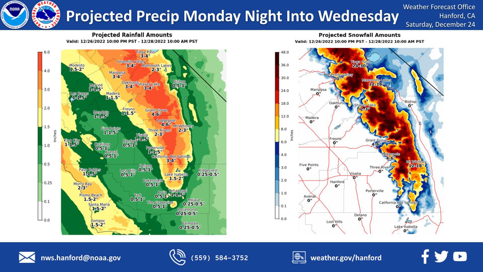
Mariposa, Monday Night/Tuesday/Wednesday Projected Precipitation: 2.00" to 3.00" Updated: 3.00" to 4.00"
Oakhurst, MondayNIght/Tuesday/Wednesday Projected Precipitation: 2.00" to 3.00" Updated: 3.00" to 4.00"
Yosemite Valley, MonayNight/Tuesday/Wednesday Projected Precipitation: 2.00" to 3.00" Updated: 3.00" to 4.00"
December 24, 2022 - The National Weather Service Hanford Office reports the next storm system will impact Central California Monday night through Wednesday morning, resulting in high elevation snow in the Sierra Nevada and rain in the San Joaquin Valley.
Snow levels will start at around 8,000 feet Tuesday, before dropping to about 7,000 feet Tuesday night. Snow levels will drop to 6,000 feet Wednesday morning.
The majority of this precipitation will fall Tuesday.
Area Forecast Discussion
National Weather Service Hanford CA
316 AM PST Sat Dec 24 2022
.SYNOPSIS...
Patchy dense fog will persist in the San Joaquin Valley each night
and morning through the weekend. The next storm system will impact
Central California Tuesday into Wednesday, resulting in a likelihood
of high elevation snow in the Sierra Nevada and rain in the San
Joaquin Valley. Another storm system will bring additional
precipitation chances for the latter part of next week.
&&
.DISCUSSION...
Dense fog again blankets much of the San Joaquin Valley this
morning beneath a ridge of high pressure over the region, while
overnight temperatures continue to run a bit below normal.
Ensemble model solutions strengthen the ridge over the area
through Sunday, and fog will likely occur yet again overnight
tonight. Persistent fog and stratus in the San Joaquin Valley have
been holding afternoon high temperatures there several degrees
below normal values during the last few days. This scenario is
likely to repeat today and Sunday for areas that clear out late or
not at all. Blended model guidance has thus far not handled this
pattern well and shows around a 10 percent probability for high
temperatures below 52 degrees in the San Joaquin Valley today and
on Sunday. Our forecast for Valley high temperatures today and
Sunday continues to run in the lower probability range of
outcomes, several degrees below normal.
Ensembles begin to weaken and displace the ridge on Monday as a
low pressure system approaches the Pacific Northwest region and
then begins to push inland Tuesday. This is expected to help clear
out the San Joaquin Valley Monday allowing afternoon high
temperatures to push a bit above normal readings. The low pressure
system will also steer a moisture plume across central
California, with precipitable water values of 1 to 1.25 inches, or
3 to 4 standard deviations above normal, likely by early Tuesday.
With this anomalous moisture surge into the area, significant
snowfall accumulations will occur in the higher elevations of the
Sierra Nevada Tuesday into Wednesday. Snow levels will start out
above 8000 feet in this flow, lowering to around 7000 feet Tuesday
night and 5-6 thousand feet by Wednesday. Total snowfall
accumulations will be around 3-4 feet in the higher Sierra
elevations.
Below the snow level, rainfall amounts will also be significant,
around 1/2 to 3/4 of an inch on the west side of the San Joaquin
Valley and up to 1.5 inches farther east, with 2-4 inches up into
the adjacent foothills. 1/3 to 1/2 inch of rainfall is forecast
for the desert areas. Behind this system, ensembles bring a less
anomalous stream of moisture over central California, producing a
smaller amount of rain and mountain snow Thursday into Friday.
Temperatures are forecast around normal values during the second
half of next week.
&&
.AVIATION...
Areas of IFR and local LIFR conditions due to fog and low stratus are
likely in the San Joaquin Valley through 20Z Saturday and again
after 09z Sunday. VFR conditions are otherwise expected across the
central California interior for at least the next 24 hours.
&&
.AIR QUALITY ISSUES...
On Saturday December 24 2022, Unhealthy for Sensitive Groups in
Fresno, Kern, Kings, Madera, Merced, and Tulare Counties.
Fireplace/Wood Stove Burning Status is: No Burning For All in
Fresno, Kern, and Madera Counties. No Burning Unless Registered in
Kings, Merced, and Tulare Counties. Burning Discouraged in Kern
(Greater Frazier Park Area) and Sequoia National Park and Forest.
&&
.CERTAINTY...
The level of certainty for days 1 and 2 is medium.
The level of certainty for days 3 through 7 is medium.
Certainty levels include low...medium...and high. Please visit
www.weather.gov/hnx/certainty.html for additional information
and/or to provide feedback.
&&
.HNX WATCHES/WARNINGS/ADVISORIES...
Dense Fog Advisory until noon PST Saturday for CAZ301>303-
305>307-309>312-314>316.
Source: NWS

