


Now Upgraded to a Winter Storm Warning
Winter Storm Warning Issued for the Sierra Nevada Above 6,000 Feet Beginning Monday Evening – Includes Yosemite (Outside of the Valley) to Lodgepole
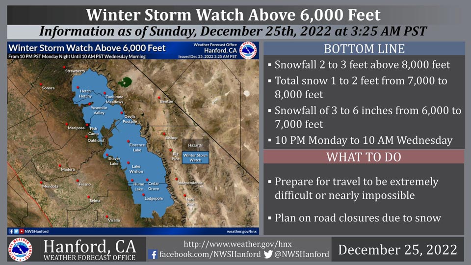
December 25, 2022 - The National Weather Service Hanford Office reports a Winter Storm Watch is in effect for the Sierra Nevada above 6,000 feet from 10:00 P.M. Monday night until 10:00 A.M. Wednesday morning.
A Winter Storm Watch means there is potential for significant snow accumulations that may impact travel.
The majority of this snow will fall Tuesday.
Winds may gust as high as 55 mph on exposed ridgetops and near the crest.
Travel could be extremely difficult or impossible. If you plan to travel, consider alternate strategies. If you must travel, remember to carry tire chains, plenty of food, a good deal of water, warm clothing, and a flashlight in your vehicle.
Winter Storm Watch
URGENT - WINTER WEATHER MESSAGE
National Weather Service Hanford CA
343 AM PST Sun Dec 25 2022

Yosemite NP outside of the valley-Upper San Joaquin River-
Kaiser to Rodgers Ridge-Kings Canyon NP-Grant Grove Area-
Sequoia NP-
Including the cities of Tuolumne Meadows, Wawona,
Devils Postpile, Florence Lake, Lake Thomas Edison, Lake Wishon,
Huntington Lake, Shaver Lake, Cedar Grove, Grant Grove,
Hume Lake, Giant Forest, and Lodgepole
343 AM PST Sun Dec 25 2022

...A WINTER STORM WATCH REMAINS IN EFFECT FROM MONDAY EVENING
THROUGH WEDNESDAY MORNING ABOVE 6,000 FEET...

* WHAT...Heavy snow possible above 6,000 feet. Total snow
  accumulations of two to three feet conceivable above 8,000 feet.
  Total snow amounts of one to two feet possible from 7,000 feet
  to 8,000 feet. Total snow accumulations of three to six inches
  conceivable from 6,000 feet to 7,000 feet. Winds may gust as
  high as 55 mph on exposed ridgetops and along the crest.

* WHERE...Sierra Nevada from Yosemite National Park to Sequoia
  National Park.

* WHEN...From Monday evening through Wednesday morning.

* IMPACTS...Travel could be extremely difficult or nearly
  impossible. Plan on road closures due to snow cover. Strong wind
  gusts could cause extensive tree damage. Snow load may cause
  roof damage.

PRECAUTIONARY/PREPAREDNESS ACTIONS...

If you plan to travel, consider alternate strategies. If you must
travel, remember to carry tire chains, plenty of food, a good deal
of water, warm clothing, and a flashlight in your vehicle.

Monitor the latest forecasts for updates on this situation.
Source: NWS

