


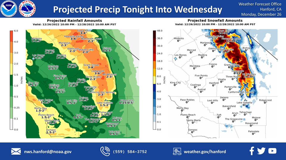
Mariposa, Monday Night/Tuesday/Wednesday Projected Precipitation: Reduced to 2.00" to 3.00" from 3.00" to 4.00"
Oakhurst, MondayNIght/Tuesday/Wednesday Projected Precipitation: Reduced to 2.00" to 3.00" from 3.00" to 4.00"
Yosemite Valley, MondayNight/Tuesday/Wednesday Projected Precipitation: 3.00" to 4.00"
December 26, 2022 - The National Weather Service Hanford Office reports the next storm system will impact Central California tonight through Wednesday morning, resulting in high elevation snow in the Sierra Nevada and rain in the San Joaquin Valley.
Snow levels will start at around 8,000 feet Tuesday, before dropping to about 7,000 feet Tuesday night. Snow levels will drop to 6,000 feet Wednesday morning.
The majority of this precipitation will fall Tuesday.
Area Forecast Discussion
National Weather Service Hanford CA
1255 AM PST Mon Dec 26 2022
.SYNOPSIS...
Widespread, dense fog will remain draped over the San Joaquin
Valley this morning. Precipitation ahead of the next storm system
will overspread Central California late tonight into Tuesday
morning. The majority of precipitation associated with this storm
system will fall Tuesday afternoon and Tuesday evening. Periodic
precipitation is expected the remainder of the week.
&&
.DISCUSSION...
Widespread, dense fog in the San Joaquin Valley is reducing
visibilities to one quarter of a miles or less. A Dense Fog
Advisory is in effect for the San Joaquin Valley until 11 AM PST
this morning. A trough of low pressure will move eastward this
afternoon and tonight. Precipitation ahead of this trough of low
pressure will overspread Central California late tonight into
Tuesday morning. Most precipitation associated with this storm
system will fall Tuesday afternoon and Tuesday evening as an
atmospheric river moves southward through Central California.
Southeast to south wind gusts near 35 mph are possible in the
northwestern portion of the San Joaquin Valley and Coastal Range
Tuesday. A Wind Advisory may be required.
A Winter Storm Warning is in effect for the Sierra Nevada above
6,000 feet from 10 PM PST tonight until 10 AM PST Wednesday
morning. Two to three feet of snow is expected above 8,000 feet.
One to two feet of snow is anticipated from 7,000 feet to 8,000
feet. Four to eight inches of snow is expected from 6,000 feet to
7,000 feet. The snow level will start at around 8,000 feet
tonight, before falling to about 7,000 feet Tuesday night. The
snow level will drop to around 6,000 feet Wednesday morning. Major
to extreme winter storm impact are expected above 7,000 feet
Tuesday and Tuesday night due to snow load. Winds will gust as
high as 55 mph on exposed ridgetops and along the crest. These
strong, gusty winds may cause significant tree damage.
One half of an inch to one inch of rain is possible in the western
portion of the San Joaquin Valley tonight through Wednesday
morning. One inch to one and one half of an inch or rain is
conceivable in the central portion of the San Joaquin Valley
tonight through Wednesday night. One and one half of an inch to
two inches of rain is possible in the eastern portion of the San
Joaquin Valley tonight through Wednesday morning. This rainfall
could lead to nuisance flooding, especially Tuesday afternoon and
Tuesday evening when rain rates will be highest. One to two inches
of rain is conceivable in the Kern County mountains Tuesday
through Wednesday morning. Two to four inches of rain is possible
in the Sierra Nevada foothills tonight through Wednesday morning.
Three to four inches of rain is conceivable in the Sierra Nevada
below 6,000 feet tonight through Wednesday morning. This rainfall
could result in rockslides in canyons and steep hillsides,
particularly Tuesday afternoon and Tuesday evening when rain rates
will be highest.
A series of storm systems will impact Central California from the
middle to the week into the upcoming weekend, producing periodic
precipitation. The strongest in this series of storm systems looks
to take place Friday night and Saturday as another atmospheric
river could move over Central California.
&&
.AVIATION...
LIFR conditions are likely in the San Joaqin Valley this morning
due to dense fog. IFR ceilings are expected to persist in the San
Joaquin Valley this afternoon. IFR conditions and mountain
obscurations are anticipated in the Sierra Nevada Monday night
as precipitation overspreads Central California from north to
south. MVFR or lower conditions are possible in the San Joaquin
Valley late Monday night in and near showers.
&&
.AIR QUALITY ISSUES...
On Monday, December 26th, 2022, unhealthy for sensitive groups in
Fresno and Kern Counties. Fireplace/wood stove burning status is:
no burning for all in Fresno and Kern Counties. No burning unless
registered in Kings, Madera, Merced, and Tulare Counties. Burning
discouraged in Kern (Greater Frazier Park Area) and Sequoia
National Park and Forest.
&&
.CERTAINTY...
The level of certainty for days 1 and 2 is high.
The level of certainty for days 3 through 7 is medium.
Certainty levels include low, medium, and high. Please visit
www.weather.gov/hnx/certainty.html for additional information
and/or to provide feedback.
&&
.HNX WATCHES/WARNINGS/ADVISORIES...
Dense Fog Advisory until 11 AM PST this morning for CAZ301>303-
305>307-309>312-314>316.
Winter Storm Warning from 10 PM this evening to 10 AM PST
Wednesday for CAZ323-326>330.
Source: NWS

