


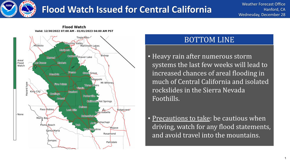
December 28, 2022 - The National Weather Service Hanford Office reports heavy rain after numerous storm systems the last few weeks will lead to increased chances of areal flooding in much of Central California and isolated rockslides in the Sierra Nevada Foothills.
Precautions to take include: be cautious when driving, watch for any flood statements, and avoid travel into the mountains.
Flood Watch
Flood Watch
National Weather Service Hanford CA
935 AM PST Wed Dec 28 2022

.Parade of atmospheric rivers has made soil conditions more
favorable for flooding across the entire San Joaquin Valley, Coastal
Range, and Sierra Nevada Foothills. A strong storm system is
forecast to bring hydrological impacts to the region Friday through
Sunday morning, so a Flood Watch has been issued.


West Side Mountains north of 198-Los Banos - Dos Palos-Merced -
Madera - Mendota-Planada - Le Grand - Snelling-Coalinga - Avenal-
West Side of Fresno and Kings Counties-Caruthers - San Joaquin -
Selma-Fresno-Clovis-West Side Mountains South of 198-Buttonwillow -
Lost Hills - I5-Delano-Wasco-Shafter-Hanford - Corcoran - Lemoore-
Visalia - Porterville - Reedley-Buena Vista-Bakersfield-Southeast
San Joaquin Valley-South End San Joaquin Valley-Mariposa Madera
Foothills-Mariposa-Madera Lower Sierra-Fresno-Tulare Foothills-
Fresno-Tulare Lower Sierra-South End Sierra Foothills-South End of
the Lower Sierra-
Including the cities of Bakersfield, Lake Mcclure, Kettleman City,
Blackwells Corner, Tulare, Lost Hills, Buttonwillow, Kingsburg,
Fresno, Shafter, Coalinga, Hanford, Bass Lake, Five Points, Goshen,
Auberry, Richgrove, Lemoore Station, North Fork, Atwater,
McKittrick, El Portal, Los Banos, Corcoran, San Luis Reservoir,
Arvin, Mariposa, Planada, Selma, Parlier, Alpaugh, Fish Camp,
Lamont, Avenal, Sanger, Delano, Camp Nelson, Millerton Lake, Le
Grand, Wasco, Visalia, Madera, Kerman, Oakhurst, Porterville,
Merced, Lemoore, Taft, and Coarsegold
935 AM PST Wed Dec 28 2022

...FLOOD WATCH IN EFFECT FROM FRIDAY MORNING THROUGH LATE SATURDAY
NIGHT...

* WHAT...Flooding caused by excessive rainfall is possible.

* WHERE...A portion of central California, including the following
  areas, Bakersfield, Buena Vista, Buttonwillow - Lost Hills - I5,
  Caruthers - San Joaquin - Selma, Coalinga - Avenal,
  Delano-Wasco-Shafter, Fresno-Clovis, Fresno-Tulare Foothills,
  Fresno-Tulare Lower Sierra, Hanford - Corcoran - Lemoore, Los
  Banos - Dos Palos, Mariposa Madera Foothills, Mariposa-Madera
  Lower Sierra, Merced - Madera - Mendota, Planada - Le Grand -
  Snelling, South End San Joaquin Valley, South End Sierra
  Foothills, South End of the Lower Sierra, Southeast San Joaquin
  Valley, Visalia - Porterville - Reedley, West Side Mountains South
  of 198, West Side Mountains north of 198 and West Side of Fresno
  and Kings Counties.

* WHEN...From Friday morning through late Saturday night.

* IMPACTS...Excessive runoff may result in flooding of rivers,
  creeks, streams, and other low-lying and flood-prone locations.
  Creeks and streams may rise out of their banks. Flooding may occur
  in poor drainage and urban areas. Low-water crossings may be
  flooded. Storm drains and ditches may become clogged with debris.
  Extensive street flooding and flooding of creeks and rivers are
  possible. Area creeks and streams are running high and could flood
  with more heavy rain. Rockslides in steep canyons will be possible
  in the Sierra Nevada and foothills.

* ADDITIONAL DETAILS...
  - Parade of atmospheric rivers has lead to wet soils leading to
    higher probabilities of flooding across the entire San
    Joaquin Valley, Coastal Range, and the Sierra Nevada
    Foothills. Flooding and rockslides were observed with the
    last system, and may occur again with this next storms. Area
    rivers are forecast to rise, and may lead to flooding.
  - http://www.weather.gov/safety/flood

PRECAUTIONARY/PREPAREDNESS ACTIONS...

You should monitor later forecasts and be alert for possible Flood
Warnings. Those living in areas prone to flooding should be prepared
to take action should flooding develop.
Source: NWS

