


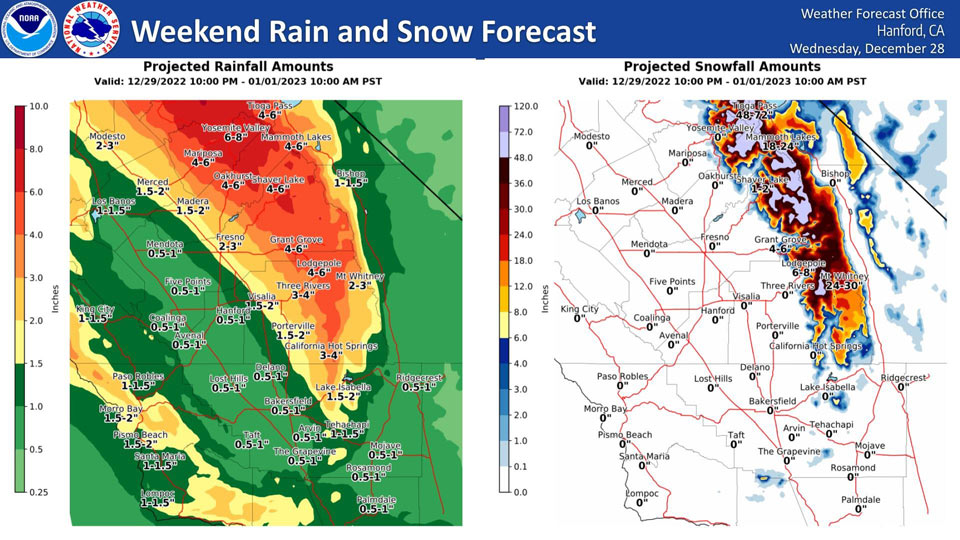
Mariposa, Thursday to Sunday Projected Precipitation: 4.00" to 6.00"
Oakhurst, Thursday to Sunday Projected Precipitation: 4.00" to 6.00"
Yosemite Valley, Thursday to Sunday Projected Precipitation: 6.00" to 8.00"
December 29, 2022 - The National Weather Service Hanford Office reports the rain and snow forecast totals for this weekend's major event.
Area Forecast Discussion
National Weather Service Hanford CA
307 AM PST Thu Dec 29 2022
.SYNOPSIS...
Break in the active weather pattern occurred on Wednesday before
a weak disturbance brings light precip to the region this morning.
A larger and stronger storm system will bring additional heavy
rain and mountain snow across the region Friday through early
Sunday. Active weather pattern may continue into next week.
&&
.DISCUSSION...
Wednesday saw a brief break in the weather across Central
California as fog quickly returned to the San Joaquin Valley. The
brief break is rapidly ending as precipitation rolls back into the
area. While the current fetch of moisture pushing into California
is not a plume associated with an Atmospheric River (AR), light
to possible moderate precipitation will received over the district
this Thursday. Yet, the magnitude of how much precipitation will
be received is well below the threshold needed for any warnings or
advisories. However, the light precipitation expected will be
beneficial as snow levels near 4000 feet will provide the
mountains will extra snowfall. In addition, the passage of the
current disturbance is helping keep the area from fogging-up as
much of the valley is showing visibility values between 5 and 10
miles. Furthermore, due to the weakness of the disturbance, will
not expect winds to blow until the next Atmospheric River enters
the area on Friday. A return to excessive precipitation will begin
affecting Central California on Friday as heavy rain and snow
will impact Central California by the end of the week.
High Resolution ensemble analysis showing the end of the dry
pattern this morning as ensembles have a good handle on the light
precipitation. While unsettled conditions will be seen today, the
district still has well over 18 hours before the next significant
storm enters the district. Based on ensemble precip-water values
pushing into Central California, will expect the light
precipitation progged for this Thursday. Looking beyond Thursday
and into Friday, ensembles show the higher concentration of
moisture shifting toward California. Therefore, with a similar
setup to the previous AR of earlier this week, significant
precipitation will once again impact the area. Ensembles are
showing increased confidence that the next plume of moisture to
strike the area may approach Moderate Atmospheric River (AR)
magnitude based on Integrated Vapor Transport analysis. Moderate
AR magnitude could possibly be reached on Saturday before dropping
back to weak AR ranges on Sunday/Monday. With minimal change in
the jet stream for much of the weekend period, additional pieces
of energy will cross the area and allow for a continuation of
precipitation into the early part of next week.
Long range ensemble keep the ridge pattern at bay during the 3 to
7 day period. With Ensemble Cluster Analysis maintaining a good
signal toward an unsettled pattern, will keep the possibility of
precipitation going through at least next Wednesday. Yet, a longer
period of dry weather may exist between the early part of next
week and next Wednesday. Will welcome the moisture expected during
the next seven days.
&&
.AVIATION...VFR/MVFR conditions should prevail across the Central
California Interior. Occasional IFR over the higher terrain in
showers during the next 24 hours.
&&
.AIR QUALITY ISSUES...
On Thursday December 29 2022,Fireplace/Wood Stove Burning Status
is: No Burning Unless Registered in Fresno and Kern Counties.
Burning Discouraged in Kings, Madera, Merced, and Tulare Counties,
and Kern (Greater Frazier Park Area) and Sequoia National Park
and Forest.
&&
.CERTAINTY...
The level of certainty for days 1 and 2 is high.
The level of certainty for days 3 through 7 is medium.
Certainty levels include low...medium...and high. Please visit
www.weather.gov/hnx/certainty.html for additional information
and/or to provide feedback.
&&
.HNX WATCHES/WARNINGS/ADVISORIES...
Flood Watch from Friday morning through late Saturday night for
CAZ300>322-324-325.
Winter Storm Watch from this evening through late Saturday night
for CAZ323-326>331.
Source: NWS

