


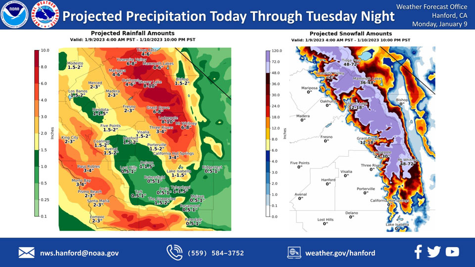
Mariposa, Monday through Tuesday Night Projected Precipitation: 4.00" to 6.00"
Oakhurst, Monday through Tuesday Night Projected Precipitation: 4.00" to 6.00"
Yosemite Valley, Monday through Tuesday Night Projected Precipitation: 6.00" to 8.00"
January 9, 2023 - The National Weather Service Hanford Office reports a strong storm system will impact Central California today through Tuesday night.
High confidence exists that environmental conditions will become favorable for heavy rainfall, resulting in flash flooding in the Sierra Nevada below the snow line and Sierra Nevada foothills today.
Area Forecast Discussion
National Weather Service Hanford CA
1249 AM PST Mon Jan 9 2023
.SYNOPSIS...A strong storm system will continue through Tuesday,
bringing periods of moderate to heavy rain and high elevation snow
along with gusty winds, especially on Monday. Dry weather is
likely on Wednesday and Thursday but dense fog may return to the
San Joaquin Valley. Another storm system is possible by the end of
the week for more wet weather.
&&
.DISCUSSION...A very strong atmospheric river will continue to
impact central California this morning and into the afternoon
hours. Satellite imagery this morning shows a very pronounced
fetch of moisture stretching all the way to 140W. Periods of
moderate to heavy rains will be likely through the morning and
afternoon hours with heavy amounts of high elevation snow above
8,000 feet. Central Valley residents can expect to see upwards of
1 to 3 inches of rainfall for this event with heavier amounts
expected further north and a general decrease in accumulations as
you head further southward into Bakersfield. Flooding will be a
primary concern for poor drainage areas through cities as well as
mudslides/rockslides for higher elevations. Use extreme caution if
you need to be out on the roadways today. Snowfall will be near 2
to 8 feet for lower mountain elevations with upwards of 10 to 12
feet possible for elevations above 8,000 feet.
Excessive rainfall may result in flooding of rivers, creeks,
streams, and other low-lying and flood-prone locations today. Bear
Creek at McKee Road in Merced County continues to show high
probabilities for exceeding flood stage by this evening.
Model ensembles favor dry conditions on Wednesday and Thursday with
a ridge over the west. But the moist soil conditions may allow for
dense fog development across the San Joaquin Valley again. Yet
another storm system is possible by the end of the week and into
next weekend.
&&
.AVIATION...In the San Joaquin Valley, West Side Hills and Sierra
foothills, areas of MVFR and local IFR conditions in low clouds
and rain after 06Z. In the Sierra Nevada and Tehachapi Mountains,
areas of mountain obscuring IFR conditions in low clouds and
precipitation after 12Z becoming widespread after 18Z. Otherwise,
VFR conditions will prevail for the next 24 hours.
&&
.AIR QUALITY ISSUES...
ISSUED: 01/08/2023 14:38
EXPIRES: 01/09/2023 23:59
On Monday January 9 2023,Fireplace/Wood Stove Burning Status is:
Burning Discouraged in Fresno, Kern, Kings, Madera, Merced, and
Tulare Counties, and Kern (Greater Frazier Park Area) and Sequoia
National Park and Forest.
&&
.CERTAINTY...
The level of certainty for days 1 and 2 is high.
The level of certainty for days 3 through 7 is medium.
Certainty levels include low...medium...and high. Please visit
www.weather.gov/hnx/certainty.html for additional information
and/or to provide feedback.
&&
.HNX WATCHES/WARNINGS/ADVISORIES...
Flood Watch through late Tuesday night for CAZ300>325-327-
329>336-338.
High Wind Warning until 4 PM PST this afternoon for CAZ300.
Wind Advisory until 4 PM PST this afternoon for CAZ301>307-
309>312-314>317-319-321-322-332>334.
High Wind Warning until 10 PM PST this evening for CAZ308-313-
335-336.
Winter Storm Warning until 4 AM PST Wednesday for CAZ323-326>330.
Source: NWS

