


Includes Mariposa , Madera Counties and Yosemite National Park
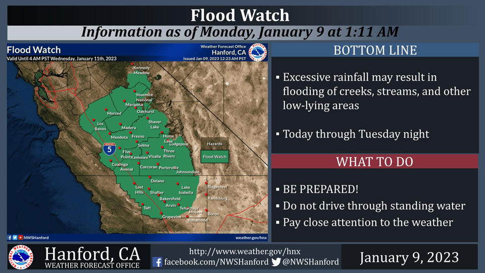
January 9, 2023 - The National Weather Service Hanford Office reports a high confidence exists that environmental conditions will become favorable for heavy rainfall, resulting in flash flooding in the Sierra Nevada below the snow line and Sierra Nevada foothills today.
Pay close attention to the weather and be ready to move to higher ground quickly.
Flood Watch
Flood Watch
National Weather Service Hanford CA
857 PM PST Sun Jan 8 2023


West Side Mountains north of 198-Los Banos - Dos Palos-Merced -
Madera - Mendota-Planada - Le Grand - Snelling-Coalinga - Avenal-
West Side of Fresno and Kings Counties-Caruthers - San Joaquin -
Selma-Fresno-Clovis-West Side Mountains South of 198-Buttonwillow -
Lost Hills - I5-Delano-Wasco-Shafter-Hanford - Corcoran - Lemoore-
Visalia - Porterville - Reedley-Buena Vista-Bakersfield-Southeast
San Joaquin Valley-South End San Joaquin Valley-Mariposa Madera
Foothills-Mariposa-Madera Lower Sierra-Fresno-Tulare Foothills-
Fresno-Tulare Lower Sierra-South End Sierra Foothills-South End of
the Lower Sierra-Yosemite NP outside of the valley-Yosemite Valley-
San Joaquin River Canyon-Kaiser to Rodgers Ridge-Grant Grove Area-
Sequoia NP-South End of the Upper Sierra-Kern River Valley-Piute
Walker Basin-Tehachapi-Grapevine-Frazier Mountain Communities-Mojave
Desert Slopes-
Including the cities of Coalinga, Sanger, Lake Mcclure, Visalia,
Lamont, Coarsegold, Buttonwillow, Oakhurst, Tuolumne Meadows,
Corcoran, Hanford, Kerman, Five Points, Fish Camp, Lake Isabella,
Giant Forest, Lemoore Station, Frazier Park, Arvin, Wasco, Tulare,
Kingsburg, McKittrick, Richgrove, San Luis Reservoir, Wawona,
Mojave, Grant Grove, Mariposa, Delano, Los Banos, Shaver Lake,
Huntington Lake, Planada, El Portal, Tehachapi, Lemoore, Le Grand,
Hume Lake, Lebec, Goshen, Madera, Bass Lake, North Fork, Alpaugh,
Bakersfield, Shafter, Kettleman City, Selma, Parlier, Taft,
Millerton Lake, Fresno, Atwater, Yosemite Valley, Grapevine,
Lodgepole, Merced, Auberry, Johnsondale, Blackwells Corner, Avenal,
Lake Wishon, Lost Hills, Camp Nelson, Porterville, and Kernville
857 PM PST Sun Jan 8 2023

...FLOOD WATCH REMAINS IN EFFECT THROUGH LATE TUESDAY NIGHT...

* WHAT...Flooding caused by excessive rainfall continues to be
  possible.

* WHERE...A portion of central California, including the following
  areas, Bakersfield, Buena Vista, Buttonwillow - Lost Hills - I5,
  Caruthers - San Joaquin - Selma, Coalinga - Avenal,
  Delano-Wasco-Shafter, Frazier Mountain Communities, Fresno-Clovis,
  Fresno-Tulare Foothills, Fresno-Tulare Lower Sierra, Grant Grove
  Area, Grapevine, Hanford - Corcoran - Lemoore, Kaiser to Rodgers
  Ridge, Kern River Valley, Los Banos - Dos Palos, Mariposa Madera
  Foothills, Mariposa-Madera Lower Sierra, Merced - Madera -
  Mendota, Mojave Desert Slopes, Piute Walker Basin, Planada - Le
  Grand - Snelling, San Joaquin River Canyon, Sequoia NP, South End
  San Joaquin Valley, South End Sierra Foothills, South End of the
  Lower Sierra, South End of the Upper Sierra, Southeast San Joaquin
  Valley, Tehachapi, Visalia - Porterville - Reedley, West Side
  Mountains South of 198, West Side Mountains north of 198, West
  Side of Fresno and Kings Counties, Yosemite NP outside of the
  valley and Yosemite Valley.

* WHEN...Through late Tuesday night.

* IMPACTS...Excessive runoff may result in flooding of rivers,
  creeks, streams, and other low-lying and flood-prone locations.
  Creeks and streams may rise out of their banks. Flooding may occur
  in poor drainage and urban areas. Low-water crossings may be
  flooded. Storm drains and ditches may become clogged with debris.
  Extensive street flooding and flooding of creeks and rivers are
  possible. Area creeks and streams are running high and could flood
  with more heavy rain.

* ADDITIONAL DETAILS...
  - http://www.weather.gov/safety/flood

PRECAUTIONARY/PREPAREDNESS ACTIONS...

You should monitor later forecasts and be alert for possible Flood
Warnings. Those living in areas prone to flooding should be prepared
to take action should flooding develop.
Source: NWS

