


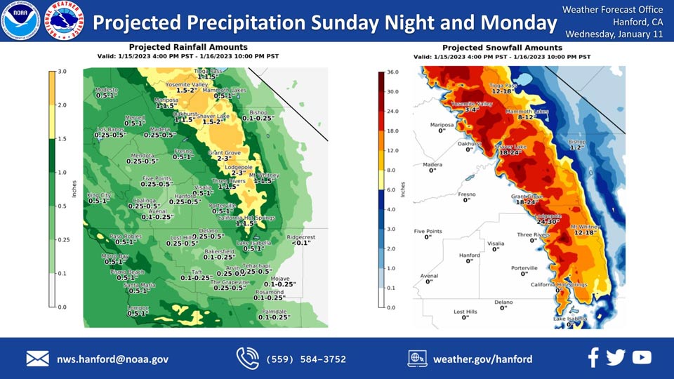
Mariposa, Sunday Night through Monday Projected Precipitation: 1.00" to 1.50"
Oakhurst, Sunday Night through Monday Projected Precipitation: 1.00" to 1.50"
Yosemite Valley, Sunday Night through Monday Projected Precipitation: 1.50" to 2.00"
January 11, 2023 - The National Weather Service Hanford Office reports another storm system will impact Central California Sunday night and Monday, resulting in rain in the San Joaquin Valley and snow in the Sierra Nevada.
Snow levels will start at around 4,000 feet Sunday night, before rising to about 5,000 feet Monday.
The majority of this precipitation will fall Sunday night.
Area Forecast Discussion
National Weather Service Hanford CA
337 AM PST Wed Jan 11 2023
.SYNOPSIS...
There is a chance of light to moderate precipitation from Fresno
County northward Today. Dry weather will prevail Thursday into
early Friday but dense fog is possible in the San Joaquin Valley.
Another storm system may arrive by Friday afternoon with more wet
weather likely over the weekend.
&&
.DISCUSSION...
Central California finally got a reprieve from the inundation of
water that moved into the area that started last weekend. While
the area saw a brief break from the weather, clouds and light rain
and snow will push back into the area this Wednesday. Satellite
imagery is now showing the next disturbance approaching the West
Coast and ready to enter the Northern California region before
shifting south and across Central California. Surface and upper-
air observations showing the snow line near the 4000 foot level
with some possible rise during the day. With the amount of water
received so far this month, rivers and creeks are running high
with problems in some spots across Merced and Fresno Counties.
Flood Warning (and Watch) are currently in effect for area where
the water level has reached criteria heights. Even with additional
moisture this Wednesday, the next big event is now expected on
Saturday. Therefore, will allow the Flood Watch and Winter Storm
Warning to expire this morning.
Current Integrated Water Vapor analysis shows a good plume of
moisture entering the region and mainly staying north of the
district. Ensemble upper air analysis is showing high confidence
in developing a ridge pattern in the short term period (next 24
hours). This shift in the flow aloft will focus the moisture more
over Northern California with light precipitation reaching Central
California today. Rain and snow amounts expected today will fall
short of reaching hazardous levels and will therefore expire these
products. The developing ridge pattern will also affect winds as
a downward trend in speeds will be observed during the next 24 to
48 hours. While observational data did show 100 knot wind speeds
at jet level and just below, will expect winds to diminish over
the district as the focus of the current storm remains north of
the district. Afterward, we move to the next storm which is
expected to impact Central California during the weekend.
Long range ensemble re-introduce a disturbance over the West Coast
as the ridge pattern is slowly pushed out. While the
Friday/Saturday periods will be one of transition, a signal exist
toward a more unsettled pattern. Ensemble Cluster Analysis than
maintains a good signal toward the continuation of the unsettled
pattern. Therefore, will keep the possibility of precipitation
going through at least next Wednesday. Yet, while a strong signal
exist toward unsettled conditions early in the longer range
period, Cluster Analysis attempts to maintain the disturbance
through at least day six (next Tuesday. Day seven still shows some
signal toward a disturbance, yet, uncertainty is much higher
toward next Wednesday. Will continue the wet weather this weekend
and the problems associated with more water over the region.
&&
.AVIATION...
Across the Sierra Nevada and Tehachapi Mountains, areas of
mountain obscuring IFR conditions in low clouds and precipitation
after 18Z Wednesday. VFR/MVFR conditions will prevail across the
rest of the district.
&&
.AIR QUALITY ISSUES...
On Wednesday January 11 2023,Fireplace/Wood Stove Burning Status
is: No Burning Unless Registered in Fresno and Kern Counties.
Burning Discouraged in Kings, Madera, Merced, and Tulare Counties,
and Kern (Greater Frazier Park Area) and Sequoia National Park
and Forest.
&&
.CERTAINTY...
The level of certainty for days 1 and 2 is high.
The level of certainty for days 3 through 7 is medium.
Certainty levels include low...medium...and high. Please visit
www.weather.gov/hnx/certainty.html for additional information
and/or to provide feedback.
&&
.HNX WATCHES/WARNINGS/ADVISORIES...
None.
Source: NWS

