


California and National Drought Summary for January 10, 2023
Summary
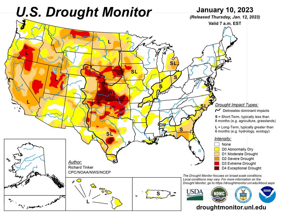
January 12, 2023 - A series of atmospheric rivers (AR) led to heavy rain and high-elevation snow across parts of the West, especially across California. Precipitation totals exceeding 4 inches (liquid-equivalent) were widespread, and several areas in and near the Sierra Nevada, Cascades, and coastal ranges recorded over one foot of precipitation. Moderate to heavy precipitation was also common along the coast and in the higher elevations of the Pacific Northwest, some higher elevations in the central and northern Rockies, part of the upper Midwest, portions of the lower Mississippi Valley, the interior Southeast, and scattered locales across the Ohio Valley and the Northeast. Precipitation totals generally exceeded 1.5 inches, and topped 4 inches in parts of the Southeast, central Utah, and the higher elevations in the Pacific Northwest. Much of the precipitation fell on areas experiencing dryness and drought, so across the country, improvement was much more common than deterioration. Mild temperatures prevailed across the country except where significant precipitation was observed in the northern Plains and Far West. Daily high temperatures averaged more than 12 deg. F above normal in central and southern Texas while daily low temperatures averaged 10 to 13 deg. F above normal across the Great Lakes, the Southeast, and the southern Plains.
Northeast
Much of the Northeast remains drought-free except for lingering long-term moderate (D1) drought across eastern Long Island. Light to locally moderate precipitation fell across most of the region, engendering the removal of some D0 in New York and New England. Despite recent precipitation, USGS groundwater levels remain below the 25th percentile where abnormal dryness (DO) was maintained.
Southeast
Heavy precipitation fell on a swath stretching from Louisiana and adjacent Texas northeastward across the interior Southeast to the western Carolinas and southern Appalachians. Scattered areas from southern Mississippi through northern Georgia and the adjacent Carolinas recorded 3 to locally 5 inches of precipitation. In contrast, areas in the coastal plains of the Southeast and across much of Florida, only light precipitation was observed. This pattern created several areas of notable improvement in D0 and D1 areas from central and southern Alabama through extreme southern Virginia, with severe (D2) drought improving to moderate (D1) in the central Florida Panhandle and adjacent areas. Farther east, where much less precipitation fell, some deterioration occurred in a swath from southern Georgia through the eastern Carolinas. Moderate drought was introduced in parts of eastern South Carolina, and severe (D2) drought expanded eastward in northern Florida and adjacent Georgia.
South
Moderate to locally heavy rain in Tennessee and Mississippi kept those states free from drought. The small area of D0 remaining in Tennessee was removed, and D0 areas in Mississippi contracted slightly. Moderate to locally heavy rain also fell on most of Louisiana and eastern Texas, reducing the extent of D0 in northern Louisiana and improving the west side of the D0 and D1 areas in the Bayou. Farther west, little or no precipitation fell. Exacerbated by much above normal temperatures, conditions deteriorated in portions of Texas and Oklahoma, although most locations were unchanged by the week’s dryness. Much of Oklahoma remained in extreme drought (D3), and similarly dry conditions existed across scattered areas in central and northern Texas. Exceptional drought (D4) now covers part of central Texas, scattered areas across Oklahoma, along with the northern tier of the state. 90-day precipitation amounts were only 10 to 25 percent of normal through the Oklahoma Panhandle, part of adjacent Texas, and in far western Texas from Big Bend National Park northwestward for a few hundred miles along the Rio Grande. Locations in and near the central Texas D4 region recorded 3 to 5 inches less precipitation than normal during this period.
Midwest
It was a wet week across most of Kentucky, with many locations from east of the Ohio/Mississippi Rivers’ confluence to the Appalachians receiving 1 to locally 4 inches. Meanwhile, light to locally moderate precipitation fell on portions of Minnesota and the Great Lakes Region, much of it in the form of snow. Most areas recorded several tenths of an inch of precipitation (liquid-equivalent), but a few swaths from southeastern Minnesota through the Upper Peninsula of Michigan reported 1 to 2 inches. A fairly deep snowpack now covers most areas across the northern tier of the Midwest Region. As a result, improvements were introduced there, particularly from the Upper Peninsula of Michigan through southern Minnesota. Most areas from eastern Missouri northeastward through much of the Lower Peninsula of Michigan recorded 2 to 6 inches less than normal precipitation over the last 3 months, with the largest deficits observed near the Ohio River; however, most of the Midwest Region has seen near- to above-normal precipitation during the past 30 days, with totals about 2 inches above normal through much of the northern tier of the Region. Currently, northwestern Iowa is the driest part of the Region. Much of this area is in extreme drought (D3) with a small area of D4 assessed near the Nebraska border.
High Plains
Most of the Region was much drier than the prior week, with a few tenths of an inch of precipitation restricted to southeastern South Dakota and adjacent portions of Nebraska, as well as isolated sites in the higher elevations of Colorado and southern Wyoming. Other areas recorded little if any precipitation. Most of the region remained unchanged from last week, but some improvement occurred in southeastern South Dakota and adjacent Nebraska. No areas appeared to deteriorate significantly due to the heavy precipitation of the previous week and seasonably cold temperatures reducing human and natural water demand. But most of the region remained in at least moderate drought (D1), with extreme to exceptional drought (D3-D4) stretching from southeastern Wyoming eastward across most of Nebraska into adjacent Iowa, and southward from western Nebraska through most of southern and western Kansas. A broad swath covering the southwestern half of Kansas and much of northeastern Nebraska remained in exceptional drought (D4).
West
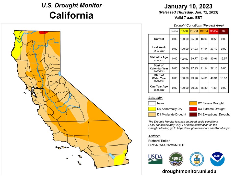
A long-term drought, dating back to the 2019-2020 winter, continues across California, the Great Basin, and parts of the Pacific Northwest. However, the intense precipitation in California the past few weeks – particularly late December and early January – has significantly reduced drought intensity in California. Most of the state saw a 1-category improvement this week. The D3 across interior northern and central California that covered over 35 percent of the state two weeks ago, is now confined to a small area adjacent to Oregon. But Despite the record and near-record precipitation over the past 6 weeks, large parts of the state remain in D1-D2 since moisture deficits have been entrenched across some areas for the last 2-3 years. At least one-third of the state has been in drought (D1+) since February 2020.
On January 9, Bishop CA reported 3.02 inches of rain, which was the fourth wettest day in at least 71 years. Their water-year total of 6.8 inches is more than 4 times normal. In the 41 days since December 1, 2022, downtown Sacramento reported 14.25 inches of precipitation where the normal is only 4.76 inches. The 16.10 inches received by Oakland during this period is more than 11 inches above normal (over 3 times normal). Farther south, Santa Maria reported 10.61” for the 41-day period, compared to a normal of 2.96 inches (over 3.5 times normal). Amounts in a few spots where precipitation is normally enhanced by orography have reported 30 to 48 inches of precipitation (liquid-equivalent) since December 1. Flooding and strong winds have been widespread during the stormiest periods.
The precipitation has provided a generous boost to reservoir stores, but most are still below the long-term average for this time of year. The Shasta Dam reservoir water stores rose from less than 1.4 million acre-feet (af) on November 30 to over 1.9 million af on January 10, with an increase of over a quarter-million af in the last 3 days of this week; however, the reservoir is still considerably below the long-term average for this time of year (2.5 million af) having risen from 57 percent of the long-term average to 70 percent. The sum of the state’s 6 largest reservoir stores increased from 5 million af on November 30, 2022 to 7.3 million af on January 10, 2023 (from 54 percent of long-term average to 74 percent of long-term average). Only one of the 6 largest reservoirs is near its long-term average, and 3 of them hold only 43 to 61 percent of their long-term averages as of January 10.
Caribbean
A few inches of rain removed D0 conditions in northeastern Puerto Rico, but lesser amounts fell farther to the south and west, leaving other D0 areas on the island unchanged.
Short-term abnormal dryness was removed from St. John this week, after rain totaled 1.61 inches at Windswept Beach, improving 1-month precipitation statistics enough to go out of the abnormal dryness category. More variable but overall lesser rainfall fell on St. Thomas and St. Croix this week, and short-term abnormal dryness continued on both islands.
Pacific
Alaska remains drought-free.
In Hawaii, producers on Maui and the Big Island report improved rangeland conditions following heavy precipitation from a mid-December storm, prompting some improvement on parts of these islands. But the past few weeks have been unfavorably dry, leading to the introduction of abnormal dryness (D0) across areas not in any dryness the prior week, including most of Kauai and portions of Oahu, Molokai, Lanai, Maui, plus the east side of the Big Island.
Author(s):
Richard Tinker, NOAA/NWS/NCEP/CPC
Curtis Riganti, National Drought Mitigation Center
Dryness Categories
D0 Abnormally Dry—used for areas showing dryness but not yet in drought, or for areas recovering from drought.
Drought Intensity Categories
D1 Moderate Drought
D2 Severe Drought
D3 Extreme Drought
D4 Exceptional Drought
Drought or Dryness Types
S Short-term, typically less than 6 months (agriculture, grasslands)
L Long-term, typically more than 6 months (hydrology, ecology)
SL Area contains both short- and long-term impacts
Source: National Drought Mitigation Center

