


Includes Merced, Madera and Mariposa Counties
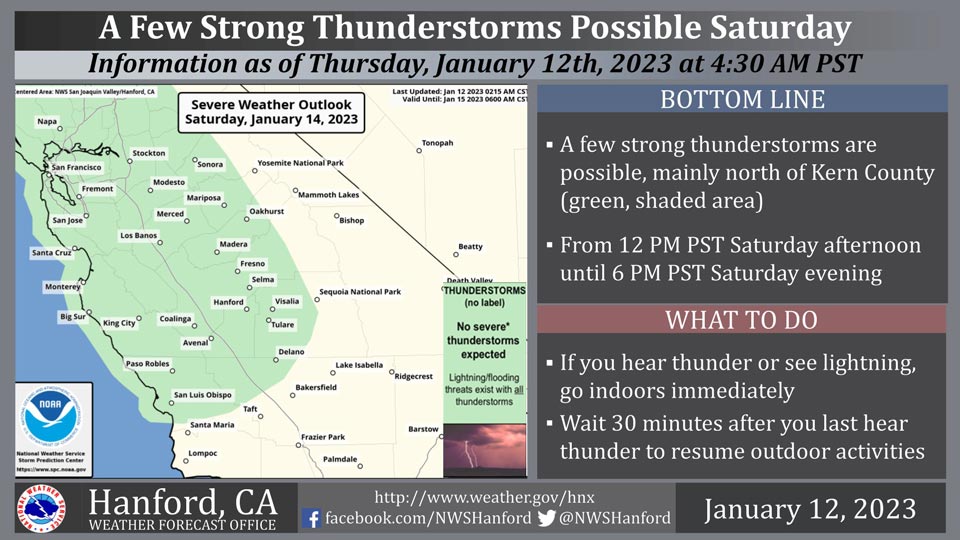
January 12, 2023 - The National Weather Service Hanford Office reports a few strong thunderstorms are possible, mainly north of Kern County Saturday.
Small hail and wind gusts near 45 miles per hour are a couple of hazards associated with strong thunderstorms.
In addition to dangerous cloud to ground lightning strikes, any thunderstorm can produce intense rainfall rates, leading to localized flooding.
Area Forecast Discussion
National Weather Service Hanford CA
355 AM PST Thu Jan 12 2023
.SYNOPSIS...
Dry weather will prevail through early Friday but dense fog is
possible in the San Joaquin Valley. Another storm system may
arrive by Friday afternoon with more wet weather likely over the
weekend.
&&
.DISCUSSION...
Brief storm passage across Central California is now shifting
north as additional precipitation now falls over Northern
California. While the potential for fog will now increase, enough
wind mixing still exist over the San Joaquin Valley this morning
to keep any formation at a minimum. Therefore, will expect patchy
fog this morning with visibility values dropping to 1 to 2 miles
in the worst spots. The dry and possibly foggy conditions are
being driven by a ridge pattern currently over the state. This
ridge pattern is steering the latest disturbance north and
avoiding the district. Yet, while some stronger winds still exist
over Central California, the passage of the ridge pattern will
diminish the winds and increase the fog potential going into
Friday. Satellite and Ensemble model upper-air analysis shows the
next disturbance at our door-step as more unsettled weather is
expected on Friday and this weekend.
Ensemble upper-air analysis has a good handle on ridge axis
placement and the potential track the ridge will take in the next
24 to 36 hours. In the very short term, will monitor the possible
fog situation for any changes in fog growth. Beyond the next two
mornings, ensemble precipitation analysis has been consistent in
its timing for precipitation onset. Dynamic Ensemble-based (DESI)
analysis shows the onset of light precipitation starting Friday
morning with increasing chances of measurable precipitation later
in the day on Friday. Will expect the end of the week disturbance
to overrun the district Friday night into Saturday. During this
time and into later Saturday, ensemble analysis places the bulk of
the storms precipitation over Central California. In agreement
with Weather Prediction Center assessment of a possible Excessive
Rainfall Event over the area on Saturday. A winter storm watch is
currently in effect for the Sierra Nevada for a range from 4000 to
5000 feet as heavy precipitation falls across the mountains this
weekend. Integrated Water Vapor analysis for the end of week storm
has the potential of becoming an Atmospheric River (AR). Yet,
that potential is slightly lower then the events that recently hit
Central California. However, the impact will be high as the
reprieve (dry period) from precipitation was short and we are
still in recovery mode.
Ensemble Cluster Analysis is still maintaining a good signal
toward the continuation of the unsettled pattern. Therefore, will
keep the possibility of precipitation going through at least next
Wednesday. Yet, while a strong signal exist toward unsettled
conditions early in the longer range period, Cluster Analysis
attempts to re-introduce a ridge pattern near the day seven period
of next Thursday. Yet, with higher uncertainty during the period
of transition, will lean toward continued unsettled weather
through at least next Thursday. Will have to continue dealing with
the problems associated with more water over the region.
&&
.AVIATION...
Across the Sierra Nevada, areas of mountain obscuring MVFR/IFR
conditions in low clouds. VFR/MVFR conditions will prevail across
the rest of the district.
&&
.AIR QUALITY ISSUES...
On Thursday January 12 2023,Fireplace/Wood Stove Burning Status
is: No Burning Unless Registered in Fresno and Kern Counties.
Burning Discouraged in Kings, Madera, Merced, and Tulare Counties,
and Kern (Greater Frazier Park Area) and Sequoia National Park
and Forest.
&&
.CERTAINTY...
The level of certainty for days 1 and 2 is high.
The level of certainty for days 3 through 7 is medium.
Certainty levels include low...medium...and high. Please visit
www.weather.gov/hnx/certainty.html for additional information
and/or to provide feedback.
&&
.HNX WATCHES/WARNINGS/ADVISORIES...
Winter Storm Watch from late Friday night through Tuesday
afternoon for CAZ323-326>331.
Source: NWS

