


Includes Merced, Madera and Mariposa Counties and Yosemite
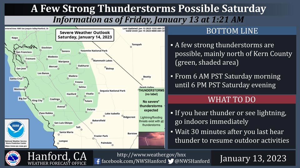
January 13, 2023 - The National Weather Service Hanford Office reports a few strong thunderstorms are possible, mainly north of Kern County Saturday.
Small hail and wind gusts near 45 miles per hour are a couple of hazards associated with strong thunderstorms.
In addition to dangerous cloud to ground lightning strikes, any thunderstorm can produce intense rainfall rates, leading to localized flooding.
Area Forecast Discussion
National Weather Service Hanford CA
252 AM PST Fri Jan 13 2023
.SYNOPSIS...Another storm system will arrive into central
California by this afternoon and bring another period of moderate
to locally heavy precipitation through Saturday evening. More wet
weather is anticipated later on in the holiday weekend. Drier
conditions are expected by the middle of next week.
&&
.DISCUSSION...IR imagery showing increasing mid/high clouds
moving into central CA ahead of another strong upper trough which
is expected to spread precipitation into our area by this
afternoon and bring moderate to locally heavy rain and mountain
snowfall to our area tonight and Saturday. As a result of the
increased cloud cover this morning, fog coverage in the San
Joaquin Valley will be limited to a few patches. Some strong
downslope winds gusts will be possible over the West Side Hills
through early this afternoon and a Wind Advisory remains in effect
for the West Side Hills until 100 pm PST this afternoon.
SREF indicating a deep moisture surge pushing into the area this
afternoon and will spread widespread precipitation across our
area by this evening. Strong upper jet dynamics are progged for
our area on Satruday afternoon and evening with central CA in the
favorable left front quadrant of a 170+ kt 250 mb jet max. This
will combine with the abundant moisture and bring our area
another period of moderate to heavy precipitation with heavy
snowfall possible above 6000 feet. A Winter Storm Warning remains
in effect for the Sierra Nevada between 1000 am PST Saturday and
400 am Tuesday as a second system is progged to move through our
area during Martin Luther King holiday and bring additional
snowfall to the Sierra Nevada. Below the snow line, more flooding
will be possible in the San Joaquin Valley, West Side Hills,
Sierra foothills and Kern River Canyon areas and an Aerial FLood
Watch remains in effect for these areas between 1000 am PST
Saturday and 700 am PST Sunday. QPF progs are indicating between
0.75 and 1.25 inches of rainfall for the central San Joaquin
Valley and between 0.50 and 1 inch of rainfall for the south San
Joaquin Valley. Between 1.25 and 2.50 inches of rainfall is
expected over the Sierra foothills and 2 to 4 inches of liquid
precipitation across the higher Sierra Nevada. Latest NBM
probabilistic guidance is indicating between a 15 and 40 percent
chance of excessive rainfall in the Sierra Nevada below the snow
line and across the Sierra foothills Saturday afternoon and
Saturday night. In addition, the 06Z HRRR and NAM are both
indicating instability and CAPE will be sufficient for at least
isolated thunderstorms along the West Side Hills and the San
Joaquin Valley late Saturday afternoon and Saturday evening.
A brief respite is expected on Sunday before another upper trough
moves through central CA on Sunday night and during the Martin
Luther King Day holiday. This system will provide our area with
additional precipitation with QPF progs indicating another 0.30
to 0.60 inches of rainfall for most of the San Joaquin Valley and
0.75 to 1.50 inches of rainfall for the Sierra foothills. Between
1.50 and 2.50 inches of additional liquid precipitation is
expected across the Sierra Nevada with the total snowfall from the
two systems combined expected to reach 2 to 4 feet with local
amounts up to 5 feet above 6000 feet. Snow levels are expected to
be a bit lower with the second system and will lower to around
4000 feet by Monday evening with light snowfall possible along the
major passes in Kern County on Monday evening. The second trough
will move to the east of our area on Tuesday, but cyclonic flow
will keep chances of showers going through at least Tuesday
morning.
Shortwave ridging will bring drier conditions to central CA on
Wednesday before an inside slider type system clips our Merced
County and the Sierra Nevada with some light precipitation on
Wednesday night. Ensemble members are now in excellent agreement
an building an upper ridge off the CA coast on Thursday and
building inland slightly next Friday. This will result in a cool
and dry northerly flow over our area during the latter portion of
next week which will result in dry conditions for our area along
with below normal temperatures.
&&
.AVIATION...Across the Sierra Nevada, areas of mountain obscuring
IFR conditions in low clouds, becoming widespread mountain
obscuring IFR in clouds and precipitation after 00Z Sat. Across
the San Joaquin Valley, West Side Hills and Sierra foothills,
increasing areas of MVFR in low clouds and rain after 00Z Sat with
local IFR in rain and mist. Across the Tehachapi Mountains,
increasing areas of MVFR with local mountain obscuring IFR in low
clouds and precipitation after 00Z Sat. Otherwise, VFR conditions
will prevail over the next 24 hours.
&&
.AIR QUALITY ISSUES...On Friday January 13 2023, Fireplace/Wood
Stove Burning Status is: Burning Discouraged in Fresno, Kern,
Kings, Madera, Merced, and Tulare Counties, and Kern (Greater
Frazier Park Area) and Sequoia National Park and Forest.
&&
.CERTAINTY...
The level of certainty for days 1 and 2 is high.
The level of certainty for days 3 through 7 is medium.
Certainty levels include low...medium...and high. Please visit
www.weather.gov/hnx/certainty.html for additional information
and/or to provide feedback.
&&
.HNX WATCHES/WARNINGS/ADVISORIES...
Wind Advisory until 1 PM PST this afternoon for CAZ300-304-308-
313-335-336.
Flood Watch from Saturday morning through Sunday morning for
CAZ300>322-324-325-329-330-332-334>336.
Winter Storm Warning from 4 AM Saturday to 4 AM PST Tuesday for
CAZ323-326>331.
Source: NWS

