


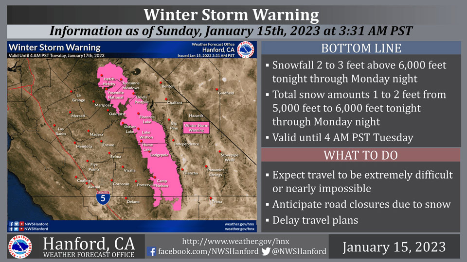
January 15, 2023 - The National Weather Service Hanford Office reports a Winter Storm Warning is in effect for the Sierra Nevada until 4:00 A.M. Tuesday.
The majority of this snow will fall Monday.
Travel will be extremely difficult or impossible. If you plan to travel, consider alternate strategies. If you must travel, remember to carry tire chains, plenty of food, a good deal of water, warm clothing, and a flashlight in your vehicle.
Winter Storm Warning
URGENT - WINTER WEATHER MESSAGE
National Weather Service Hanford CA
949 AM PST Sun Jan 15 2023

Yosemite NP outside of the valley-Upper San Joaquin River-
Kaiser to Rodgers Ridge-Kings Canyon NP-Grant Grove Area-
Sequoia NP-South End of the Upper Sierra-
Including the cities of Tuolumne Meadows, Wawona,
Devils Postpile, Florence Lake, Lake Thomas Edison, Lake Wishon,
Huntington Lake, Shaver Lake, Cedar Grove, Grant Grove,
Hume Lake, Giant Forest, Lodgepole, and Johnsondale
949 AM PST Sun Jan 15 2023

...WINTER STORM WARNING REMAINS IN EFFECT UNTIL 4 AM PST
TUESDAY...

* WHAT...Heavy snow expected. From tonight until Monday night. 1
  to 2 feet of snow is possible.

* WHERE...Sierra Nevada at elevations mainly above 5,000 feet
  from Yosemite to Tulare County. Snow levels will lower on
  Monday night to around 4,000 feet before snow ends.

* WHEN...From 4 PM PST this afternoon until 4 AM PST Tuesday.

* IMPACTS...Travel could be very difficult to impossible. The
  hazardous conditions could impact the morning or evening
  commute.


PRECAUTIONARY/PREPAREDNESS ACTIONS...

If you must travel, keep an extra flashlight, food, and water in
your vehicle in case of an emergency.

The latest road conditions for the state you are calling from can
be obtained by calling 5 1 1.
Source: NWS

