


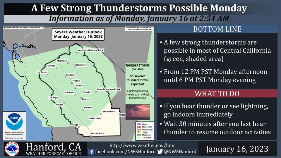
Includes Merced, Madera, Mariposa Counties and Yosemite National Park
January 16, 2023 - The National Weather Service Hanford Office reports a few strong thunderstorms are possible in most of Central California from 12:00 P.M. Monday afternoon until 6:00 P.M. Monday evening.
Small hail and wind gusts near 45 miles per hour are a couple of hazards associated with strong thunderstorms.
In addition to dangerous cloud to ground lightning strikes, any thunderstorm can produce intense rainfall rates, leading to localized flooding.
Area Forecast Discussion
National Weather Service Hanford CA
357 AM PST Mon Jan 16 2023
.SYNOPSIS...
Another storm will impact Central California, with heavy mountain
snow and additional lower elevation rainfall through early Tuesday.
Flooding concerns will continue in some foothill and San Joaquin
Valley areas, especially Merced. A weaker system will bring some
light precipitation Wednesday night into Thursday then dry and
seasonably cool weather will prevail Friday through the weekend.
&&
.DISCUSSION...
Unsettled weather continues for central California with an upper
trough situated over the west coast. Radar imagery shows scattered
light to moderate showers across the southern Sierra Nevada with
some heavier activity over the SF Bay area and Sacramento Valley.
Hi-res guidance shows precipitation increasing in both coverage
and intensity across the Sierra later this morning. Instability
looks to be sufficient for daytime heating to spark some isolated
thunderstorms this afternoon and evening. Storms will be capable
of producing heavy downpours, small hail, and gusty winds. Things
begin to wind down later this evening with showers tapering off
from north to south. Expect just a few light mountain showers by
Tuesday morning, mainly across the upslope regions in Kern County.
Snow levels are around 5000 feet and will lower to around 3500 ft
tonight. A Winter Storm Warning remains in effect for the Sierra
Nevada with an additional 1 to 3 feet of snow possible. A Winter
Weather Advisory is in effect for the Kern County Mountains with
potential for some light snow accumulations on the major highway
passes. Latest blended guidance gives the Tehachapi Pass a 52%
probability of getting 1" of snow. The Tejon Pass has only a 15%
probability of getting 1" of snow but there is a 54% probability
for a dusting of snow. Rainfall amounts of 1 to 3 inches remain
possible in the Sierra below the snow line and into the foothills.
Travel along mountain roads will remain hazardous as rivers and
streams are running high and the ground is saturated. Additional
rock slides, mud slides, and debris flows remain possible. Rain
across the San Joaquin Valley will create more nuisance flooding
in low lying and poor drainage areas.
Transitory short wave ridging moves over Tuesday night through
Wednesday ahead of a fast moving trough to the north. This s/wv
looks to track more inland as it provides mainly the Sierra with
a chance of precipitation late Wednesday night through Thursday.
Model ensembles continue to favor a dry pattern for the end of
the week and into next weekend. Upper ridging over the eastern
Pacific looks to keep us in a cool but dry northerly flow aloft.
&&
.AVIATION...
VFR/MVFR conditions will prevail across the San Joaquin Valley for
the next 24 hours local IFR conditions possible in heavier showers
and isolated thunderstorms. MVFR/IFR conditions with local terrain
obscuration likely across the Sierra Nevada, the Foothills, the
West Side Hills, and the Tehachapi Mountains due to the clouds and
precipitation.
&&
.AIR QUALITY ISSUES...
On Monday January 16 2023,Fireplace/Wood Stove Burning Status is:
Burning Discouraged in Fresno, Kern, Kings, Madera, Merced, and
Tulare Counties, and Kern (Greater Frazier Park Area) and Sequoia
National Park and Forest.
&&
.CERTAINTY...
The level of certainty for days 1 and 2 is high.
The level of certainty for days 3 through 7 is medium.
Certainty levels include low...medium...and high. Please visit
www.weather.gov/hnx/certainty.html for additional information
and/or to provide feedback.
&&
.HNX WATCHES/WARNINGS/ADVISORIES...
Winter Storm Warning until 4 AM PST Tuesday for CAZ323-326>331.
Winter Weather Advisory from 10 AM this morning to 7 AM PST
Tuesday for CAZ333>336.
Wind Advisory until 7 AM PST this morning for CAZ334>336.
Source: NWS

