


California and National Drought Summary for January 17, 2023
Summary
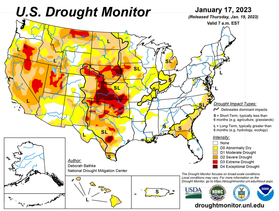
January 19, 2023 - An atmospheric river brought heavy rain and high-elevation snow across part of the West, leading to drought improvements in California, the Pacific Northwest, the northern Rockies and the Great Basin. A band of heavy rainfall, combined with severe weather, impacted the Southeast, leading to areas of drought improvement in Georgia. Meanwhile, persistent dryness led to the expansion of drought in the Carolinas. Drought in the High Plains remains largely unchanged; much of the excess moisture is tied up in snowpack and its effects on soil moisture and groundwater recharge remain to be seen. Drought expanded across parts of the South where short-term moisture deficits on top of longer-term drought continue to build.
Northeast
Much of the Northeast remains drought-free except for lingering long-term moderate (D1) drought across eastern Long Island. Despite recent improvement, precipitation departures are close to 6 inches below normal over the last 60 days. The U.S. Geological Survey also shows persistently low streamflow and groundwater levels. Abnormal dryness (D0) expanded across southern New Jersey and in the Eastern Panhandle of West Virginia where short-term precipitation departures continue to grow, streamflows remain low and soils are dry.
Southeast
The Southeast saw a mix of drought improvement and expansion. A swath of heavy precipitation stretched from Alabama to Virginia. The excess rainfall improved areas of abnormal dryness (D0) in Alabama; severe and moderate (D1-D2) drought and abnormal dryness in Georgia; D0 and D1 conditions in South Carolina; and abnormal dryness in Virginia. Short-term rainfall deficits, streamflow and soil moisture showed improvement in these areas. South Carolina and North Carolina, however, saw expansions of D0 and D1 in areas that missed out on the heaviest rain. Precipitation deficits range from 4 to 6 inches over the last 90 days. Streamflow, groundwater and soil moisture are also low.
South
Much of Oklahoma and Texas missed out on this week’s precipitation events, resulting in the expansion of drought. In Oklahoma, temperatures averaged 10 to 13 degrees above normal over the previous 2 weeks while precipitation has been less than 50% of normal over the past 4 months. Extreme (D3) drought expanded in response to well-below-normal (10th percentile or lower) measurements of streamflow, groundwater and soil moisture conditions. Texas also saw a swath of degradations from the north-central region to South Texas where short-term moisture deficits, on top of longer-term drought, have continued to build, and streamflow, soil moisture and groundwater levels range from below (10th to 24th percentile) to well below normal (10th percentile or lower). In the eastern part of the region, last week’s rainfall erased lingering areas of abnormal dryness.
Midwest
The Midwest saw a mix of drought improvement and expansion last week. Heavy precipitation (150 to over 300% of normal) in Ohio and Indiana led to improvements in moderate (D1) drought and abnormal dryness (D0) where streamflows and soil moisture show signs of recovery. Missouri, though, saw an expansion of severe (D2) drought based on increasing precipitation deficits (6 to 12 inches over the last 6 months) and declining streamflows. Continued below-normal precipitation led to an expansion of D0 in Illinois and far southeast Wisconsin as streamflows have begun to decline.
High Plains
Much of the High Plains remained in a holding pattern last week. Areas that received abundant snowfall over the Water Year are slow to make improvements due to the long-term nature of drought in the region. Until spring melt shows verified evidence of soil moisture and groundwater recharge, it will be difficult to tell how much effect snow has had on drought conditions. Severe (D2) drought improved in eastern North Dakota, which has received 16 to 20 inches of snow this season. No areas deteriorated significantly, except for areas of abnormal dryness (D0) in South Dakota and Colorado.
West
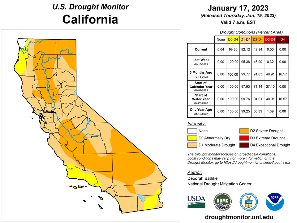
The long-term drought continues across California, the Great Basin and parts of the Pacific Northwest. However, a barrage of atmospheric river events – streams of moisture in the atmosphere that transport water vapor from the tropics – has reduced the drought intensity over the past few weeks. In California, 1-category improvements were made along the Northern Coast, around the Delta and along the South Coast region. While precipitation over much of the state was over 300% of normal over the previous 2 weeks (2 to 12.5 inches, depending on location), deficits have been years in the making. While this last round of rain has helped return smaller reservoirs to the historical averages, many of the larger reservoirs still remain below the historical average for this time of year. Historically, long-term drought is interrupted by a period of abnormally wet weather. However, it’s too early to tell if the wet weather is enough to end the drought. Many other parts of the West also saw improvements to drought and abnormally dry areas. In Oregon, 1-category improvements were made to extreme (D3) and severe (D2) drought in the southeast and near Klamath County based on above-average snow water equivalent and improvements to long-term indicators such as 6- to 24-month precipitation and shallow groundwater. In Idaho, severe (D2) and moderate (D1) drought improved where precipitation deficits over the past 12 months and streamflows show improvement. In Utah, areas of D3 and D2 improved based on precipitation in excess of 300% of normal (3 to 10 inches, depending on location) over the last 30 days and its resulting effect on streamflows, soil moisture, and groundwater. Heavy precipitation helped erase areas of abnormal dryness in parts of Washington, Oregon, western Wyoming, western Colorado, Arizona and New Mexico. The only places in the West seeing an expansion of drought were Oregon and Colorado. In Oregon, D1 was introduced in the south Willamette Valley and central Oregon Cascades and D1 and D2 expanded in the north-central part of the state. These expansions were in response to below-normal water-year-to date precipitation on top of longer-term deficits and groundwater impacts.
Caribbean
In Puerto Rico, no changes were made to the map this week.
Variable rainfall across the U.S. Virgin Islands led to no changes in the depiction, with short-term dryness (D0-S) persisting on St. Thomas and St. Croix. Rainfall was heavier on St. John, which remained free of dryness, with 2 to 3 inches reported at the two volunteer (CoCoRaHS) observation sites. The observer at Windswept Beach, St. John, received measurable rain on each of the first 16 days of January, totaling 3.89 inches – above the long-term January mean of just under 3 inches.
Meanwhile, December 1 – January 16 rainfall totaled less than 50 percent normal at the airport observation sites on St. Thomas and St. Croix. During that 47-day period, rainfall totaled just 2.06 inches at King Airport on St. Thomas and 1.94 inches at Rohlsen Airport on St. Croix. CoCoRaHS observations showed isolated heavier showers during the 7-day drought-monitoring period, with weekly amounts ranging from 0.20 to 0.75 inch on St. Thomas and 0.23 to 2.20 inches on St. Croix. U.S. Geological Survey well observations exhibited slight increases in depth to water on St. Thomas and St. Croix, consistent with short-term dryness.
Pacific
In Alaska, no changes were made to the map this week.
In Hawaii, dry conditions continued. Kauai, Oahu, Maui and the Big Island all saw drought conditions worsen as rainfall deficits increased, leading to reductions in streamflow and stressed vegetation, as well as island-specific impacts. For example, on Maui, the county water treatment facility near Kaanapali shut down due to a lack of streamflow. On the Big Island, catchment supplies are running out and pastures are not growing so ranchers have been forced to haul water.
In the U.S.-Affiliated Pacific Islands (USAPI), the only change was to remove abnormal dryness from Ulithi in the Federated States of Micronesia (FSM), due to weekly rainfall totaling more than 6 inches. As a result, the only USAPI location with any drought designation was Kapingamarangi, FSM, which remained in severe drought (D2-SL). Elsewhere in the FSM, data from Pingelap was again missing, while a few other locations have trended drier in recent days but are not yet candidates for abnormal dryness.
In contrast, ample rain continued to fall across the Republic of Palau, while extremely wet conditions have prevailed this month in the Marianas and American Samoa. In the Marianas, Guam International Airport netted 13.66 inches (452 percent of normal) during the first 17 days of January, within reach of the two highest January totals on record: 18.09 inches in 1976 and 16.89 inches in 2014. The Republic of the Marshall Islands (RMI) experienced a decrease in rainfall during the drought-monitoring period, but remained wet in the wake of early-January downpours. For example, Mili, RMI, received weekly rainfall of 2.26 inches, following the previous week’s 9.39-inch deluge. Data for Utirik, RMI, remained missing.
Looking Ahead
The National Weather Service Weather Prediction Center forecast for the remainder of the week (valid January 18 – January 20) calls for a winter storm to bring freezing rain and snowfall to the High Plains and Upper Midwest. To the southeast, showers and thunderstorms are expected with localized areas of heavy rainfall. Chances will increase for a wintry mix of snow, sleet and freezing rain along the East Coast as the storm system moves into the northeast on Thursday. Much of the southern U.S. can expect unseasonably warm temperatures. Meanwhile, another storm system is expected to move southeastward through the Pacific Northwest into the Northern Rockies, the Great Basin, California and the Desert Southwest, bringing rain and snow at lower elevations and heavier mountain snow. Moving into next week (valid January 21 – January 25), the forecast calls for a storm system to track from the central Plains to the Northeast, bringing strong winds and wintry weather to the northern regions and rain to the south. At 8 – 14 days, the Climate Prediction Center Outlook (valid January 25 – January 31) calls for below-normal temperatures over most of the country except for the Northeast, Southeast and Alaska. The Northeast can expect near-normal temperatures, while the Southeast and Alaska have the greatest probability of warmer-than-normal temperatures. Most of the U.S. can expect near- to slightly above-normal precipitation. Only the Pacific Northwest and northern Minnesota have increased odds for below-normal precipitation.
Author(s):
Deborah Bathke, National Drought Mitigation Center
Brad Rippey, U.S. Department of Agriculture
Dryness Categories
D0 Abnormally Dry—used for areas showing dryness but not yet in drought, or for areas recovering from drought.
Drought Intensity Categories
D1 Moderate Drought
D2 Severe Drought
D3 Extreme Drought
D4 Exceptional Drought
Drought or Dryness Types
S Short-term, typically less than 6 months (agriculture, grasslands)
L Long-term, typically more than 6 months (hydrology, ecology)
SL Area contains both short- and long-term impacts
Source: National Drought Mitigation Center

