


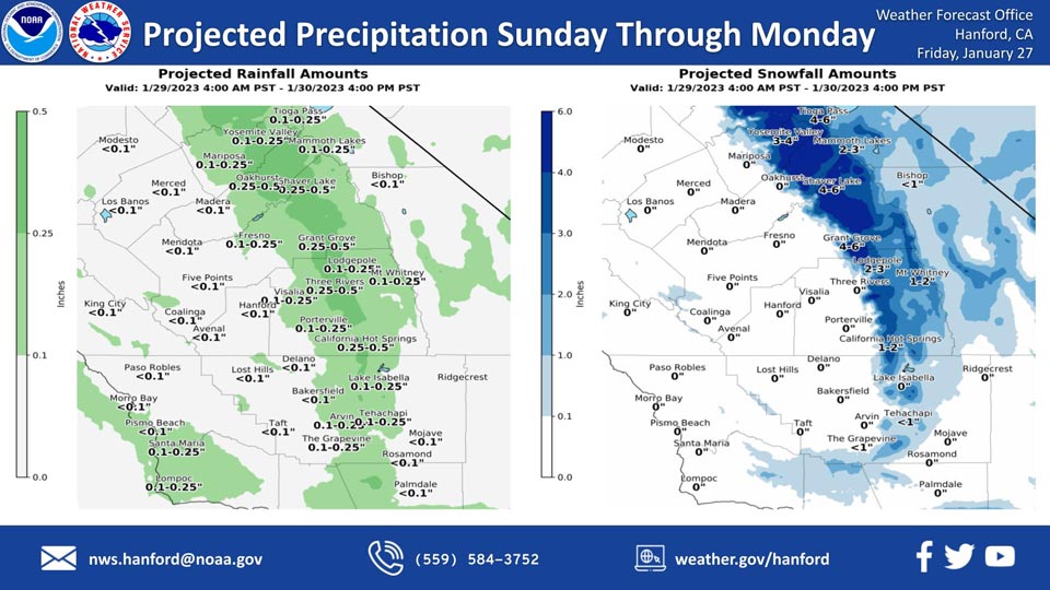
Projected Precipitation for Mariposa 0.10"- 0.25"
Projected Precipitation for Oakhurst 0.25"- 0.50"
Projected Precipitation for Yosemite Valley 0.10"- 0.25"
January 27, 2023 - The National Weather Service Hanford Office reports a storm system will impact Central California Sunday through Monday, resulting in a chance of rain in the San Joaquin Valley and light snow in the Sierra Nevada and adjacent foothills.
Snow levels will start at around 3,000 feet Sunday, before dropping to about 2,000 feet Sunday night.
The majority of this precipitation will fall Sunday afternoon and Sunday evening.
Area Forecast Discussion
National Weather Service Hanford CA
241 AM PST Fri Jan 27 2023
.SYNOPSIS...
A storm system will drop southward through California on Sunday
and Monday bringing a chance of light rain and mountain snow to
the area. Freezing temperatures are likely across the San Joaquin
Valley Monday and Tuesday nights with upper 20s in rural areas.
&&
.DISCUSSION...
Ridge of high pressure over the Easter Pacific remains in control.
Satellite loops show some thin cirrus clouds spreading in from the
north, otherwise clear skies prevail over central California. Winds
are light across the San Joaquin Valley with visibilities generally
MVFR in mist and locally IFR. Tule Fog development remains possible
through sunrise with hi-res guidance indicating dense fog potential
down the center of the valley. Temperatures should top out in the
lower 60s across much of the SJV today, which is around 2-5 degrees
above climatological normals for late January. High pressure ridge
will shift west over the Eastern Pacific later today with a weak
s/wv trough dropping south over California tonight. This trough
may provide enough mixing to inhibit fog development Friday night.
Temperatures will cool to near normal on Saturday afternoon with
mostly upper 50s across the SJ Valley.
An upper trough will drop south over northern California on Sunday
the dig just off the coast of southern California on Monday. This
will bring a chance of generally light precipitation, increased
winds, and cooler temperatures. Moisture is limited but snow levels
will drop into the foothills. QPF gives as much as one half of an
inch liquid over the Sierra Nevada, one quarter of an inch in the
Tehachapi Mountains, and up to one tenth an inch in the SJ Valley.
Snow levels will start out around 3500' Sunday morning then lower
to 2000-3000' Sunday night and Monday. Blended guidance only gives
a 50% probability of 2 inches of snowfall for a few locations in
the Sierra. The probability drops to 25% for 4" and 25% and for
6". The Sierra Foothills should generally just see a dusting of
snow, but there is around a 20% probability of 1" down to around
3000'. Snow may fall along the major highway passes in Kern County
but the latest guidance is pessimistic on much if any accumulations.
Tehachapi Pass has just a 30% probability for a dusting of snow.
Even higher elevations in Kern County have only a 25% probability
for 1" of snow.
The trough then shifts over northern Baja CA on Tuesday with high
pressure building back in from the Pacific. A very cold air mass
will settle in and result in widespread freezing temperatures for
the San Joaquin Valley Monday night and Tuesday night. The latest
NBM probabilities for low temperatures of 32 degrees or lower are
80-100% for much of the SJV. The probability for low temperatures
of 28 degrees or lower are from 50-75% across a good portion of
the valley. Probabilities for freezing temperatures decrease on
Wednesday night but are still 50-60% for portions of the valley.
&&
.AVIATION...
In the San Joaquin Valley, widespread MVFR in mist with patchy
IFR/LIFR in fog through 18Z Friday. Otherwise, VFR conditions
will prevail across the central CA interior for the next 24 hours.
&&
.AIR QUALITY ISSUES...
On Friday January 27 2023, Unhealthy for Sensitive Groups in
Fresno, Kern, and Kings Counties. Fireplace/Wood Stove Burning
Status is: No Burning For All in Fresno and Kern Counties. No
Burning Unless Registered in Kings, Madera, Merced, and Tulare
Counties. Burning Discouraged in Kern (Greater Frazier Park Area)
and Sequoia National Park and Forest.
&&
.CERTAINTY...
The level of certainty for days 1 and 2 is high.
The level of certainty for days 3 through 7 is medium.
Certainty levels include low...medium...and high. Please visit
www.weather.gov/hnx/certainty.html for additional information
and/or to provide feedback.
&&
.HNX WATCHES/WARNINGS/ADVISORIES...
None.
Source: NWS

