


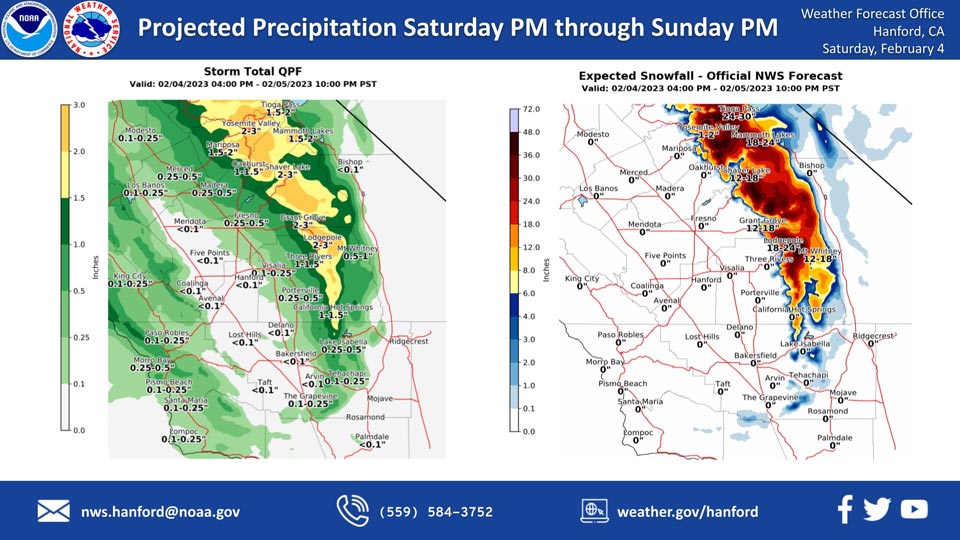
Projected Precipitation for Mariposa 1.00"- 1.50" Update: 1.50"- 2.00"
Projected Precipitation for Oakhurst 1.00"- 1.50" Update: No Change
Projected Precipitation for Yosemite Valley 2.00"- 3.00" Update: No Change
February 4, 2023 - The National Weather Service Hanford Office reports the next storm system will impact Central California Saturday night and Sunday, resulting in snow in the Sierra Nevada and rain in the San Joaquin Valley.
Snow levels will start at around 6,500 feet Saturday night, before dropping to about 4,000 feet by Sunday evening.
The majority of the precipitation will fall late Saturday night into Sunday morning.
Area Forecast Discussion
National Weather Service Hanford CA
342 AM PST Sat Feb 4 2023
.SYNOPSIS...
A disturbance will move through the area Tonight through Sunday
and bring rain to the San Joaquin Valley and snow to the Sierra
Nevada. Dry conditions return on Monday with frost and fog
possible in the San Joaquin Valley Tuesday morning.
&&
.DISCUSSION...
The precipitation across Northern California and portions of
Central California had a duration of less than 24 hours. As of
this morning, skies were mostly clear with fog forming over Merced
County and possibly extending south into Madera and Fresno
Counties. Will keep an eye on the fog development and the possible
extent before it burns off later this morning. The focus will now
be placed on the next storm this weekend and the impacts from
subtropical moisture and the dynamics from a jet-streak that will
combine to produce a significant weather event.
Ensemble solutions remain consistent in showing a more organized
storm hitting Central California starting Tonight. Ensemble
moisture analysis is still showing high confidence in placing a
good fetch of subtropical moisture over Central California tonight
and Sunday. Therefore, will expect enhanced precipitation rates
as models also place good jet-streak dynamics over Central
California during the time when deeper moisture is transported
through the region. Due to the moisture and dynamics being in-
phase, the atmospheric river crossing the area could touch on
Moderate Atmospheric River strength. Presently, models place the
heaviest precipitation over Central California on Sunday morning
as orographic effects allow for values to reach over one inch of
liquid water. Total precipitation values could reach 1 to almost 3
inches of liquid while the lower elevations will see around a
half to almost one inch of rain. Ensembles are expecting a well
defined weak atmospheric river. Some rain shadowing is also
expected which will lead to precipitation total closer to a tenth
of an inch or less. The lower values will be due to the
orientation of the southwesterly flow during the event.
Based on the precipitation totals, models are still placing snow
levels at 6500 feet at around the start of the event. Yet, with
the frontal passage still expected to occur early Sunday, will see
snow level lower to near 4000 feet by Sunday afternoon. This will
allow some lower elevations to see snow while the higher terrain
observed as much as two feet of new snow. Hopefully, the lower
snow levels will limit the threat of more water on an already
saturated ground. In addition, the track of better dynamics will
favor convective activity over Northern California on Sunday.
While some convective potential could bleed into Central
California, will follow the Storm Prediction Centers guidance and
mention thunderstorms from Fresno County northward later today and
on Sunday.
Longer range Ensemble Cluster Analysis show a very good signal
toward ridging after the exit of the disturbance on Monday.
Therefore, a dry period will return during the longer term
forecast ahead of yet another disturbance that may hit the area
around day seven (Saturday to Sunday). Uncertainty is too high to
define the event next weekend. Yet, will mention possible
precipitation on the seventh day.
&&
.AVIATION...
In the San Joaquin Valley, areas of MVFR in haze/mist with local
IFR in fog until 18Z today. Mountain obscuring IFR across the
higher terrain of the Sierra Nevada starting this evening.
Otherwise, VFR conditions will prevail across the Central CA
Interior for the next 24 hours.
&&
.AIR QUALITY ISSUES...
On Saturday February 4 2023, Fireplace/Wood Stove Burning Status
is: No Burning Unless Registered in Fresno, Kern, Kings, Madera,
Merced, and Tulare Counties. Burning Discouraged in Kern (Greater
Frazier Park Area) and Sequoia National Park and Forest.
&&
.CERTAINTY...
The level of certainty for days 1 and 2 is high.
The level of certainty for days 3 through 7 is medium.
Certainty levels include low...medium...and high. Please visit
www.weather.gov/hnx/certainty.html for additional information
and/or to provide feedback.
&&
.HNX WATCHES/WARNINGS/ADVISORIES...
Wind Advisory from midnight tonight to midnight PST Sunday night
for CAZ332>334-337>339.
Dense Fog Advisory until 10 AM PST this morning for CAZ301-302.
Winter Storm Warning from 7 PM this evening to 10 PM PST Sunday
for CAZ323>331.
Source: NWS

