


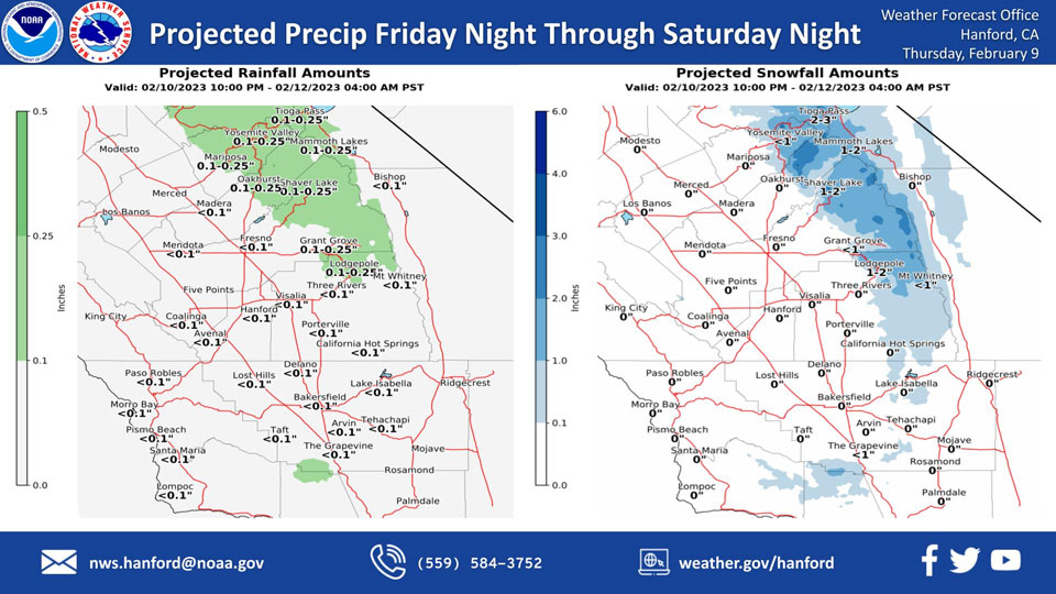
Projected Precipitation for Mariposa 0.10"- 0.25"
Projected Precipitation for Oakhurst 0.10"- 0.25"
Projected Precipitation for Yosemite Valley 0.10"- 0.25"
February 9, 2023 - The National Weather Service Hanford Office reports the next storm system will impact Central California Friday night through Saturday night, resulting in a chance of light snow in the Sierra Nevada and a slight chance of light rain in the San Joaquin Valley.
Snow levels will start at around 5,000 feet Friday night, before dropping to about 4,000 feet Saturday.
The majority of this precipitation will fall late Friday night into Saturday morning.
Area Forecast Discussion
National Weather Service Hanford CA
247 AM PST Thu Feb 9 2023
.SYNOPSIS...
Dry and cool conditions will continue until Saturday. A Dense
Fog Advisory is active from 2AM to 9AM for Thursday morning. A
weak low pressure system will come into the area from the
northwest on Saturday, bringing slight rain chances for the
valley. There are also slight snow chances for the Sierra Nevada
mountains, as well as I-5 and Highway 58 passes, where the snow
levels could drop below 4000ft. This would be hazardous for
drivers. Overnight freezing temperatures possible Wednesday and
Thursday mornings next week.
&&
.DISCUSSION...
A ridge is currently sitting over area which is
providing dry conditions and allowing us to warm into the mid-60s.
However, this ridge also provides subsidence which is helping with
the formation of fog. Latest GEFS and European model ensembles are
in strong agreement that this pattern will change as a trough slides
in from the Gulf of Alaska. This trough will bring some snow to the
Sierra Nevada. Latest probabilistic models have 25 percent chance or
less of any accumulation of rain for this event in Valley
locations.
The model ensembles also agree that a small ridge will build up
Sunday into Monday. However, the ensembles also show that this ridge
will dissipate as an inside slider trough will slide down the Nevada
side of the Sierra Nevada on Tuesday and Wednesday. This trough
currently is looking to be a very cold but dry trough as little
precipitation is being forecasted. Overnight low temperatures for
Tuesday night into Wednesday and Wednesday night into Thursday are
currently expected to drop below freezing.
Here are the latest NBM 4.1 probabilities of low temperatures at or
below 32 degrees on Wednesday, February 15.
Bakersfield:34%
Fresno:44%
Madera:49%
Porterville:59%
Visalia:59%
Delano:54%
Hanford:54%
Merced:44%
Reedley:59%
Lemoore:44%
&&
.AVIATION...
Prevalent MVFR conditions with areas of IFR and LIFR conditions
due to fog until 17Z. VFR conditions are expected to prevail after
17Z until 06Z. MVFR conditions are expected to resume after 06Z
with LIFR/IFR possible after 10Z.
&&
.AIR QUALITY ISSUES...
ISSUED: 02/08/2023 14:36
EXPIRES: 02/09/2023 23:59
On Thursday February 9 2023, Fireplace/Wood Stove Burning Status
is: No Burning Unless Registered in Fresno, Kern, Kings, Madera,
Merced, and Tulare Counties. Burning Discouraged in Kern (Greater
Frazier Park Area) and Sequoia National Park and Forest.
&&
.CERTAINTY...
The level of certainty for days 1 and 2 is medium.
The level of certainty for days 3 through 7 is medium.
Certainty levels include low...medium...and high. Please visit
www.weather.gov/hnx/certainty.html for additional information
and/or to provide feedback.
&&
.HNX WATCHES/WARNINGS/ADVISORIES...
Dense Fog Advisory until 9 AM PST this morning for CAZ301-302-
305>307-309>314-316.
Source: NWS

