


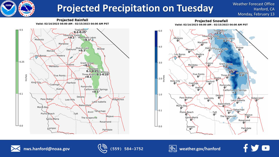
Mariposa Projected Precipitation: None
Oakhurst Projected Precipitation: Less than 0.01” Updated on Monday morning: None
Yosemite Valley Projected Precipitation: Less than 0.01”
February 12, 2023 - National Weather Service Hanford Office: Here are projected precipitation amounts for Monday night into Tuesday.
Precipitation amounts will be light, although snow amounts range from a dusting at the Grapevine and Tehachapi to around 6 inches in the higher elevations of the Sierra Nevada.
Snow levels will be mainly around 3,500 feet on Tuesday morning and lower to around 1,500 feet by Tuesday afternoon.
Area Forecast Discussion
National Weather Service Hanford CA
125 AM PST Mon Feb 13 2023
.SYNOPSIS...Expect relatively calm conditions with seasonal
temperatures today. A cold storm system will impact Central
California Tuesday and Tuesday night and result in mainly light
precipitation in the Sierra Nevada and strong wind gusts across
the Kern County mountains and desert areas. Skies will clear out
by Tuesday night and sub-freezing temperatures will be possible
in the San Joaquin Valley on Wednesday and Thursday mornings.
Another low pressure system will bring a return of unsettled
conditions Friday into next weekend.
&&
.DISCUSSION...Satellite loops show the upper-level low over the
Colorado River Valley in SE California that brought gusty
northeast winds yesterday. Some high clouds continue to rotate
around this low over the southern Sierra and into the Kern County
mountains. Expect mainly a calm day today with typical February
daytime temperatures today.
A much colder trough of low pressure will arrive on Tuesday and
bring increased northerly flow into the region. This will allow
very cold temperatures by Tuesday evening, with more widespread
freezing nighttime lows by Wednesday AM. With the arrival of the
colder air, the main threat will be gusty north/northwest winds
over the south end of the Sierra Nevada, as well as the Kern
County mountain and desert zones. Thus, we have launched a Wind
Advisory for these areas, except for a High Wind Warning over the
typical windy zone also known as the Mojave Desert Slopes. In
addition, mainly light precipitation is expected over the
mountains, although several inches of snow are expected to
accumulate in the higher elevations of the Sierra Nevada. A
dusting of snow is not out of the question for Tehachapi and the
Grapevine; at this time, the probability is about 40 percent at
Ft. Tejon for 0.1 inch of snow and about 20 percent for Tehachapi.
The resulting pattern for Wednesday morning and again Thursday
morning will likely be quite dry with plenty of opportunity for
overnight radiational cooling. So, we are not anticipating issues
with dense fog coupled with freezing overnight low temperatures
in the Central Valley at this time. More locations could reach
the upper 20's than in prior events during this winter so far.
There is even a chance that Bakersfield and Fresno could touch the
upper 20's (about 27 percent for both locations on Wednesday
morning, though a lesser chance for Fresno on Thursday). Also,
temperatures could drop much colder than average in the higher
terrain and desert areas on these days.
For Friday through at least next weekend, unsettled conditions
return to Central California as another upper-level trough arrives.
For now, we mainly have chances of around 20 to 30 percent for
showers on these days. Temperatures will remain cooler than
average, though with moderated nighttime lows due to increased
cloud cover. Ensemble guidance shows a lingering trough pattern
with a closed upper low that could cut off along the coast of
Central and Southern CA. Cluster analyses show notable uncertainty
regarding placement of the central low and associated trough,
including on the weekend into early next week.
&&
.AVIATION...VFR conditions will prevail across the central CA
interior for the next 24 hours.
&&
.AIR QUALITY ISSUES...On Monday February 13 2023, Fireplace/Wood
Stove Burning Status is: No Burning Unless Registered in Fresno
and Kern Counties. Burning Discouraged in Kings, Madera, Merced,
and Tulare Counties, and Kern (Greater Frazier Park Area) and
Sequoia National Park and Forest.
&&
.CERTAINTY...
The level of certainty for days 1 and 2 is medium.
The level of certainty for days 3 through 7 is medium.
Certainty levels include low...medium...and high. Please visit
www.weather.gov/hnx/certainty.html for additional information
and/or to provide feedback.
&&
.HNX WATCHES/WARNINGS/ADVISORIES...
High Wind Warning from 7 AM to 7 PM PST Tuesday for CAZ338.
Wind Advisory from 7 AM to 7 PM PST Tuesday for CAZ331-333-334-
337-339.
Freeze Watch from late Tuesday night through Thursday morning
for CAZ301>307-309>312-314>316.
Source: NWS

