


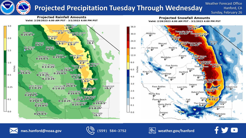
Projected Rainfall for Mariposa and Oakhurst 1.50" to 2.00"
Projected Snowfall for Mariposa: 8-12 inches
Projected Snowfall for Oakhurst: 8-12 inches
Projected Rainfall for Yosemite Valley: 2.00" to 3.00"
Projected Snowfall for Yosemite Valley: 30-36 inches
February 26, 2023 - The National Weather Service Hanford Office reports a storm system will be responsible for low elevation snow in the Sierra Nevada foothills and Kern County mountains, as well as rain in the San Joaquin Valley Tuesday through Wednesday.
Snow levels will be as low as 2,000 feet.
The majority of this precipitation will fall Tuesday night and Wednesday morning.
Area Forecast Discussion
National Weather Service Hanford CA
454 AM PST Sun Feb 26 2023
.SYNOPSIS...Storm system from the last couple days is exiting to
the east but the first in another series of systems will begin to
impact the region late this afternoon. Rain, mountain snow, and
gusty winds will continue at times through Wednesday. Dry weather
is forecast on Thursday and Friday but freezing temperatures are
likely across much of the San Joaquin Valley both mornings.
&&
.DISCUSSION...
Upper low responsible for heavy precipitation the last couple of
days is finally moving inland across southern California. There
were a couple more daily rainfall records set in the San Joaquin
Valley on February 25. Fresno-Yosemite International Airport had
0.69 inches of rain, tying the daily record rainfall set in 1940.
Bakersfield Meadows Field had 0.98 inches of rain, setting a new
daily record. Interstate 5 over the Grapevine Pass remains closed
due to snow and ice but is scheduled to reopen at 11 AM on Sunday.
Highway 58 over Tehachapi Pass just closed down again but with no
estimated time for reopening. The upper low will become an open
wave today and accelerate eastward across the Four Corners region.
But dry weather will be brief as another series of storm systems
will impact the region through midweek. A trough off the Pacific
Northwest coast this morning will begin to spread precipitation
into the northern portions of the district by late this afternoon
and reach Kern County overnight. This system will be followed by
a stronger system on Monday and then another from Tuesday through
Wednesday. Snow levels over the Sierra Nevada will begin around
3000 to 4000 feet today but lower to 2000 to 3000 feet on Monday.
Snow levels over the Kern County mountains will begin around 4000
feet Monday, lower to near 3000 feet Monday night and then hover
between 3000 and 4000 feet Tuesday and Wednesday. A Winter Storm
Warning has been issued for the Sierra Nevada beginning at 4 PM
this afternoon until 10 AM Monday. Winds will increase on Monday
and will create blowing snow and white-out conditions at times.
Therefore, a Blizzard Warning has been issued for the Sierra from
10 AM Monday through 4 PM Wednesday. NBM probabilities indicate
storm total snow accumulators over the high Sierra could range
from 3 to 7 feet. A Winter Storm Warning has been issued for the
Sierra Foothills above 2000 feet from 4 PM this afternoon through
4 PM Wednesday. The Kern County mountains will be under a Winter
Storm Warning from 4 AM Monday until 10 PM Wednesday. Snow levels
will be at or below the pass levels for the duration leading to
hazardous road conditions. Model ensemble means favor dry weather
on Thursday and Friday under short wave ridging. A cold air mass
in place will likely result in freezing temperatures across much
of the San Joaquin Valley on Thursday and Friday mornings.
&&
.AVIATION...Mountain obscuring IFR conditions with precipitation
spreading north to south after 00Z Monday. Local MVFR/IFR in rain
across the San Joaquin Valley after 00Z Monday. Elsewhere VFR
conditions will prevail across the central CA interior for the
next 24 hours.
&&
.AIR QUALITY ISSUES...
On Sunday February 26 2023, Fireplace/Wood Stove Burning Status
is: Burning Discouraged in Fresno, Kern, Kings, Madera, Merced,
and Tulare Counties, and Kern (Greater Frazier Park Area) and
Sequoia National Park and Forest.
&&
.CERTAINTY...
The level of certainty for days 1 and 2 is medium.
The level of certainty for days 3 through 7 is medium.
Certainty levels include low...medium...and high. Please visit
www.weather.gov/hnx/certainty.html for additional information
and/or to provide feedback.
&&
.HNX WATCHES/WARNINGS/ADVISORIES...
Winter Storm Warning from 4 PM this afternoon to 4 PM PST
Wednesday for CAZ318-320-322.
Winter Storm Warning from 4 PM this afternoon to 10 AM PST
Monday for CAZ323>331.
Blizzard Warning from 10 AM Monday to 4 PM PST Wednesday for
CAZ323>331.
Winter Storm Warning from 4 AM Monday to 10 PM PST Wednesday for
CAZ332>336.
Source: NWS

