


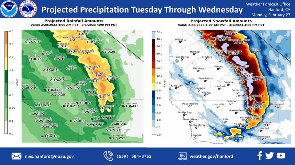
Projected Rainfall for Mariposa and Oakhurst 1.50" to 2.00"
Projected Snowfall for Mariposa: 8-12 inches Now 6-8 inches
Projected Snowfall for Oakhurst: 8-12 inches Now 6-8 inches
Projected Rainfall for Yosemite Valley: 2.00" to 3.00"
Projected Snowfall for Yosemite Valley: 30-36 inches Now 36-48 inches
February 27, 2023 - The National Weather Service Hanford Office reports a storm system will be responsible for low elevation snow in the Sierra Nevada foothills and Kern County mountains, as well as rain in the San Joaquin Valley Tuesday through Wednesday.
The majority of this precipitation will fall Tuesday afternoon and Tuesday night.
Area Forecast Discussion
National Weather Service Hanford CA
451 AM PST Mon Feb 27 2023
.SYNOPSIS...
Another series of storm systems will bring periods of rain, low
elevation snow, and gusty winds through Wednesday. Dry weather is
forecast on Thursday and Friday but freezing conditions are likely
across the San Joaquin Valley both mornings. More wet weather is
possible next weekend.
&&
.DISCUSSION...
Another upper trough is continuing to produce widespread light to
moderate precipitation since yesterday afternoon, mainly north of
Kern County thus far. Precipitation will enter Kern County later
this morning. Rain will taper off across the San Joaquin Valley
this morning though upslope flow will continue to produce showers
across the mountains. West southwest winds will increase across
the West Side Mountains and the western side of the San Joaquin
Valley this morning. A Wind Advisory has been issued for these
areas from 8 AM this morning until 10 PM tonight.
A couple more stronger systems will impact the region over the
next few days. A trough currently just off the Pacific Northwest
coast will slide southeast today spreading more precipitation
across the region. This is a stronger system and will bring
increased winds leading to enhanced upslope flow and orographic
lift. Heavy snow and strong winds in the Sierra Nevada will create
white-out conditions at times. A Blizzard Warning is in effect
for the Sierra beginning at 10 AM today until 4 PM Wednesday. A
Winter Storm Warning remains in effect for the Sierra Foothills
above 2000 feet until 4 PM Wednesday. A Winter Storm Warning is
also in effect the Kern County Mountains until 10 PM Wednesday.
A third trough will drop down on Tuesday bringing another round
of widespread precipitation into Wednesday. Rainfall from today
through Wednesday is expected to range from one quarter inch in
the southwest portion of the SJ Valley to around 1 inch in the
northern and eastern portions of the valley. Snow amounts in the
Sierra Foothills are forecast to range from 6 to 18 inches from
2000 to 3000 feet and 1 to 3 feet of snow from 3000 to 4000 feet.
The higher Sierra could see as much as 4 to 6 feet of snowfall.
Snow levels will be at or below the major highway passes in Kern
County for the duration of the event, resulting in accumulating
snowfall and hazardous travel conditions at times.
Model ensemble means agree the system exits the region Wednesday
night. Short wave ridging moves over Thursday and Friday for dry
conditions but a very cold air mass will be in place. There is a
high probability of freezing temperatures across most of the SJ
Valley both Thursday and Friday mornings. NBM probabilities for
low temperatures of 32 degrees or lower are 80 to 95 percent on
Thursday morning and 70 to 90 percent on Friday morning. Saturday
morning probabilities drop to 45 to 65 percent. An upper trough is
progged to move over the Pacific Northwest next weekend with the
potential for more wet weather in central California.
&&
.AVIATION...
Mountain obscuring IFR conditions in rain and snow. Local MVFR/IFR
in rain across the San Joaquin Valley. Elsewhere VFR conditions
will prevail across the central CA interior for the next 24 hours.
&&
.AIR QUALITY ISSUES...
On Monday February 27 2023, Fireplace/Wood Stove Burning Status
is: No Burning Unless Registered in Fresno and Madera Counties.
Burning Discouraged in Kern, Kings, Merced, and Tulare Counties,
and Kern (Greater Frazier Park Area) and Sequoia National Park and
Forest.
&&
.CERTAINTY...
The level of certainty for days 1 and 2 is medium.
The level of certainty for days 3 through 7 is medium.
Certainty levels include low...medium...and high. Please visit
www.weather.gov/hnx/certainty.html for additional information
and/or to provide feedback.
&&
.HNX WATCHES/WARNINGS/ADVISORIES...
Wind Advisory from 8 AM this morning to 10 PM PST this evening
for CAZ300-301-304-305-308-309-313.
Winter Storm Warning until 4 PM PST Wednesday for CAZ318-320-322.
Winter Storm Warning until 10 AM PST this morning for CAZ323>331.
Blizzard Warning from 10 AM this morning to 4 PM PST Wednesday
for CAZ323>331.
Winter Storm Warning from 4 AM early this morning to 10 PM PST
Wednesday for CAZ332>336.
Source: NWS

