


California and National Drought Summary for September 1, 2015
Summary
During the past 7-days, heavy rain (in excess of 2 inches) fell across portions of the Southern Atlantic Coast region (especially the Florida peninsula, and the coasts of both Georgia and the Carolinas), the coastal ranges and Cascades of the Pacific Northwest, the Midwest, Maine, and the southern Alaska Panhandle. Heavy rain also fell in portions of east-central Puerto Rico, in association with what was Tropical Storm Erika. Larger-scale areas of moderate precipitation (0.5-2 inches) were reported in the Southwest, remaining portions of the coastal ranges and Cascades of the Pacific Northwest, portions of both the Rockies and Great Plains, the north-central Mississippi Valley, the interior Southeast, parts of Ohio and Pennsylvania, and New England. Moderate precipitation was also reported across interior Alaska and the Seward Peninsula, the northern Alaska Panhandle, and much of the remainder of Puerto Rico.Alaska, Hawaii and Puerto Rico
One-category improvements were rendered to the depiction in both east-central Alaska and the southern Panhandle, based on recent precipitation amounts. The first area received anywhere from 0.5-3.0 inches, whereas the Panhandle received 3-5 inches or more. Rainfall data uncertainty in Hawaii this week resulted in no changes to the depiction, pending reassessment next week. Puerto Rico received some rain recently from what were tropical storms Danny and Erika, but not as much as was hoped for. Lake levels (Carraizo and La Plata) did rise over the weekend, but the Puerto Rico Water Authority notes that water rationing continues. Generally, 1-3 inches (locally greater) of rain fell with Erika, which at least did not result in any significant flash flooding. It will take time to assess Erika’s impacts across the island, hence no modifications were made to this week’s depiction.Lower Mississippi Valley
The continuing lack of precipitation and declining stream flows across much of Louisiana and southern Arkansas prompted one-category deteriorations in the drought depiction this week. Monroe, LA received only 1.62 inches of rain since July 1st, about 25 percent of normal, making this the driest corresponding period since 1980. The coastal parishes of southeastern Louisiana are experiencing deteriorating conditions and are presently consistent with borderline moderate to severe drought (D1 to D2) values (CPC’s 3-month SPI ranges between -1.3 and -1.5). This region seems ripe for additional degradation next week, assuming dry conditions persist. In west-central Mississippi, conditions continue to deteriorate, resulting in increased coverage of both moderate and severe drought (D1 and D2, respectively). Within the core of the Mississippi drought area, since July 1st, Jackson, MS has received only 1.89 inches of rain, making this the driest July-August period since 1924.Northeast and mid-Atlantic
Increasing dryness across much of this region prompted either the introduction or expansion of abnormal dryness (D0) across southwestern Vermont, east-central Massachusetts, Rhode Island, the borough of Queens in New York City and a small portion of northeastern New York State, New Jersey, and Virginia. During the past 30-days, AHPS Departure from Normal Precipitation (DNP) ranges between 1-4 inches in these areas, with the larger departures noted across southeastern Virginia. The hit-or-miss nature of summertime showers and thunderstorms is apparent from the 30-day precipitation deficits in the Maryland-Virginia area. Though the counties just south of the Nation’s Capital have been drying out, the Baltimore area has fared well this summer with near to above-average rainfall. An area of moderate drought (D1) was introduced to northeastern New Jersey, based on 60-day deficits and USGS stream flows mostly within the lowest quartile of the historical distribution for this day of the year. Moderate drought (D1) was also introduced to southeastern New Hampshire, where local authorities have instituted voluntary water restrictions on the Lamprey River.Northern and Central Plains
Slight adjustments were made to the D0 depiction in eastern and central Montana this week, based on recent rainfall. In Nebraska, three relatively small areas of abnormal dryness (D0) were introduced this week, based on increasing dryness. In the Panhandle, September is typically the time to plant hard red winter wheat. Warm, dry conditions are a concern in getting crop sown with good seed bed moisture and established with ample time for optimal root development prior to hardening off before the arrival of winter. In south-central Nebraska (Hall and Adams Counties), there were reports of dryland corn and beans rapidly deteriorating. Abnormal dryness (D0) was also added to extreme southeastern Nebraska (Pawnee and Richardson Counties). In northwestern, north-central, and central Kansas, D0 coverage was expanded based on 30-day and 60-day PNPs and the CPC 3-month SPI.Northern and Central Rockies
A continuing lack of precipitation across western Montana prompted a slight eastward shift of all drought categories. In north-central Colorado (southeastern and central Grand County) less than a quarter-inch of rain fell this week. This was a hot, dry period with high evaporative demand, prompting the introduction of a small area of abnormal dryness (D0) to the drought depiction.Ohio/Tennessee Valley
This is an important time of the year for soybeans in Kentucky, and rainfall is needed statewide. Though corn and tobacco are pretty much done for this growing season, and stream flows are close to normal, concern remains for the soybean crop and adequate soil moisture. A strip of abnormal dryness (D0) was added to the depiction extending from central to southwestern Kentucky this week to highlight the dryness.Pacific Northwest
Western Washington received anywhere from 1-5 inches of precipitation during the past 7-days, and streams have responded accordingly. Extreme drought (D3) was removed from the Olympic Peninsula, and was reduced on the windward slopes of the northern and central Cascades. With this recent upgrade somewhat at odds with the dominant short-term impacts designation (S), it was decided to remove the (S) designation, and keep SL (both short- and long-term impacts) across the Northwest.Southeast
An expansion of moderate drought (D1) conditions was rendered to the drought depiction in extreme western North Carolina, based on rainfall deficits and low stream flows, and in central North Carolina due to Corps reservoir reports. The spatial coverage of abnormal dryness (D0) was increased across northwestern portions of the state to match up with adjacent D0 in Virginia. In Georgia and Alabama, lots of small alterations (both improvements and deteriorations) were made to the depiction. Lots of small modifications were also made across the Sunshine State, with deterioration mainly across the Panhandle region where rainfall deficits are mounting, and improvements made in east-central and far southern Florida. Northern parts of the southern Florida drought area generally received 3-4 inches of rain this past week, with the remnants of what was Tropical Storm Erika. A one-category upgrade (from D2 to D1) was instituted across the heavily populated coastal areas of Miami-Dade and Broward Counties. Despite receiving some precipitation this week in Collier County, no changes were made to the depiction pending the future response of low water levels in Big Cypress National Preserve.Southern Plains
Lots of relatively small-scale adjustments were made to the drought depiction in Texas and Oklahoma this week, primarily deterioration. An area of extreme drought (D3) was added to east-central Texas. Along the border with southeastern Oklahoma, severe drought (D2) was expanded across southern McCurtain, Choctaw, eastern Bryan and southern Pushmataha Counties. Abnormal dryness was expanded northward into southern Le Flore and southern Latimer Counties. An area of D0 was added to part of far southwestern Oklahoma, based largely on soil moisture data. Plant Available Water (PAW) in this area at 4-, 16-, and 32-inch soil depths is approximately 0.10-inch, 0.50-inch, and 0.95-inch, respectively.Southwest and California
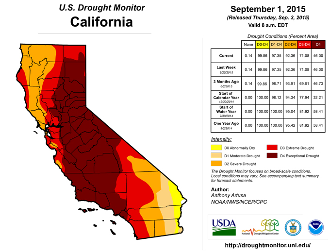
No alterations were made to the drought depiction this week in these areas. Conditions will be reassessed next week.Upper Great Lakes region and Midwest
: In northeastern Minnesota, southwestern Wisconsin, and northeastern Iowa, recent 1-3 inch rains resulted in either a one-category upgrade, or a reduction in size of a particular drought category. The moderate drought (D1) area in southwestern Wisconsin was retained north of the Wisconsin River, due to persistent deficits of 3-6 inches since June 1st.Looking Ahead
For the upcoming 5-day period, September 3-7, 2015, a swath of rain (1.5-2.0 inches) is forecast across eastern Arizona, much of western and central New Mexico, and western Colorado. For the southern Atlantic Coast, 1.5-3.5 inches of rain is predicted. Beneficial precipitation is also expected for western Washington (1.5 inches), northern Montana (2-4 inches), and western sections of both Virginia and North Carolina (1.5 inches). For the ensuing 5-day period, September 8-12, there are elevated odds for above-median precipitation for most of the central and eastern CONUS, and for the southern coast of Alaska. There are elevated odds for below-median precipitation for the northwestern CONUS and northwestern Alaska.Author(s):
Anthony Artusa, NOAA/NWS/NCEP/CPC
Dryness Categories
D0 ... Abnormally Dry ... used for areas showing dryness but not yet in drought, or for areas recovering from drought.Drought Intensity Categories
D1 ... Moderate DroughtD2 ... Severe Drought
D3 ... Extreme Drought
D4 ... Exceptional Drought
Drought or Dryness Types
S ... Short-Term, typically <6 months (e.g. agricultural, grasslands)L ... Long-Term, typically >6 months (e.g. hydrology, ecology)
Source: The National Drought Mitigation Center
