


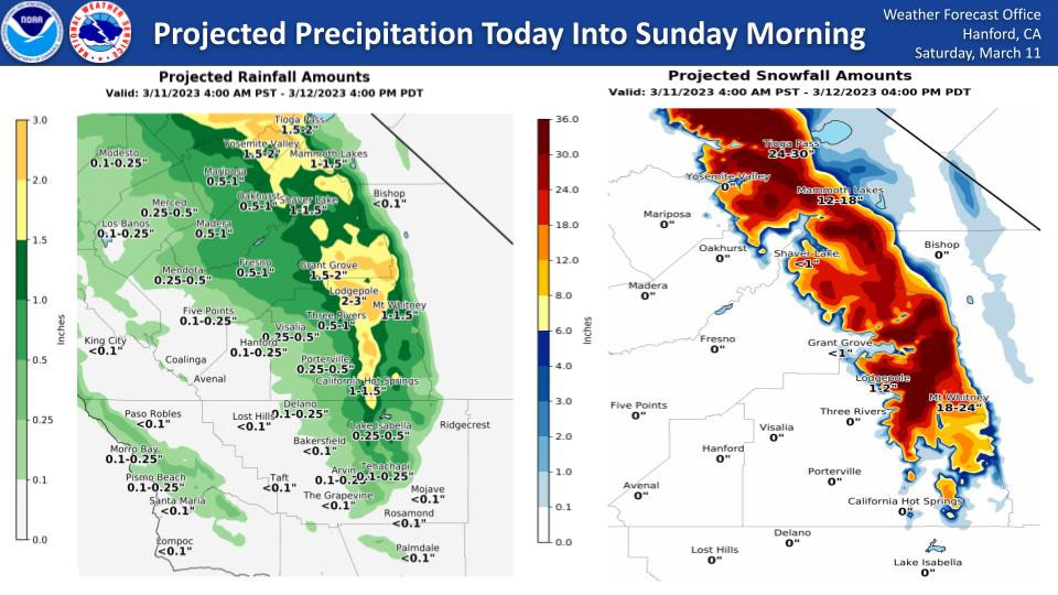
Projected Rainfall for Mariposa and Oakhurst 0.50" to 1.00"
Projected Rainfall for Yosemite Valley: 1.50" to 2.00"
March 11, 2023 - The National Weather Service Hanford Office reports periods of precipitation will linger in Central California today into Sunday morning.
Snow levels will generally be around 7,000 feet.
The majority of this precipitation will fall this afternoon and this evening.
Area Forecast Discussion
National Weather Service Hanford CA
1253 AM PST Sat Mar 11 2023
.SYNOPSIS...
The rain that began Friday will continue to last until Sunday.
Snow levels look to stay high at 8000 feet through today but will
drop to around 6500 feet on Sunday before rising back up at the
beginning of next week. Continued rainfall will aid in snow melt
from 2000 to 5000 feet. Rivers and streams all throughout our
county warning area are seeing rising waters and increased flows,
with flooding impacts in many areas. After this system passes
through completely on Sunday, there will be a brief reprieve
before another moderate weekend system impacts the area over the
early parts of the week.
&&
.DISCUSSION...
The atmospheric river combined with warm, moist air guided into
the area by an upper level low has been steadily making impacts to
our county warning area over the day in the form of high rain
totals in high elevations and very low snow levels. Mountain
slopes saw the brunt of this rainfall with high isolated totals,
and the warm air has begun melting snow below 5000 feet. Many
creeks and rivers across the CWA have been seeing impacts and
flooding and will continue to see flooding throughout the weekend.
Today and tonight, thunderstorm activity could result in more
localized flooding, isolated hail, high winds, and lightning. It
could also result in high localized mountain rain rates. The
eastern side of the Central Valley should see minimal
precipitation, if any. The western and southern portions of the
San Joaquin Valley could see up to a tenth of an inch of rain.
There will be a brief break in systems on Sunday before another system
begins to impact the area Monday night into Wednesday. The
eastern and central San Joaquin Valley will see totals from 1.5 to
2 inches of rain, while the western part of the valley will see 1
to 1.5 inches of rain. While rain totals in the Sierra and Sierra
foothills will be high in many places, they will not be as high
as the rain totals we saw this weekend. Some areas and rain totals
are:
Fresno, California Hot Springs, and Three Rivers: 2-3 inches Mt
Whitney and Mammoth Lakes: 3-4 inches Lodgepole, Grant Grove,
Shaver Lake, Oakhurst, Mariposa, Yosemite Valley, and Tioga Pass:
4-6 inches Grant Grove: 6-8 inches
There will be a brief break in systems on Sunday before another
system begins to impact the area Monday night into Wednesday. The
eastern and central San Joaquin Valley will see totals from 1.5 to
2 inches of rain, while the western part of the valley will see 1
to 1.5 inches of rain. While rain totals in the Sierra and Sierra
foothills will be high in many places, they will not be as high as
the rain totals we saw this weekend. Some areas and rain totals
are:
Fresno, California Hot Springs, and Three Rivers: 2-3 inches
Mt Whitney and Mammoth Lakes: 3-4 inches
Lodgepole, Grant Grove, Shaver Lake, Oakhurst, Mariposa, Yosemite Valley, and
Tioga Pass: 4-6 inches
Grant Grove: 6-8 inches
Snow levels for this storm will be slightly lower and places that saw no
snow with this weekend storm will see snow with the Monday-
Wednesday storm. Snow levels will start at roughly 7000 feet, rise
to 8000 feet, and then lower to about 6000 feet by Wednesday when
the system begins to move out of the area. Snow total forecasts
are:
Shaver Lake: 3-4 inches
Grant Grove: 4-6 inches
Lodgepole: 8-12 inches
Mammoth Lakes: 24-30 inches
Mt. Whitney: 36-48 inches
Tioga Pass: 48-72 inches
&&
.AVIATION...
The San Joaquin Valley can see continued MFVR conditions with rain
showers and possibly IFR conditions in mountains due to heavier
possible precipitation. Some turbulence is expected due to low
level winds and mountain precipitation.
&&
.AIR QUALITY ISSUES...
ISSUED: 03/11/2023 13:41
EXPIRES: 03/12/2023 23:59
None.
&&
.CERTAINTY...
The level of certainty for days 1 and 2 is medium.
The level of certainty for days 3 through 7 is medium.
Certainty levels include low...medium...and high. Please visit
www.weather.gov/hnx/certainty.html for additional information
and/or to provide feedback.
&&
.HNX WATCHES/WARNINGS/ADVISORIES...
Flood Watch through Wednesday morning for CAZ300>336.
Winter Storm Warning until 10 AM PDT Sunday for CAZ323-326>331.
Source: NWS

