


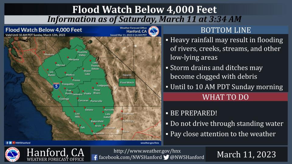
Includes Merced, Fresno, Madera and Mariposa Counties and Yosemite Valley
March 11, 2023 - The National Weather Service Hanford Office reports water levels are extremely high on area rivers, creeks, and streams.
Heavy rainfall below 7,000 feet and melting snow from 2,000 feet to 4,000 could cause flooding or worsen ongoing flooding today into Sunday morning.
The heaviest rainfall is expected this afternoon and this evening.
Flood Watch
National Weather Service Hanford CA
716 AM PST Sat Mar 11 2023

West Side Mountains north of 198-Los Banos - Dos Palos-Merced -
Madera - Mendota-Planada - Le Grand - Snelling-Coalinga - Avenal-
West Side of Fresno and Kings Counties-Caruthers - San Joaquin -
Selma-Fresno-Clovis-West Side Mountains South of 198-Buttonwillow -
Lost Hills - I5-Delano-Wasco-Shafter-Hanford - Corcoran - Lemoore-
Visalia - Porterville - Reedley-Buena Vista-Bakersfield-Southeast
San Joaquin Valley-South End San Joaquin Valley-Mariposa Madera
Foothills-Mariposa-Madera Lower Sierra-Fresno-Tulare Foothills-
Fresno-Tulare Lower Sierra-South End Sierra Foothills-South End of
the Lower Sierra-Yosemite NP outside of the valley-Yosemite Valley-
San Joaquin River Canyon-Upper San Joaquin River-Kaiser to Rodgers
Ridge-Kings Canyon NP-Grant Grove Area-Sequoia NP-South End of the
Upper Sierra-Kern River Valley-Piute Walker Basin-Tehachapi-
Grapevine-Frazier Mountain Communities-
Including the cities of Kingsburg, Millerton Lake, Tehachapi, Hume
Lake, Atwater, Goshen, Oakhurst, Bakersfield, El Portal, Florence
Lake, Mariposa, Kettleman City, Richgrove, Avenal, Tuolumne Meadows,
Parlier, Coalinga, Hanford, Lemoore, Wasco, North Fork, Taft, Shaver
Lake, Cedar Grove, Lebec, Kerman, Lost Hills, Johnsondale, Lemoore
Station, Arvin, Lake Isabella, Five Points, Yosemite Valley, Selma,
Madera, Tulare, Los Banos, Lake Thomas Edison, Grant Grove, Shafter,
McKittrick, Devils Postpile, Corcoran, Bass Lake, Auberry,
Huntington Lake, Camp Nelson, Le Grand, Lodgepole, Coarsegold,
Alpaugh, Lake Mcclure, Porterville, Lamont, Giant Forest, Planada,
Blackwells Corner, Delano, Fish Camp, Visalia, Sanger, Lake Wishon,
Kernville, Wawona, Grapevine, Merced, Frazier Park, San Luis
Reservoir, Buttonwillow, and Fresno
716 AM PST Sat Mar 11 2023

...FLOOD WATCH REMAINS IN EFFECT THROUGH WEDNESDAY MORNING...

* WHAT...Flooding caused by excessive rainfall continues to be
  possible.

* WHERE...A portion of central California, including the following
  areas, Bakersfield, Buena Vista, Buttonwillow - Lost Hills - I5,
  Caruthers - San Joaquin - Selma, Coalinga - Avenal,
  Delano-Wasco-Shafter, Frazier Mountain Communities, Fresno-Clovis,
  Fresno-Tulare Foothills, Fresno-Tulare Lower Sierra, Grant Grove
  Area, Grapevine, Hanford - Corcoran - Lemoore, Kaiser to Rodgers
  Ridge, Kern River Valley, Kings Canyon NP, Los Banos - Dos Palos,
  Mariposa Madera Foothills, Mariposa-Madera Lower Sierra, Merced -
  Madera - Mendota, Piute Walker Basin, Planada - Le Grand -
  Snelling, San Joaquin River Canyon, Sequoia NP, South End San
  Joaquin Valley, South End Sierra Foothills, South End of the Lower
  Sierra, South End of the Upper Sierra, Southeast San Joaquin
  Valley, Tehachapi, Upper San Joaquin River, Visalia - Porterville
  - Reedley, West Side Mountains South of 198, West Side Mountains
  north of 198, West Side of Fresno and Kings Counties, Yosemite NP
  outside of the valley and Yosemite Valley.

* WHEN...Through Wednesday morning.

* IMPACTS...Excessive runoff may result in flooding of rivers,
  creeks, streams, and other low-lying and flood-prone locations.
  Creeks and streams may rise out of their banks. Flooding may occur
  in poor drainage and urban areas. Low-water crossings may be
  flooded. Extensive street flooding and flooding of creeks and
  rivers are possible.

* ADDITIONAL DETAILS...
  - Heavy rain and snow melt anticipated.
  - http://www.weather.gov/safety/flood

PRECAUTIONARY/PREPAREDNESS ACTIONS...

You should monitor later forecasts and be alert for possible Flood
Warnings. Those living in areas prone to flooding should be prepared
to take action should flooding develop.
Source: NWS

