


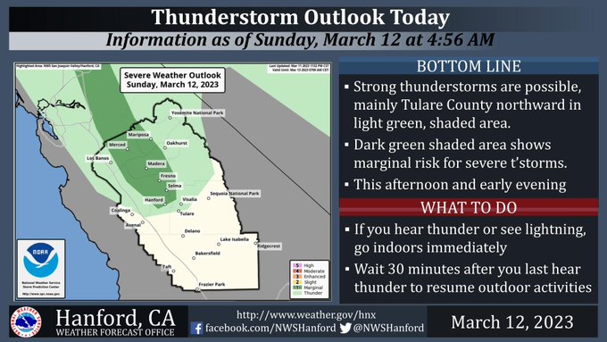
Includes Mariposa County, Madera County, and Yosemite National Park
March 12, 2023 - National Weather Service Hanford Office officials say strong thunderstorms are possible, mainly Tulare/Kings Counties northward (areas in shaded in light green) for this afternoon until early this evening.
Small hail and wind gusts near 45 miles per hour are a couple of hazards associated with strong thunderstorms.
There is also a marginal risk of severe thunderstorms (dark green shaded area), which could produce gusts of 58 mph or higher, as well as quarter size (1 inch diameter) hail or larger.
In addition to dangerous cloud to ground lightning strikes, any thunderstorm can produce intense rainfall rates, leading to localized flooding.
Area Forecast Discussion
National Weather Service Hanford CA
1231 AM PST Sun Mar 12 2023
.SYNOPSIS...
Scattered showers and thunderstorms are expected tonight into the
following evening. This rainfall will continue to aid in snow
melt for elevations below 5000 feet. Rivers and Streams, in our
CWA, continue to see increased river flows and flooding due to
recent storm activity. The next system will bring a chance of
moderate to heavy rain and high elevation snow Monday night into
Wednesday which will pose additional flooding concerns.
&&
.DISCUSSION...
Latest radar imagery shows moderate to heavy rain near Three
Rivers gradually weakening. Latest high resolution guidance shows
decreasing activity overnight, although a few showers or an
isolated thunderstorms cannot be ruled out. The next chance for
convection occurs by this afternoon, and scattered showers and
thunderstorms return once again. Guidance suggests weak upper-
level ridging while subtropical moisture pushes northward for this
afternoon, so it appears chances will be limited to mainly Fresno
County northward. Most of our region will get a brief break from
Sunday night until Monday morning, and the next system arrives by
Monday evening. However, the mountain areas will likely get
showers continuing on Sunday night into Monday as another
shortwave trough moves in ahead of the main system.
Precipitation will begin Monday night and will increase in
intensity overnight into Tuesday with this next system. Another
plume of deep subtropical moisture will arrive late Monday
night/early Tuesday morning and remain in our area into at least
Tuesday night when the bulk of the precipitation will occur.
Timing of the arrival of this deeper moisture has been delayed a
bit with the latest model runs, so it appears the arrival will
mainly be late Monday night rather than Monday afternoon. Chances
for rain and high elevation snow will last until Wednesday.
Additional remaining snow on the ground in the lower elevations
will continue to melt. The latest precipitation amounts are about
one to two inches in the San Joaquin Valley, except around 0.50 to
1.00 inch in Kern County. Sierra foothill amounts vary from 1.50
to 5.00 inches, with the highest amounts from Mariposa County to
around Three Rivers in Tulare County. Sierra Nevada rainfall will
range from around three to six inches at elevations up to around
7,000 feet. The probability for the corresponding amounts of rain
range from around 40 to 70 percent. Heavy snow will once again
fall above 7,000 feet, so the Winter Storm Warning will continue
until Wednesday. Expect a total of 2-4 feet of snow in the Sierra
Nevada for the 7000 to 8000 foot level, 4-6 feet at 8000 to 9000
feet, and 6-9 feet above 9000 feet from Monday evening until
Wednesday. The probabilities are around 50 to 70 percent for these
totals.
Relatively cool and unsettled conditions will continue into late
next week, though we could get a break for Thursday. Another
system arrives on Friday, and chances for precipitation will last
into the following weekend. It does not appear we will receive
nearly as much precipitation at this time.
&&
.AVIATION...
The San Joaquin Valley can see continued MFVR conditions with rain
showers and possibly IFR conditions in mountains due to heavier
possible precipitation in the form of thunderstorms until 03Z
Monday. Otherwise, VFR conditions are expected throughout the
central California interior for the next 24 hours.
&&
.AIR QUALITY ISSUES...
None.
&&
.CERTAINTY...
The level of certainty for days 1 and 2 is high.
The level of certainty for days 3 through 7 is medium.
Certainty levels include low...medium...and high. Please visit
www.weather.gov/hnx/certainty.html for additional information
and/or to provide feedback.
&&
.HNX WATCHES/WARNINGS/ADVISORIES...
Flood Watch through Wednesday morning for CAZ300>336.
Winter Storm Warning until 5 PM PDT Wednesday for CAZ323-326>331.
Source: NWS

